All Activity
- Past hour
-
Stormnet ringing bells for us Thursday. For those unaware, Stormnet is a new AI tool for SVWX forecasting that came out this year and has performed exceptionally well. Green is about equivalent to an SPC slight or enhanced, so this is quite a strong signal for d5. I know some may hesitate due to relatively modest forecast EMLs, but globals tend to underestimate thermos, and with the forecast shear (60-70+ EBWD and 300+ 3k SRH), I wouldn't want to count anything out. We await the king NAM.

-
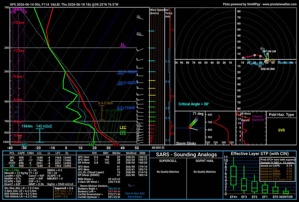
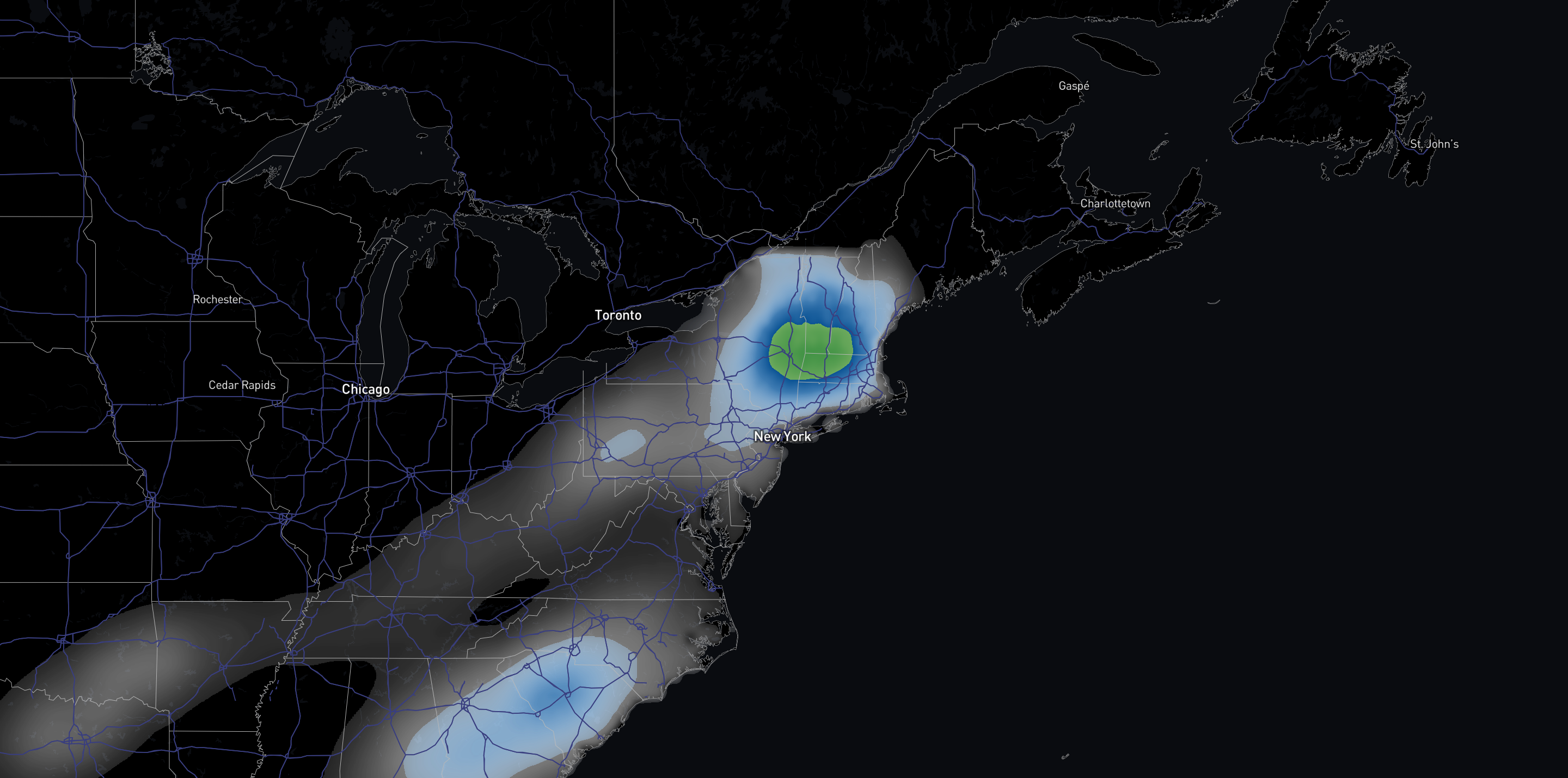
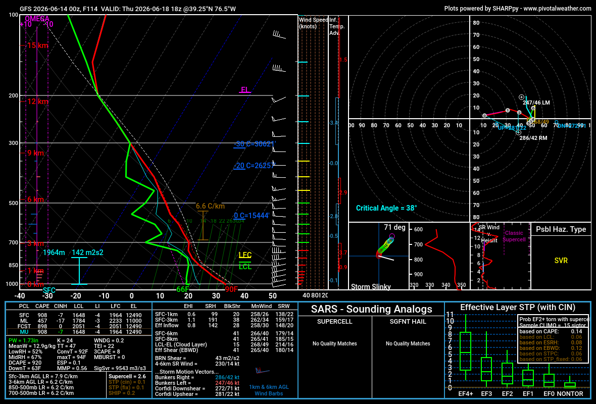
Since I'm back home in Boston, I've mostly been following our weather, but I wanted to stop by here. Obviously, insanely potent jet for this time of year, with 100+ kt on Wednesday over the Midwest and nearly 100kt as it takes on a negative tilt on Thursday over NE, both per 00z euro. The GooFuS solution favors you all with the trough swinging down a little bit more and overspreading the region with 40-50kt flow, which is good for this time of year. It should be noted that with these super-fast (speed and translation) punching jets, you don't need to be right in the centroid to see good storms. Deep-layer shear should be pretty good due to the strength of the jet, although it remains to be seen whether the LLJ and associated SRH will reach down to MA. Attached is a model sounding at BWI at 18z from the 00z GFS. 41 EBWD supportive of supercells, but, as you can see, it's mostly speed shear with no real turning with height due to a very modest 850mb jet. CAPE is skinny on this sounding in particular, but I wouldn't worry, as many others were 1000-1500+, and globals tend to underestimate thermos anyways. We will have to wait for the SVWX king, the NAM, to bring us the goods.
- 664 replies
-
- 1
-

-
- severe
- thunderstorms
- (and 7 more)
- Today
-
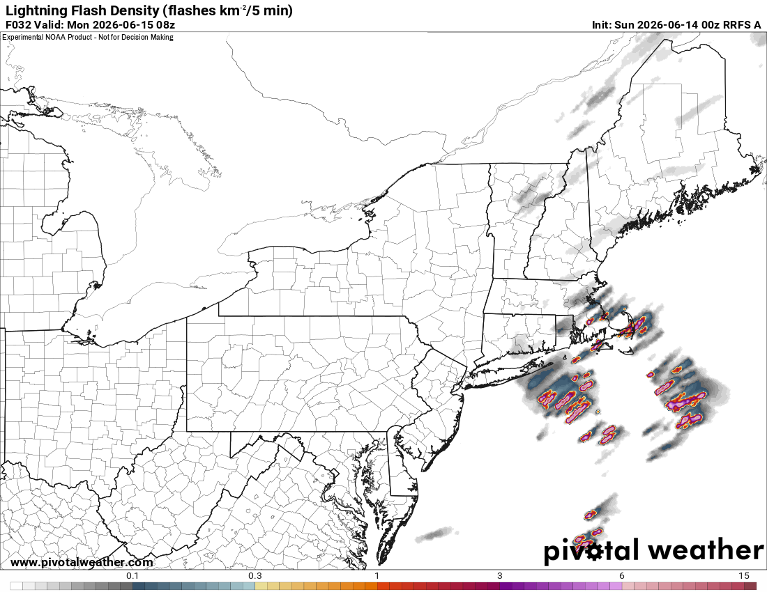
NNE looks good for short bow segments and supercells today. What is interesting is 2-5am Mon in eastern SNE. Nice theta-e noses at 925 and 850 and wind fields 700 and below ramp up nicely just ahead of the well-defined trough axis. 00z RRFS and to a lesser extent HRRR show decent tstms firing ern MA and RI. LTG density is solid. So maybe CoastalWx can get shaken out of bed w/ a +CG super crash! LOL.
-
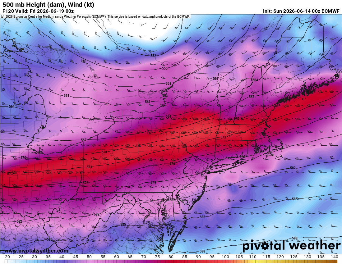
Yes. I see that. Noted on the 00z ECMWF, very strong WAA occurs on Thu during the day with the passage of the WF (that's classic for a big tor day). Nice nose of above avg 850 temp 00z 6/19 (attached). Winds at 500 as high at 95 kt (attached) and 300 winds as high as 115 kt? Tell me something big can *not* happen w/ these kind of wind anomalies and such a strong sfc low in srn Quebec in June! Derecho instead of Scott spinners here perhaps. Looks better to SW of the region. Since set ups like this are rare here, we don't know the full range of possibilities. We may be surprised.


-
Monday and Tuesday look to be a sharp contrast from this week's heat and humidity with low dews and 50's at night. Then Wed-Friday maybe some rain chances as the humidity picks back up?
-
Dry begets dry.
-
Busy Weather Day Sunday
-
what an awesome NBA finals. Man The Knicks were on fire 15-1 in the last 16 games. As much I don't like Dolan, the owner, but that team was sick. Great comebacks through out the finals. OG and Brunson are a scary duo
-
Was in Brier Creek this afternoon and it rained enough at the intersection of BC Pkwy and Glenwood to wet the road and had to use my wipers twice, but a mile away bone dry. Thought something may pop this evening but no dice. onto another hot one sunday.
-
As for SA, they are young and talented, and will probably win a few championships. Wemby is very good, but needs to bulk up a bit, and MUST develop a game in the low post with his size. Hate seeing him shooting threes all the time.
-
having the top guys from the 2016/2018 national champion 'Nova teams was a brilliant GM move. Brunson is definitely one of my favorite players.
-
He doesnt look like the quintessential NBA superstar- not flashy, but the dude just gets it done. Humble and a class act too. I hate seeing any NY team win, but just can't root against that guy.
-
Brunson is a killer man. Dude is on Kobe or Jordan's level in terms of that.
-
https://www.kissin925.com/eye-in-the-sky/ time-sens, nice storms near Joplin MO
-
that 3k NAM looked pretty good for tomorrow night.
-
Nice baroclinic support so far into June with the GEFS, EPS, and AIFS ensemble means all showing a 992-995mb low traversing southern Lake Michigan late Wednesday. Looks like most likely a cool rain for MBY.
-
Checking in from Alaska. We ended the winter with 77 inches of snow which was only 1 inch below average. Coldest winter in nearly 20 years. Coldest March on record. 4th coldest Spring on record. Snowiest January on record which made up for the snowless December. Highest wind gust ever recorded at Anchorage airport when we hit 75MPH back in December. December was a beast when it came to these back to back destructive Matansuka Valley wind events. I'm seeing a lot of photos and videos from Waycross, GA today on Facebook of significant damage from that thunderstorm earlier today. No warning was on it and multiple people are saying it was absolutely a tornado. That or a microburst. Interesting video from the storm below. https://www.facebook.com/share/r/1LW4kAXRzY/
-
RDU high a “much cooler” 96 today vs 103 yesterday.
-
0.00” here for the day, 0.00” for the month
-
I'm originally from just NW of BOS, and the biggest thing I recall locally from that 6/1/11 was the nasty +CGs coming out of the supercell anvils overhead. The storm cores were 30 mi to my W. Don't see that too often in New England! Then another supercell just missed me in the evening that crushed BOS. Here is video (not mine) taken about 10 mi to my N in Lowell MA. This is telltale supercell lightning. Very frequent, quick flickering pulses in the upper part of the CB. You can actually see short cloud-to-cloud bolts at times, known in chaser slang as, "anvil zits!"
-
It's gonna rain.
-
It's frustrating that I had three tornadoes within a few miles of my house and I couldn't see any of them. All three were embedded in the line that was producing widespread 65-70 MPH straight-line gusts. June 13, 2026 National Weather Service Confirms Three EF1 Tornadoes in Huntington County HUNTINGTON COUNTY, IN — The National Weather Service Northern Indiana has completed official storm damage surveys following the severe weather event that impacted Huntington County on June 11, 2026. Survey teams confirmed three EF1 tornadoes occurred across portions of Huntington County with estimated peak winds of 95 mph. No fatalities or injuries were reported. Andrews, IN Tornado Rating: EF1 Estimated Peak Wind: 95 mph Path Length: 5.83 miles Maximum Width: 75 yards Fatalities: 0 Injuries: 0 Start Date: June 11, 2026 Start Time: 10:33 PM EDT Start Location: 3 SSW Andrews / Huntington County / IN Start Lat/Lon: 40.8146 / -85.6399 End Date: June 11, 2026 End Time: 10:41 PM EDT End Location: 2 ENE Andrews / Huntington County / IN End Lat/Lon: 40.8708 / -85.5574 Survey Summary: A tornado developed southwest of Andrews, racing northeast toward Huntington. At least two properties on W Division Rd were impacted, as indicated by a loss of shingles, siding, and roof panels. Numerous trees were damaged as well, including trees snapped. Near the intersection of W 100 N and N 800 W, additional tree damage was observed and an outbuilding lost several roof panels. Along W 200 N, a number of trees were damaged at one property. Across the street, a mobile home lost its roof. The tornado appears to have lifted prior to reaching the Yake Subdivision, just south of the Wabash River. In the subdivision, isolated tree branches were down. Warren, IN – 4 Miles Northwest Tornado Rating: EF1 Estimated Peak Wind: 95 mph Path Length: 7.90 miles Maximum Width: 50 yards Fatalities: 0 Injuries: 0 Start Date: June 11, 2026 Start Time: 10:39 PM EDT Start Location: Pleasant Plain / Huntington County / IN Start Lat/Lon: 40.6993 / -85.5487 End Date: June 11, 2026 End Time: 10:48 PM EDT End Location: 1 WSW Plum Tree / Huntington County / IN End Lat/Lon: 40.7377 / -85.4080 Survey Summary: A tornado touched down north of Pleasant Plain, at a residence on S 500 W. Here, nearly two dozen trees were damaged, including multiple trees snapped at least halfway up their trunks. Tree damage appeared to continue into a tree line off to the northeast. Throughout its nearly 8-mile-long path to the northeast, sporadic instances of tree damage occurred until it approached State Route 5, just northwest of I-69. Here, the tornado caused almost total destruction to a newly built barndominium. Only the eastern wall was left standing with debris lofted at least 100 yards into adjacent fields. Tree damage continued east-northeast of here where at least two tree trunks were snapped. The tornado lifted just east of I-69, along S 200 E. Huntington, IN – 2.5 Miles Northeast Tornado Rating: EF1 Estimated Peak Wind: 95 mph Path Length: 0.65 miles Maximum Width: 25 yards Fatalities: 0 Injuries: 0 Start Date: June 11, 2026 Start Time: 10:44 PM EDT Start Location: 2 NW Bowerstown / Huntington County / IN Start Lat/Lon: 40.9122 / -85.4743 End Date: June 11, 2026 End Time: 10:45 PM EDT End Location: 2 NW Bowerstown / Huntington County / IN End Lat/Lon: 40.9178 / -85.4644 Survey Summary: In an open area north of US 24 and east of State Route 9, an incredibly brief tornado appears to have touched down and impacted a single residence. Here, a two-story home completely lost its roof and debris was deposited into adjacent fields. Hardly any rafters remain and no roof decking is present. Intense dirt and insulation splatter was noted on the east and north side of the home. Additionally, a detached garage to the south-southeast of the home was demolished by the tornado. A property less than 500 yards to the northeast was not impacted, suggesting the tornado quickly lifted beyond 600 N.
-
Shoulda known better
-
Retired model
-
June 1, 2011 was the New England tor event w/ the EF3 Springfield-Monson MA. This is the last high-end tor event for New England, About every 10-15 years New England gets a high-end tor event, so one could say, "they're due!"


.thumb.gif.f92b16c631a1d15d405ed77b33f0710d.gif)


