All Activity
- Past hour
-
91mph wind gust reported by spotter 2 E Mokena IL
-
Line is moving. Going to eat up the stuff ongoing in central in
-
Really lucked out. It was a non-event IMBY.
-
 http://mapletrustrx.com/# Maple Trust Rx
 -
It sucks we have NAZI's like @A-L-E-K and @warywarren, whose account is still active, posting here. It would be awesome to discuss weather without two Jew haters lingering around.
-

2026-2027 Record-breaking El Nino
TriPol replied to Stormchaserchuck1's topic in Weather Forecasting and Discussion
Where are the fooking mods? You guys got a beef with each other? Take it somewhere else. Stop ruining our experience in reading about a once in a lifetime weather event. -
Well… then again…
-
Severe Weather Statement National Weather Service Chicago/Romeoville 1108 AM CDT Tue Aug 11 2026 INC089-127-111645- /O.CON.KLOT.TO.W.0075.000000T0000Z-260811T1645Z/ Porter IN-Lake IN- 1108 AM CDT Tue Aug 11 2026 ...A TORNADO WARNING REMAINS IN EFFECT UNTIL 1145 AM CDT FOR PORTER AND EAST CENTRAL LAKE COUNTIES... At 1107 AM CDT, a severe squall line capable of producing both tornadoes and extensive straight line wind damage was racing toward Porter County at over 75 mph. HAZARD...Tornadoes and wind gusts in excess of 100 mph. SOURCE...Radar indicated rotation. IMPACT...Flying debris will be dangerous to those caught without shelter. Mobile homes will be damaged or destroyed. Damage to roofs, windows, and vehicles will occur. Tree damage is likely. These dangerous storms will be near... Valparaiso around 1115 AM CDT. PRECAUTIONARY/PREPAREDNESS ACTIONS... TAKE COVER NOW! Move to a basement or an interior room on the lowest floor of a sturdy building. Avoid windows. If you are outdoors, in a mobile home, or in a vehicle, move to the closest substantial shelter and protect yourself from flying debris. This cluster of thunderstorms is capable of producing tornadoes and widespread significant wind damage. Do not wait to see or hear the tornado. For your protection move to an interior room on the lowest floor of a building. && LAT...LON 4122 8697 4127 8706 4129 8712 4127 8719 4124 8722 4162 8723 4163 8716 4165 8715 4165 8710 4171 8693 4124 8693 TIME...MOT...LOC 1607Z 275DEG 59KT 4145 8727 TORNADO...RADAR INDICATED MAX HAIL SIZE...0.00 IN
-
Severe Weather Statement National Weather Service Chicago/Romeoville 1108 AM CDT Tue Aug 11 2026 INC089-127-111645- /O.CON.KLOT.TO.W.0075.000000T0000Z-260811T1645Z/ Porter IN-Lake IN- 1108 AM CDT Tue Aug 11 2026 ...A TORNADO WARNING REMAINS IN EFFECT UNTIL 1145 AM CDT FOR PORTER AND EAST CENTRAL LAKE COUNTIES... At 1107 AM CDT, a severe squall line capable of producing both tornadoes and extensive straight line wind damage was racing toward Porter County at over 75 mph. HAZARD...Tornadoes and wind gusts in excess of 100 mph. SOURCE...Radar indicated rotation. IMPACT...Flying debris will be dangerous to those caught without shelter. Mobile homes will be damaged or destroyed. Damage to roofs, windows, and vehicles will occur. Tree damage is likely. These dangerous storms will be near... Valparaiso around 1115 AM CDT. PRECAUTIONARY/PREPAREDNESS ACTIONS... TAKE COVER NOW! Move to a basement or an interior room on the lowest floor of a sturdy building. Avoid windows. If you are outdoors, in a mobile home, or in a vehicle, move to the closest substantial shelter and protect yourself from flying debris. This cluster of thunderstorms is capable of producing tornadoes and widespread significant wind damage. Do not wait to see or hear the tornado. For your protection move to an interior room on the lowest floor of a building. && LAT...LON 4122 8697 4127 8706 4129 8712 4127 8719 4124 8722 4162 8723 4163 8716 4165 8715 4165 8710 4171 8693 4124 8693 TIME...MOT...LOC 1607Z 275DEG 59KT 4145 8727 TORNADO...RADAR INDICATED MAX HAIL SIZE...0.00 IN
-
Oh ok Severe Weather Statement National Weather Service Chicago/Romeoville 1108 AM CDT Tue Aug 11 2026 INC089-127-111645- /O.CON.KLOT.TO.W.0075.000000T0000Z-260811T1645Z/ Porter IN-Lake IN- 1108 AM CDT Tue Aug 11 2026 ...A TORNADO WARNING REMAINS IN EFFECT UNTIL 1145 AM CDT FOR PORTER AND EAST CENTRAL LAKE COUNTIES... At 1107 AM CDT, a severe squall line capable of producing both tornadoes and extensive straight line wind damage was racing toward Porter County at over 75 mph. HAZARD...Tornadoes and wind gusts in excess of 100 mph. SOURCE...Radar indicated rotation. IMPACT...Flying debris will be dangerous to those caught without shelter. Mobile homes will be damaged or destroyed. Damage to roofs, windows, and vehicles will occur. Tree damage is likely. These dangerous storms will be near... Valparaiso around 1115 AM CDT. PRECAUTIONARY/PREPAREDNESS ACTIONS... TAKE COVER NOW! Move to a basement or an interior room on the lowest floor of a sturdy building. Avoid windows. If you are outdoors, in a mobile home, or in a vehicle, move to the closest substantial shelter and protect yourself from flying debris. This cluster of thunderstorms is capable of producing tornadoes and widespread significant wind damage. Do not wait to see or hear the tornado. For your protection move to an interior room on the lowest floor of a building. && LAT...LON 4122 8697 4127 8706 4129 8712 4127 8719 4124 8722 4162 8723 4163 8716 4165 8715 4165 8710 4171 8693 4124 8693 TIME...MOT...LOC 1607Z 275DEG 59KT 4145 8727 TORNADO...RADAR INDICATED MAX HAIL SIZE...0.00 IN
-
.thumb.gif.f92b16c631a1d15d405ed77b33f0710d.gif)
Augdewst 2026: Summer's Last Stand
Torch Tiger replied to Prismshine Productions's topic in New England
going to be wild -
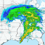
radar est rainfall #s already extreme for a large chunk of nw in with the motherload still incoming
-
Warned for gusts to 100 mph now
-
Yeah we originally thought to just get the chainsaw out and cut that off but as I am aging and winter is long and cold up there I appreciate having a handhold so I don't slip and break my back.
-
Some 108-110mph bins in that mix near crown point
-
-
This board both ignored and laundered antisemitism for years. The genesis and radicalization happened here. This board bears some responsibility for ALEK and WARREN's behavior, as WARREN chases me all over the internet. I have no idea who the guy is, other than nazi @A-L-E-Kfriend.
-
Augdewst 2026: Summer's Last Stand
Torch Tiger replied to Prismshine Productions's topic in New England
insane live feeds of this. -
Sheesh. No wonder they just tornado warned the whole line
-
Ahh, yeah that would make sense considering the scope of the state down there. IL doing it is absolutely nuts.
-
Don't look now folks but you have a couple more blobs coming in from the Midwest. It's going to be rain blob after rain blob, especially once that Nino really starts exerting on the 500 millibar pressure layer in the United States. Washington DC is right in the right front quadrant so to speak of the Nino's rain shield. You guys are going to get really tired of rainfall soon. Right now you are getting missed and people are eyeing the ledges because of rain hunger, but this is a 6C Nino and it means serious, serious bisnass. It will not spare and it will have absolutely no mercy at all. Flooding for some communities will become a way of life. Just ask Asheville, North Carolina. Damnit Indiana, Pennsylvania is catching up to Buda. We have actually been leading the Nation in so far this year rainfall tallies, with 35.7 inches, but Penn is catching up quick. At one point we were 9 inches ahead of them. Soon the Nino will have that place and the DMV in the 180s of inches while Buda will be STUCK in the middle 30s because we are way too far west in an incredibly record east-based Nino. This late summer, autumn, winter and Spring 2027, if you don't like rain, DON'T BE IN THE DMV, THE SOUTHEASTERN STATES OR THE MID-SOUTH GULF STATES (excluding Texas) Or in Missouri, Tennessee, Kentucky, places like that. East Texas will whiff cirrus on this nino. The DMV will soon be actively exploring all the different ways you can get drenched by excessive rain. Front will get hung up over DC. Torrential rain will soon follow. Blobs will invade you from the northwest, adding to the saturated ground. DO NOT BE NEAR ROCK CREEK. A storm will somehow manage to retrograde in from the ocean and you will have a chilly marine layer plus heavy soaking rain. Ordinary lows will move in over you from the southwest, loaded up with heavy rain from the roided up jet stream. It will also become quite chilly because Nino loves to bring cooler than normal temperatures. It's going to be a long autumn, winter and spring next year.
-
Texas has surpassed 200 a few times. But, IL will be the only other state to have.
-
hey, i said wait until morning.
-
Just message him directly @zwyts or better yet text him. I’d rather you all sort this out elsewhere
-
Not at home for this one. Garbage day so cans are probably a mile down the road by now. My poor dogs