All Activity
- Past hour
-

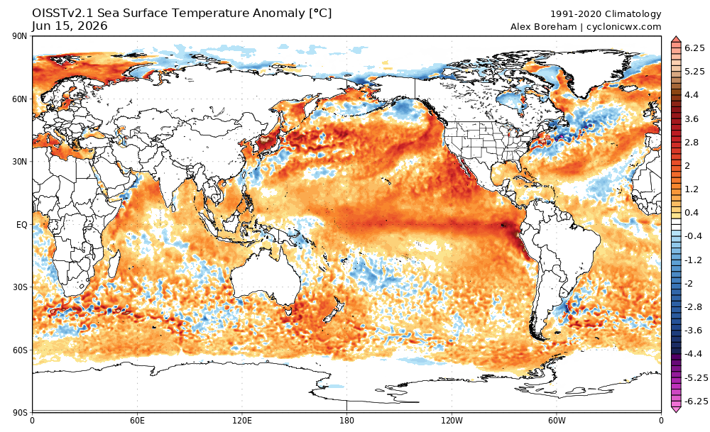
2026-2027 Super El Nino
40/70 Benchmark replied to Stormchaserchuck1's topic in Weather Forecasting and Discussion
Definitely been a hot month out here...only recently shifted more temperate. -
Between this and the lakes that warm front is definitely getting shunted to the south
-
2026-2027 Super El Nino
40/70 Benchmark replied to Stormchaserchuck1's topic in Weather Forecasting and Discussion
I'll tell you, even if it's warm, I welcome a more active pattern with the El Nino...man, I am so sick of this drought the past few years. Even last winter was dry...there was only decent snow because it was so cold...precip was below average and there weren't many coastals. -

Central PA Summer 2026 Discussion/Obs Thread
Itstrainingtime replied to Voyager's topic in Upstate New York/Pennsylvania
He is VERY good if not a little over the top arrogant. You know, we've had 3 separate severe threats over the past week - last Friday, Sunday, and tomorrow. SPC was gung ho on Friday and tomorrow and not so much on Sunday's threat. Elliott was completely out for last Friday which ended up being a total non-event, he was in on Sunday which ended up producing a Tornado in Lancaster county, and he's been out for tomorrow since last weekend even as SPC had us in a rare 6 day outlook. Tomorrow hasn't happened yet but over the past week he seems to be outperforming the big boys at SPC. -

Central PA Summer 2026 Discussion/Obs Thread
mahantango#1 replied to Voyager's topic in Upstate New York/Pennsylvania
This is from a weathersite on Facebook: 11 CONFIRMED TORNADOES IN PENNSYLVANIA Apologies for any wrong/outdated information, as the tornado reports aren't consistent between the SPC/NWS sites, but here is what I found on the 11 reported tornadoes from the severe weather outbreak on Sunday, June 14th. There may be more tornadoes confirmed and/or ratings adjusted as the surveys continue into today. The National Weather Service has confirmed 11 tornadoes across Pennsylvania so far, including 7 EF1 tornadoes, 3 EF0 tornadoes, and 1 tornado still awaiting a final damage survey rating. Confirmed tornadoes occurred in parts of Crawford, Warren, Potter, Jefferson, Clinton, Butler, Beaver, and Lancaster Counties. Blooming Valley — EF1 Grand Valley — EF1 Homer Township — EF0 Big Run — EF1 Pine Glen — EF1 WSW of West Liberty — EF1 ESE of West Liberty — EF0 West Mayfield — EF0 Cannelton (touchdown in OH, moved into PA) — EF1 Kirkwood — EF1 Worthville — EF Rating TBD Stay tuned for updates! -
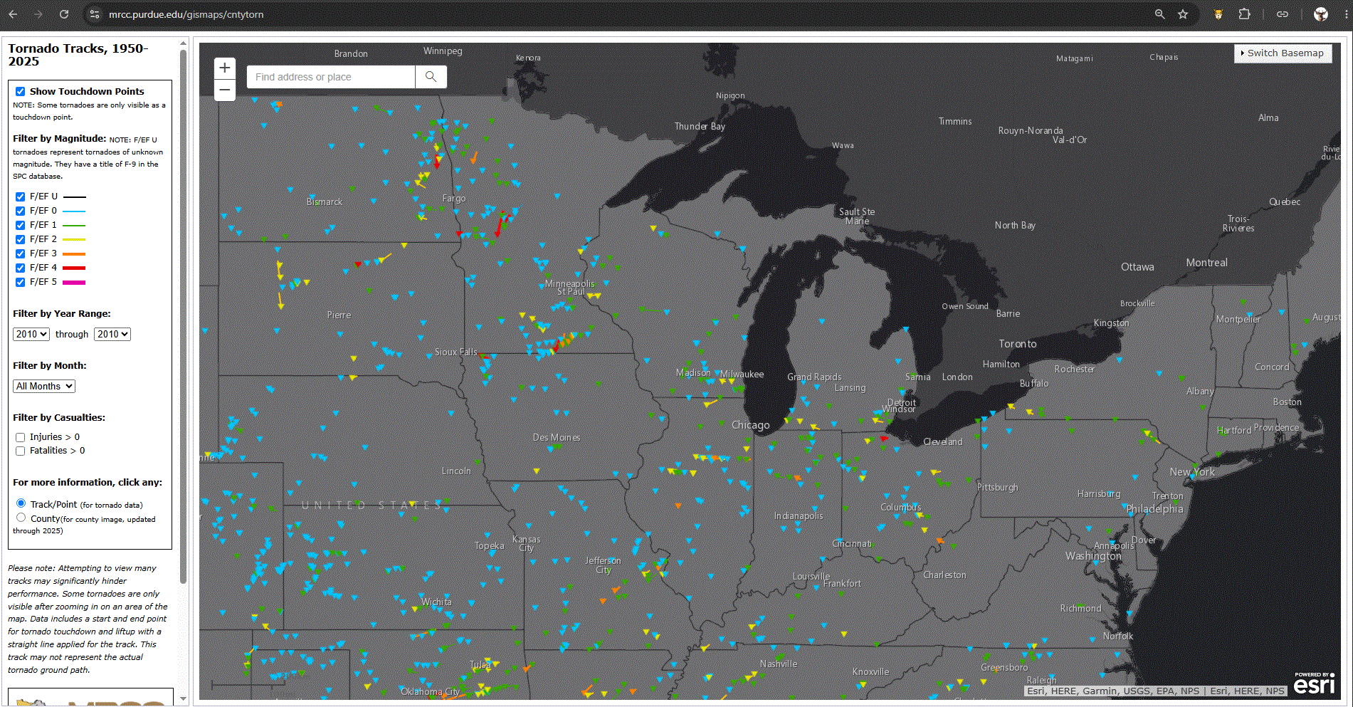
June 17 2010: The largest single-day tornado outbreak in Minnesota history occurs with 48 tornadoes across the state. This outbreak would set the stage for a record breaking tornado year in Minnesota that finished with 113 tornadoes, the most of any state in the US that year. There were three EF-4 tornadoes and four EF-3 tornadoes in Minnesota. Four tornado fatalities occurred, which was the highest daily number since July 5, 1978. (Note: Very impressive record, and quite unusual.) For Wednesday, June 17, 2026 1859 - Hot Santa Ana winds in southern California roasted fruit on one side at Santa Barbara. (Sandra and TI Richard Sanders - 1987) 1882 - A tornado traveled more than 200 miles across the state of Iowa killing 130 persons. The tornado touched down about ninety miles west of Grinnell, and struck the town and college around sunset, killing sixty persons, and causing more than half a million dollars damage. Traveling at nearly 60 mph, the tornado hit Mount Pleasant about 11 PM causing another half a million dollars damage. (David Ludlum) 1965 - Holly, CO, was deluged with 11.08 inches of rain to establish a state 24 hour rainfall record. (The Weather Channel) 1987 - Thunderstorms produced severe weather in the south central U.S. Thunderstorms in Kansas produced wind gusts to 76 mph at Lyons, and baseball size hail at Garden City. The Edwards Aquifer, which supplies water to San Antonio, TX, reached a record level of 699.2 feet following a record 18.43 inches of rain in thirty days. Torrential rains between the mid May and mid June sent 8.8 million acre feet of water down the rivers of southern Texas, the largest volume in 100 years of records. (The National Weather Summary) (Storm Data) 1988 - Thunderstorms produced large hail and damaging winds in Georgia and the Carolinas. Thunderstorm winds gusted to 75 mph at Eden, NC. (The National Weather Summary) (Storm Data) 1989 - Unseasonably cool air, responsible for 37 record lows in the central U.S. on the 15th and 16th, including a low of 33 degrees at Valentine NE on the 15th, overspread the eastern U.S. ending a three day siege of severe weather. (The National Weather Summary) Observances: 17 Wed World Day to Combat Desertification and Drought 17 Wed Bunker Hill Day 17 Wed Clean Your Kitchen Vents Day 17 Wed Gerald Day 17 Wed National Dump the Pump Day 17 Wed National Harrison Day 17 Wed National Jan Day 17 Wed National Ralph Day 17 Wed National Stewart’s Root Beer Day 17 Wed Nursing Assistants Day 17 Wed World Tessellation Day 17 Wed National Apple Strudel Day 17 Wed Global Garbage Man Day 17 Wed National Eat Your Vegetables Day 17 Wed National Mascot Day
-
Yeah.. this is what I was suggesting to you yesterday ... there's a warm boundary that the Euro and GFS are less coherently defining. The NAM on the other hand is kinking the PP enough to suggest a triple point goes underneath Logan. I have seen both scenarios verify in situations like this. I am not presently seeing anything that argues for either. About split.
-
mm... this doesn't lower the value nor significance of the statistical correlation - which is synoptic/ holistic in scale. Not a discrete convective level/meso analysis/indicator. Which there are no known telecons that can be that predictively discrete. For obvious reasons... The point is that the set ups tend to move that incremental spatial-temporal range in the 24 hour window. Hell, not every +PNA/-NAO creates a winter storm here, either, and that's dealing with scales that are far more obvious to the physics.
-
Yeah it's often confusing for the general public... All too often you'll read a forecast such as " A 40% chance of showers and thunderstorms, mostly sunny with a high of 85". Don't even have a decent forecast discussion anymore to clear things up.
-
Showers this morning here with a T in town so far, but NC MN got a bit more and they need it being in a D2 drought. Hoping for a wet day across the area. Will be chilly along the shore with NE winds off the Lake. Highs upper 50's/low 60's.
-
I mean 81 instead of 85 so not exactly cold
-
Don't think many anticipated the wind aspect to be as impressive as it was with the morning MCS out in Iowa. The areas hit hardest had dews in the upper 40s/lower 50s shortly before being hit by it. Very impressive. Gonna get sort of some comma head action here, but no severe worries. Think our severe threat is cooked here, as redevelopment later today will be south/southeast of the area.
-
I've received another 2.1" of rain this morning. This puts June over 8". We are really getting clobbered this month.
-
Must be nice.
-
They might as well have put in the shrugging emoji.
-
A cold very foggy morning this morning. Had a low of 51 degrees this morning and about 50 feet of visibility coming off the mountain.
-
Anyone see the NYC point and click forecast from Upton for tomorrow: Showers likely, with thunderstorms also possible after 2pm. Cloudy through mid morning, then gradual clearing, with a high near 86. Seems a bit confusing, or is it just me?
-
it’s over up north.
-
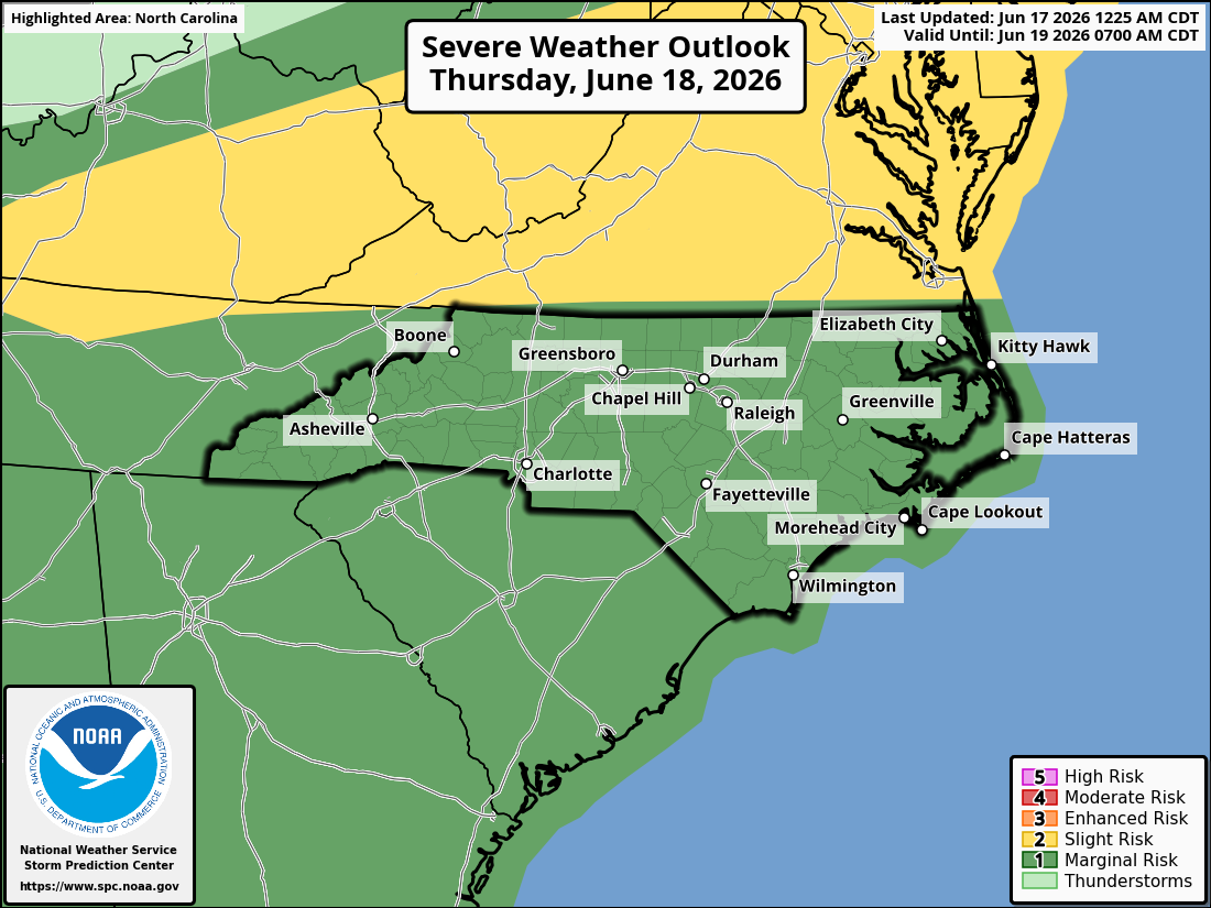
SPC knows the NC wall of dry air

-
60 mph is pretty common in severe storms. 74+ mph is not super rare, but it's much less common.
-

Potential Tropical Cyclone One
WxWatcher007 replied to WxWatcher007's topic in Tropical Headquarters
Yeah odds don't seem great after that recon flight. -
Saw a gust to 94 reported a little earlier to your west. How frequently do you guys get gusts 74+ out there?
-
Looks like those poor midwesterners are gonna get hit with everything but the kitchen sink today. 2000-3000 j/kg yikes.
-

2026-2027 Super El Nino
bluewave replied to Stormchaserchuck1's topic in Weather Forecasting and Discussion
The thing to watch for in July is how much the warm pool near Japan driving the -PDO interacts with the +PMM. The models runs in late June will give us some clues. Could be another overlapping pattern with some Nino-like and Niña-like influences to 500 mb pattern for North America.
-
Doubt it but today should be nice regardless out there. Destructive tag on that latest severe thunderstorm warning out in Iowa. As for here, expectations kept in check for tomorrow. Not expecting much down this way. Whatever ejects out of the Midwest this weekend looks modestly intriguing.