All Activity
- Past hour
-
0.79" out here. Models were showing around 0.80", so right in line with expectations. Beautiful day today and weekend looking better as well
-
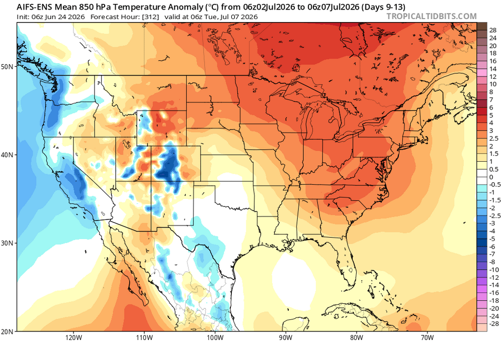
There’s definitely a weakness there with the ridge axis that far west to sneak some north Atlantic stank our way. 00z euro op is definitely a way to taint the heat in our region…like you said. With that said…the ridging won out in early June so I won’t buy that yet. But we’ll be prone to backdoors or at least late digging s/w’s north of us that at least bring the dews down and moderate the heat. I’ve actually been enjoying the last few days. As long as mins are well into the 50s I’m okay with daytime 70s…even for my heat loving plants.
-
That was definitely cheesy...and the trailing car getting sucked away...reminded me of when you would get sucked up by that sun in Super Mario 3
-
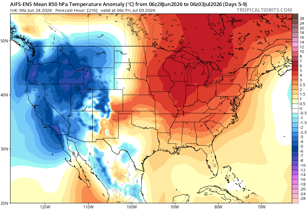
I'm not too keen on persistent heat in the NEUS. 00Z ECMWF says no go. The ridge axis is well to the W so that makes NEUS susceptible to BDFs/onshore flow/more clouds/pcpn. GFS says yes to big heat tho but even that suggests it won't last. Mean trough position near/along the E Coast has been tough to shake overall.
-
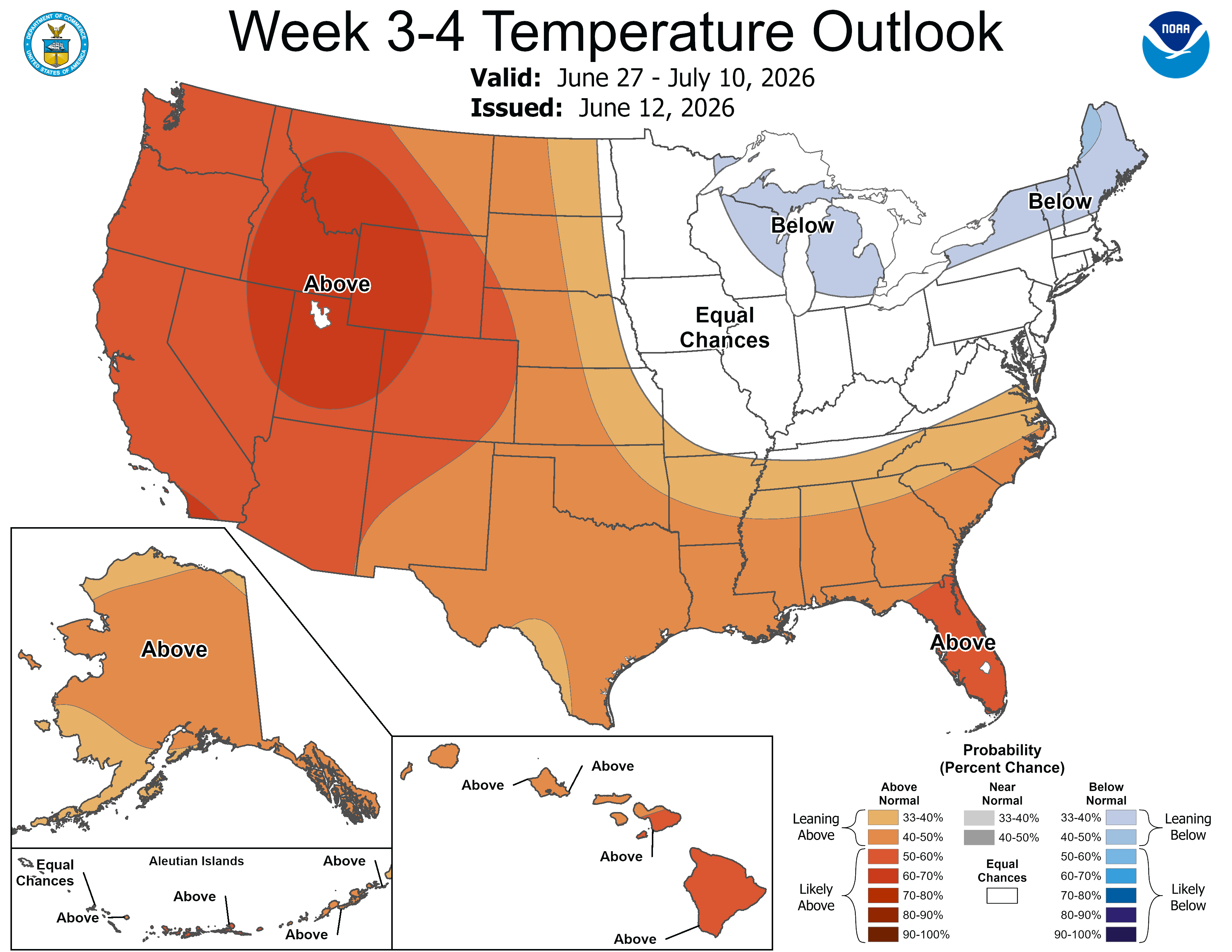
This outlook may turn into TP for the Midwest and Lakes.

-

Central PA Summer 2026 Discussion/Obs Thread
mahantango#1 replied to Voyager's topic in Upstate New York/Pennsylvania
From Facebook: ** RING OF FIRE PATTERN ** Who's ready for the 'ring of fire' pattern next week? A large heat dome will set up in the Ohio Valley, bringing in the high heat and humidity. Even though we will be on the edge of this heat, we will still have temperatures and humidity levels push well above average, with dew points likely into the 70s (oppressive) range. Depending on the exact position of this high-pressure system, we may also be in the axis for storm clusters to move around this ridge of high pressure, which gives this the name 'ring of fire'. These storm clusters will need to be watched, as they will be moving into areas of very high instability and elevated wind shear. It is possible that if this ridge expands, it would push the storm complexes more into New England than into Pennsylvania. Regardless, next week will be rather active between the heat and storm potential! #PAwx #Pennsylvania #June #July #Summer #HeatDome -
everyone is tracking the extreme heat dome in Europe
-
I would like to see the airshow in Baltimore on Sunday and go to the National Zoo on Saturday. I vote for delaying it two days!
-

2026-2027 Super El Nino
GaWx replied to Stormchaserchuck1's topic in Weather Forecasting and Discussion
If this were to keep up, the WCS daily PDO will go positive at least for a short period starting by ~this weekend! It’s now up to -0.17 vs -1.40 on May 27th: The last times this was + were ~5 days in March-April of 2025!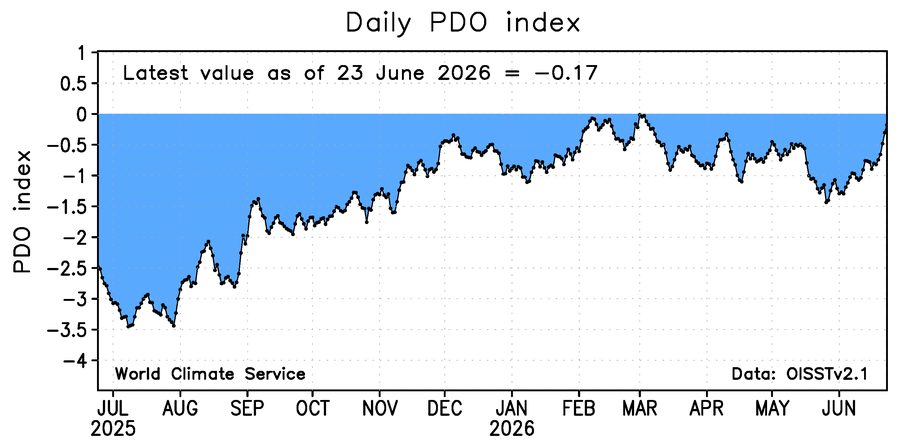
-

2026-2027 Super El Nino
FPizz replied to Stormchaserchuck1's topic in Weather Forecasting and Discussion
Yes, only this site. -

Wet late Monday 6/22 or another Fizzle?
MN Transplant replied to Weather Will's topic in Mid Atlantic
Two-day totals via CoCoRahs. Despite this, almost everyone is sub-3" for the month so far.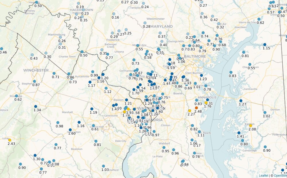
-
2026-2027 Super El Nino
GaWx replied to Stormchaserchuck1's topic in Weather Forecasting and Discussion
Is anyone else intermittently seeing “bad gateway” error code 502 messages and sometimes having trouble with long delays in reading and posting with it saying the problem is with the host, AmericanWx BB? I’m not seeing this with any other sites. -
Reed Timmer movie Aug 23. https://www.youtube.com/watch?v=eEiy7y1ETF8 I don't deny that he doesn't get great video, but the caviler and reckless attitude I have issues. Many get the idea that storm chasing is easy and anyone can do it, which is not true, at least from a safety and responsible POV. This is a skewed presentation of how it really is. The trailer is about as cliche and formulaic as you can get. And what does jogging in slow motion have to do w/ storm chasing? Talk about an intro that has been done 1000x over. That's the best they could do for an intro? And as if storm chasing has not been dramatized and romanticized enough already? I fear the roads next spring. We keep thinking, "how can it get worse?" and then witness another year. And if this movie does very well? You can expect a flood of more wx movies, some downright egregious, as everyone tries to cash in on the renewed fad/novelty. Recall what we saw after "Twister" in 1996? We got "Night of the Twisters" and "Tornado," and it seemed every popular show on TV at the time had to insert a tornado into the plot!
-
Yes, it is based on the June 3, 1980 Grand Island NE event (look it up, PT material for sure). It was awesome? How did you like the anticyclonic hurricane over Nebraska as what the storm looked like? And the "chase" scene or the climax is the apex of cheesy silly (tornado "following" the family in their car). At least "Twister" tried. It has some issues, but I can forgive for artistic license to a point, as it is for entertainment. For a wx movie, it was about as good as you make one IMHO w/o going off the rails silly/stupid!
-
Missed out on any rain yesterday, and now only scattered rain possible today. Currently raining up N. A cool day on tap with highs in the 60's.
-

Mountain West Discussion
mayjawintastawm replied to mayjawintastawm's topic in Central/Western States
Smoke was a big inhibitor of heating yesterday along the central and northern Front Range/Urban Corridor, so storms never popped locally even when the outflows from the other storms moved through. Cap for the win. Hopefully today will be different (though I certainly don't need 2" hail!) - Today
-
June 24 2002: Heavy rains fall on already saturated ground, leading to flooding. 5.50 inches fall at Delano, and half of a mobile home park at Howard Lake is evacuated due to rising water. 1972: Frost develops across northeast Minnesota. Duluth has a low of 35 and Tower bottoms out at 32. (Note: We've seen similar temps already this year in late June in NE MN.) For Wednesday, June 24, 2026 1816 - The cold weather of early June finally gave way to several days of 90 degree heat in Massachusetts, including a reading of 99 degrees at Salem. (David Ludlum) 1924 - Six men at a rock quarry south of Winston-Salem, NC, sought shelter from a thunderstorm. The structure chosen contained a quantity of dynamite. Lightning struck a near-by tree causing the dynamite to explode. The men were killed instantly. (The Weather Channel) 1951 - Twelve inches of hail broke windows and roofs, and dented automobiles, causing more than fourteen million dollars damage. The storm plowed 200 miles from Kingmand County KS into Missouri, with the Wichita area hardest hit. It was the most disastrous hailstorm of record for the state of Kansas. (David Ludlum) 1952 - Thunderstorms produced a swath of hail 60 miles long and 3.5 miles wide through parts of Hand, Beadle, Kingsbury, Miner and Jerauld counties in South Dakota. Poultry and livestock were killed, and many persons were injured. Hail ten inches in circumference was reported at Huron SD. (The Weather Channel) 1987 - Thunderstorms spawned six tornadoes in eastern Colorado. Baseball size hail was reported near Yoder, CO, and thunderstorm winds gusting to 92 mph derailed a train near Pratt, KS. The town of Gould, OK, was soaked with nearly an inch and a half of rain in just ten minutes. (The National Weather Summary) (Storm Data) 1988 - Forty-three cities reported record high temperatures for the date. Valentine NE reported an all-time record high of 110 degrees, and highs of 102 degrees at Casper, WY, 103 degrees at Reno, NV, and 106 degrees at Winnemucca, NV, were records for the month of June. Highs of 98 degrees at Logan, UT, and 109 degrees at Rapid City, SD, equaled June records. Lightning killed twenty-one cows near Conway, SC. (The National Weather Summary) (Storm Data) 1989 - Thunderstorms developing along a warm front produced severe weather from Colorado and New Mexico to Kansas and Nebraska. Thunderstorms spawned seven tornadoes, and produced wind gusts to 80 mph at Wood River, NE, and hail three inches in diameter at Wheeler, KS. (The National Weather Summary) (Storm Data) Observances: 24 Wed National Swim A Lap Day 24 Wed Farmer Day 24 Wed Fix Your Windows and Doors Day 24 Wed International Fairy Day 24 Wed International St. Johns Day 24 Wed Midsummer 24 Wed National Le Day 24 Wed National Pralines Day 24 Wed National Relationship Equity Day 24 Wed Upcycling Day
-
I would have received 10" of snow, no complaints. 1.01" in Syosset & 1.00" in Muttontown from the storm.
-
Radar estimates were ridiculously overdone. 1” where radar said there was 2.5”. So really not much help overall.
-
Night of the Twisters was awesome, read the book too. But, wasn't this based on a "true" event? And I say "true" because the specifics/details weren't exactly based on reality but the background of the event was
-
I’ve seen that image before. I’ll expect the under.
-
I didn't even notice that Sounds like how watches work in Canada
-
WxWiz will buy his tickets 1201am the day they go on sale and make sure he is first in line at his locate AMC! Opens Aug 21. https://www.youtube.com/watch?v=eEiy7y1ETF8 The trailer is about as cliche and formulaic as you can get. And what does jogging in slow motion have to do w/ storm chasing? Talk about an intro that has been done 1000x over. That's the best they could do for an intro? And as if storm chasing has not been dramatized and romanticized enough already? I fear the roads next spring. We keep thinking, "how can it get worse?" and then witness another year. And if this movie does very well? You can expect a flood of more wx movies, some downright egregious, as everyone tries to cash in on the renewed fad/novelty. Recall what we saw after "Twister" in 1996? We got "Night of the Twisters" and "Tornado," and it seemed every popular show on TV at the time had to insert a tornado into the plot!
-

Occasional Thoughts on Climate Change
Typhoon Tip replied to donsutherland1's topic in Climate Change
By some small added amount... (if otherwise determined less significant, notwithstanding) this heat wave in N-W Europe is plausibly made fractionally worse by the fact that it's straddling the Solstice. The idea being obvious, the sun surround this week to 10 days perennially reaches it's most intensity relative to all N. Hemispheric latitudes. July heat waves are within the solar Max period of the year, ~ May 10 to August 10... Not sure if this is a threshold argument, to be fair. Like it doesn't matter for solar flux variances when above a certain value, as long as the region is above that seasonal value, the heat response is the same. I'm not sure that makes physical sense because you are either dumping more, or less actual solar radiation into the system - The other complexity is 'prompting' overlapping with circulation modes of mid summer that are concurrent by July 20th.. Prompting comes from a kind of "non-Markovian" aspect of the hemisphere (Non-Markovian refers to systems where the future state depends not only on the current state but also on past states, indicating the presence of memory effects in the dynamics of the system... ) So, that kind of trades off a slightly lowering solar rad count for the fact that the system is bias to get back to warmer states. The circulation mode addition is that the normal seasonal expansion of the HC and polarward retreat of the westerlies --> the apex in seasonal-climate for heat reaching it's farthest N latitudes. If 1 and 2 are constructively interfering ... it may be worth it to take a linear look at the statistics over the years, and see if there is a tendency to heat repeating when May/June are significantly above average. That's the science approach... intuitively? mmm we're doing that ( plausibly) when holistically ...the world is constructively interfering with any excuse to be warm at all. All of which begins to fade off circa mid August. At which time solar dimming becomes significant enough that it just doesn't add as much, or enough to recover a hot hemisphere - prompting can't actually do it alone, and ambient troposphere begins to shrink (albeit less coherently at first) from losing diurnal thermal pressure. So a short version take away... You know, I can already see that D4 the the heat has relaxed due to downward/relaxation in the present circulation mode from the middle Atlantic Basic to Scandinavia. However, all the ensemble main sources, EPS/GEFS/GEPS are more and less coherently already showing by 200 hours that a new ridge may be formulating W of the Iberian Peninsula. That essence tends to presage a correction as the times near to go ahead and balloon that feature N-E to engulf as far N as the lower B.I region ... perhaps a resurgence is in the making. -
Last year at this time my yard was full of lantern flies. Now none. Did our brutal winter destroy them?