All Activity
- Past hour
-
BULLETIN - IMMEDIATE BROADCAST REQUESTED Severe Thunderstorm Warning National Weather Service Baltimore MD/Washington DC 809 AM EDT Thu Jun 18 2026 The National Weather Service in Sterling Virginia has issued a * Severe Thunderstorm Warning for... Northwestern Rockingham County in western Virginia... Northwestern Augusta County in western Virginia... Highland County in western Virginia... Pendleton County in eastern West Virginia... * Until 845 AM EDT. * At 809 AM EDT, severe thunderstorms were located along a line extending from 15 miles west of Upper Tract to 9 miles east of Richwood, moving east at 65 mph. HAZARD...60 mph wind gusts. SOURCE...Radar indicated. IMPACT...Damaging winds will cause some trees and large branches to fall. This could injure those outdoors, as well as damage homes and vehicles. Roadways may become blocked by downed trees. Localized power outages are possible. Unsecured light objects may become projectiles. * Locations impacted include... Franklin, Monterey, Brandywine, Upper Tract, Doe Hill, Head Waters, Riverton, Deer Run, Liberty, Circleville, Ruddle, Williamsville, Oak Flat, Vanderpool, Sirons Mill, Hightown, Clover Creek, Cherry Grove, Mill Gap, and New Hampden.
-
BULLETIN - IMMEDIATE BROADCAST REQUESTED Severe Thunderstorm Warning National Weather Service Baltimore MD/Washington DC 806 AM EDT Thu Jun 18 2026 The National Weather Service in Sterling Virginia has issued a * Severe Thunderstorm Warning for... Southwestern Allegany County in western Maryland... Northwestern Rockingham County in western Virginia... Northeastern Pendleton County in eastern West Virginia... Grant County in eastern West Virginia... South central Mineral County in eastern West Virginia... Western Hardy County in eastern West Virginia... Southwestern Hampshire County in eastern West Virginia... * Until 830 AM EDT. * At 806 AM EDT, severe thunderstorms were located along a line extending from near Keyser to 6 miles east of Davis to 8 miles south of Hendricks, moving east at 65 mph. HAZARD...60 mph wind gusts. SOURCE...Radar indicated. IMPACT...Damaging winds will cause some trees and large branches to fall. This could injure those outdoors, as well as damage homes and vehicles. Roadways may become blocked by downed trees. Localized power outages are possible. Unsecured light objects may become projectiles. * Locations impacted include... Keyser, Moorefield, Petersburg, Romney, Rough Run, Upper Tract, Burlington, Russelldale, Landes, Arthur, Brushy Run, New Creek, Seymourville, Lahmansville, Masonville, Cabins, Dorcas, Fisher, Medley, and Kline Gap. PRECAUTIONARY/PREPAREDNESS ACTIONS... For your protection move to an interior room on the lowest floor of a building.
-
Seems a higher percentage play at your latitude from what I have gathered.
-
A trace so far. The line out by Davis is looking more robust that the models have it, so maybe it can power through to give us at least a little rain.
-
I’m taking the severe risk today legitimately; seems we have all the general players positioned very well. Pretty textbook. Just need to have a good sky clearing after this current round of downpours.
-
Convection just doesn't do much for me because the odds of anything noteworthy at any given location is just so low........I mean, what are the odds one of those rogue cells sets up over MBY....and furthermore, what are the odds said rogue cell offers anything more anomalous than some heavier rain and gusty winds. While the jackpot is inherently elusive, at least during major winter storms the noteworthy significant blanket of snowfall is pretty uniform. That is a worthwhile endeavor relative to the ill-fated summer rendition of pin the convective tail on the weenie.
-
Here in the seacoast region of NH I’ve learned to take a negative bias for surface based forcing and a significant positive bias for mid level forcing. It didn’t come easy—many beatings—thanks to model guidance hoodwinking on days the sensible weather feels primed for severe…
-
985 mb near Montreal is pretty damn impressive for mid June climo
-
Since this drought started back in Sept 2024, my station is some 28" below normal.
-
Yeah I’m with you there.
-
Especially for convection. I’m more excited when Ray gets 20” and I get 2” vs convection around these parts. Unless it’s a locked in deal.
-
I'm the same, completely, except for hurricanes.
-
BULLETIN - IMMEDIATE BROADCAST REQUESTED Severe Thunderstorm Warning National Weather Service Baltimore MD/Washington DC 755 AM EDT Thu Jun 18 2026 The National Weather Service in Sterling Virginia has issued a * Severe Thunderstorm Warning for... Southwestern Garrett County in western Maryland... Northwestern Pendleton County in eastern West Virginia... Central Grant County in eastern West Virginia... * Until 830 AM EDT. * At 755 AM EDT, severe thunderstorms were located along a line extending from near Bayard to 6 miles southeast of Hendricks to near Elkins, moving east at 60 mph. HAZARD...60 mph wind gusts. SOURCE...Radar indicated. IMPACT...Damaging winds will cause some trees and large branches to fall. This could injure those outdoors, as well as damage homes and vehicles. Roadways may become blocked by downed trees. Localized power outages are possible. Unsecured light objects may become projectiles. * Locations impacted include... Streby, Seneca Rocks, Onego, Hopeville, Beechwood, Riverton, and Wilsonia.
-
While I can watch footage of impressive events for severe and snow, if it’s not near my backyard….tough for me to really be excited. As Felger would do…”finger in mouth” pop…whee..yay!!
-

Central PA Summer 2026 Discussion/Obs Thread
mahantango#1 replied to Voyager's topic in Upstate New York/Pennsylvania
From the looks on the radar, looks like i'll be missing out on the rain today. My June rainfall total for the month is .98. We need some beneficial rain very soon. -

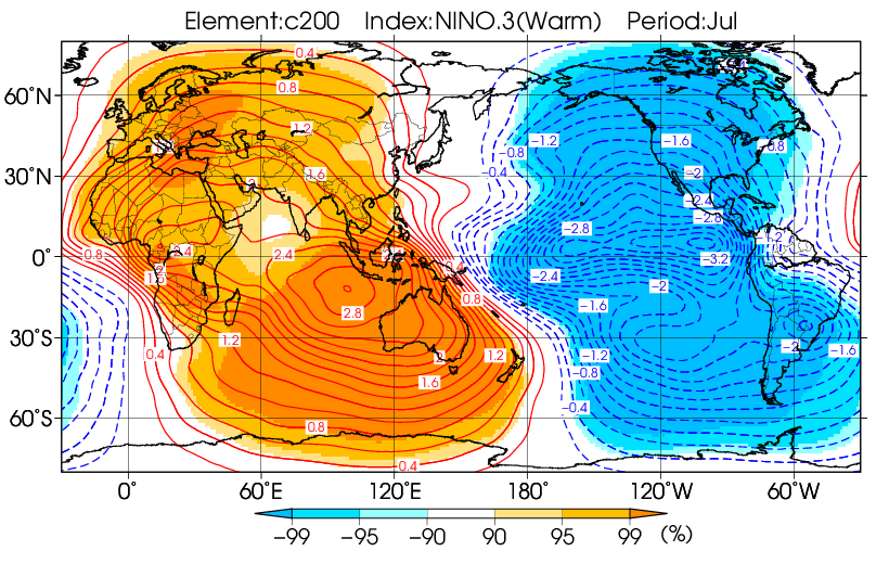
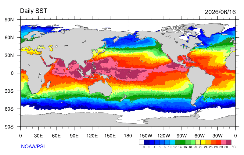
2026-2027 Super El Nino
bluewave replied to Stormchaserchuck1's topic in Weather Forecasting and Discussion
Forcing extending back to the WPAC warm pool as we approach early July may result in more Niña-like elements than we typically see with super El Niños continuing. This has been the case during the spring into summer so far with the record 30 C warm pool. So we can see overlapping influences continue with the North American pattern.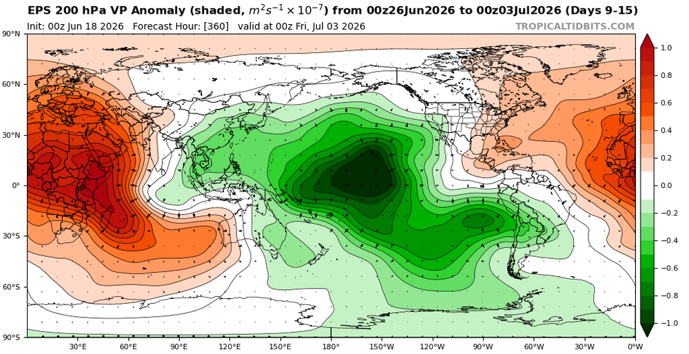
-

2026 Mid-Atlantic Severe Storm General Discussion
JenkinsJinkies replied to Kmlwx's topic in Mid Atlantic
It’s overcast now, overcast mornings are the kiss of death for severe threats.- 784 replies
-
- 1
-

-
- severe
- thunderstorms
- (and 7 more)
-
A true, old-fashioned soaker this morning. The radar, to my delight, looks like a traffic signal. So far, 1.29" of rain has fallen with ongoing storm intensity of around an inch per hour. With the wind advisory kicking in soon, I hope any tree damage is minimal.
-

2026 Mid-Atlantic Severe Storm General Discussion
AmericanWxFreak replied to Kmlwx's topic in Mid Atlantic
So can we start talking about today’s weather now? lol . -
Lovers' quarrel?
-
Sucks im not home for this one.. best of the season?
-
can't wait for my passing shower later that amounts to <0.03"
-
I need the rain desperately...hopefully some big storms pop up here.
-
Pleasant surprise to see rain this am! Will take every drop....radar looks much better than I expected!!!
-
BULLETIN - IMMEDIATE BROADCAST REQUESTED Severe Thunderstorm Warning National Weather Service Baltimore MD/Washington DC 737 AM EDT Thu Jun 18 2026 The National Weather Service in Sterling Virginia has issued a * Severe Thunderstorm Warning for... Southwestern Garrett County in western Maryland... Northwestern Grant County in eastern West Virginia... Southwestern Mineral County in eastern West Virginia... * Until 800 AM EDT. * At 737 AM EDT, a severe thunderstorm was located 7 miles northwest of Bayard, moving east at 60 mph. HAZARD...60 mph wind gusts. SOURCE...Radar indicated. IMPACT...Damaging winds will cause some trees and large branches to fall. This could injure those outdoors, as well as damage homes and vehicles. Roadways may become blocked by downed trees. Localized power outages are possible. Unsecured light objects may become projectiles. * Locations impacted include... Mountain Lake Park, Oakland, Bayard, Loch Lynn Heights, Deer Park, Redhouse, Hutton, Gorman, Crellin, Beechwood, Wilson, Gormania, and Wilsonia. PRECAUTIONARY/PREPAREDNESS ACTIONS... Remain alert for a possible tornado! Tornadoes can develop quickly from severe thunderstorms. If you spot a tornado go at once into the basement or small central room in a sturdy structure. For your protection move to an interior room on the lowest floor of a building. && LAT...LON 3942 7948 3944 7920 3921 7932 3921 7936 3919 7949 TIME...MOT...LOC 1137Z 273DEG 51KT 3931 7949 TORNADO...POSSIBLE HAIL THREAT...RADAR INDICATED MAX HAIL SIZE...<.75 IN WIND THREAT...RADAR INDICATED MAX WIND GUST...60 MPH


.thumb.JPG.418e8a9a2902ae687ec35ff4bc0e038e.JPG)


