All Activity
- Past hour
-
Would get me out of my chem exam the 3rd so I’m happy with it
-
It continues with the same idea. All that matters on an op run at this range.
-

Winter 2025-26 Medium/Long Range Discussion
Frog Town replied to michsnowfreak's topic in Lakes/Ohio Valley
Weather history buffs, help me out here. It was early December 2000, and we had a setup similar to what we’re seeing now—a hybrid-type low dropping out of Alberta. It was originally forecast to behave a lot like this weekend’s storm, but instead it tracked farther south and nailed Ohio and southern Michigan. I had just graduated college and remember being caught off guard by the shift. Ironically, that December ended up being one for the books, turning into one of the coldest and snowiest on record for these parts. Thanks for starting the thread, Michsnowfreak. -
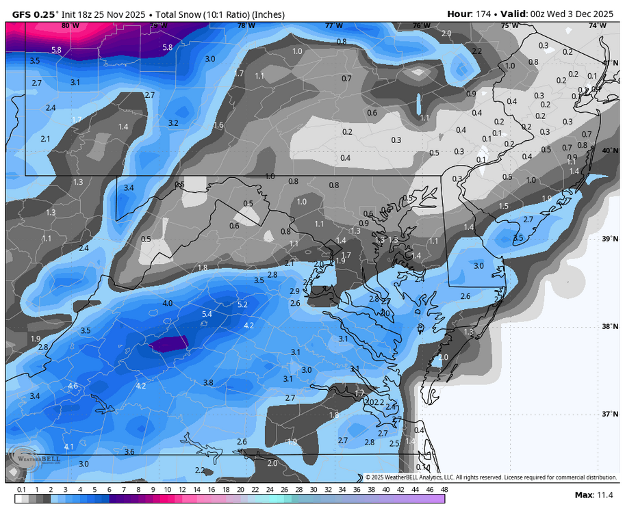
18z GFS is actually pretty nice. Nov 30 flurries + ice and then 1-3", even more points south of DC
-
Ray puts a shit ton of effort into those outlooks. Probably better than most established Mets doing long range louooks.
-
It’s a hit - least a modest one
-
Looks like 18z GFS while giving us a bit of ice with the system before the 3rd might shear out the 3rd system
-

Nov 28-30th Post Turkey Day Wintry Potential
ChiTownSnow replied to Chicago Storm's topic in Lakes/Ohio Valley
with that lead wave, what are we talking on ratio's ? -
yeah it's usually one or the other for good conditions-I'm in Breck 1st week of Feb so hoping it's ok by then
-

Nov 28-30th Post Turkey Day Wintry Potential
migratingwx replied to Chicago Storm's topic in Lakes/Ohio Valley
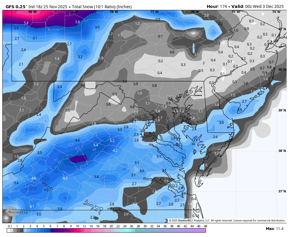
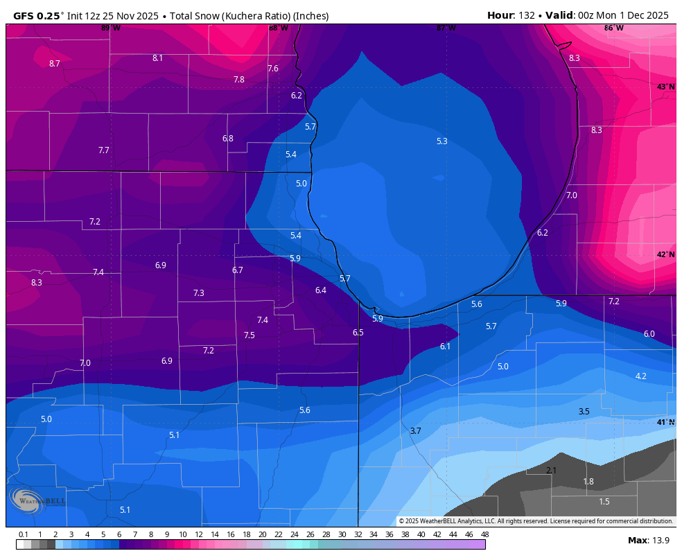
18Z GFS has slightly higher amounts for Chicagoland. 18z vs 12z below.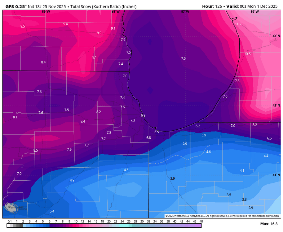

-
Agree... You can't be blamed for being gun shy... Lots of screw jobs over the past few years. That being said, I think optimism is warranted... Since we will be dealing with mainly SWFEs, it would be nice to get some secondary, even weak, lows running out under SNE? I am certainly going to stay conservative, especially SOP, in the short term. Would love to see the pattern morp into one favoring coastal as we move into the heart of the winter; very late Dec onward. For now, Midwest track favored with SWFE causing our main action... Missing out on early December snows doesn't really bother me; I'm just looking for favorable pattern trends. Liking fact 40/70 is bullish in general.
-
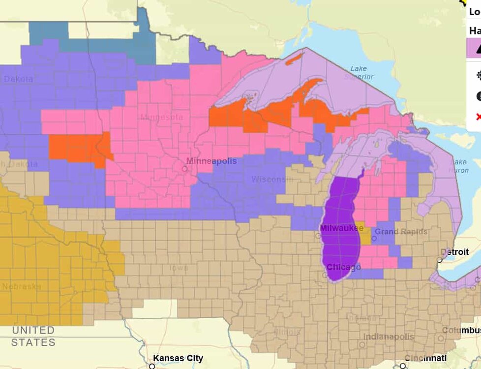
Good to see some colors back on the map
-
LES bands starting form. Getting some snow right now. Little earlier than expected, so possible 6"+ in town is possible.
-
Next Tuesday is looking tantalizingly close.
-
Yes his is stellar. My records started in 1966 and really got going 1980-present . What happened from April into Setptember and what’s been happening last 15 or so days, each with a weighted average. When I find , for example, that May and June with near historically wet then July with very high heat indexes then August dry and normal temps and Nov 1-15 damp dreary snd chilly-what followed all that? When I can find 4 out of 5 matches or 7 out of 10 then I reveal my thoughts I like 12/4-5
-
I haven't received any measurable rain yet. That 3-5" snow here would have required a vivid imagination!
-

December 2025 regional war/obs/disco thread
SouthCoastMA replied to Torch Tiger's topic in New England
8 years since the last above average season here. 1 Average season and 6 below average since. so sick of this sh*t..I'll take average or slightly above at this point -
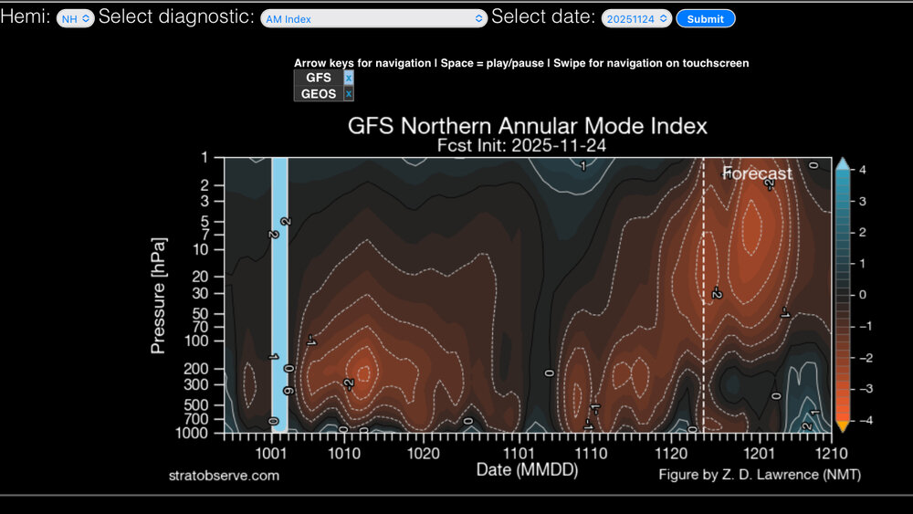
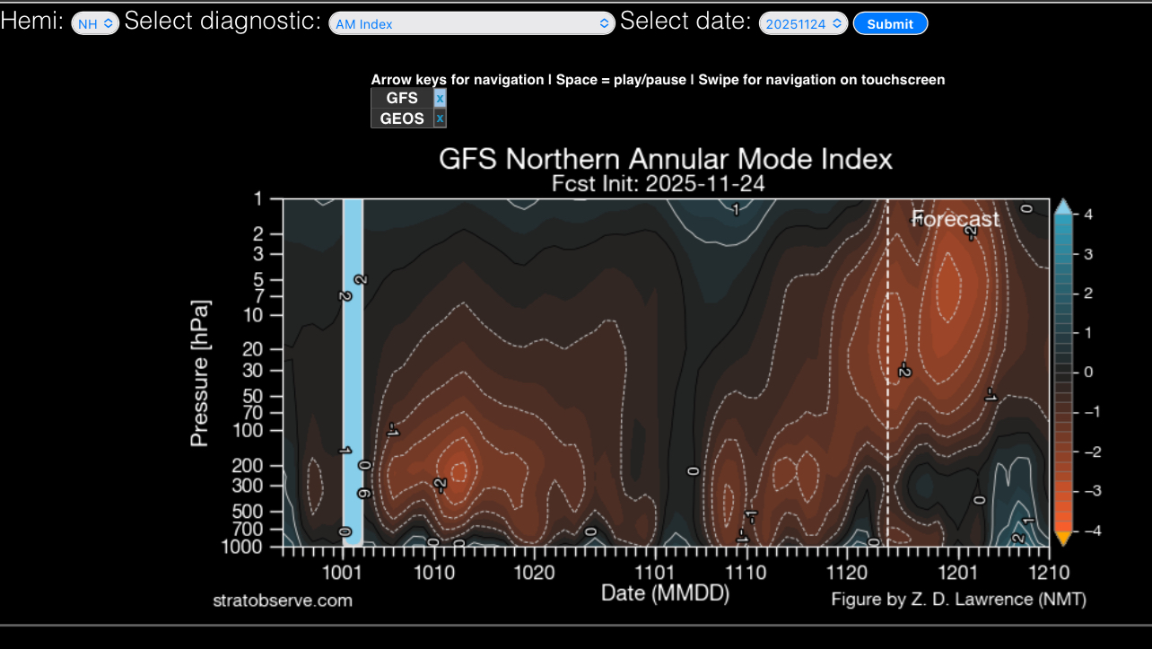
The effects of the SSW look to completely decouple from the surface (for now).
-
This would have been another easy 3-5” snow. Getting precip cored rn. Raw day.
-
That’s how I feel. I’m optimistic, but I can’t help but to always look to see what can go wrong. It’s probably some PTSD lol, but it’s been the reality last few years. 2025 has been the most challenging for me. I could use a good winter stretch.
- Today
-
I hope you have fun with your crowd! I just got back a few weeks ago from looking around the Keewenaw and it's absolutely killing me to miss the blizzard knocking on their doors. Any other time, I'd be on my way there. Crossing my fingers you have enough to play with . I'll wave from Richmond lol.
-
Wow, Pacific pattern is completely different.
-
That's going to be the issue as this pattern unfolds during December. Degree of old loading into southeast Canada will be critical. Too much assist from -NAO and we get suppression; too little and SNE gets screwed by warming, but ice potential increases? But if we get modest confluence locked in by weak to moderate -NAO and it could be a solid December; especially NOP! I would keep expectations low right now, but it's an active look with decent potential.
-

2025-2026 ENSO
Daniel Boone replied to 40/70 Benchmark's topic in Weather Forecasting and Discussion
Yeah, the reflection thing is a concerning Factor for sure. As mentioned earlier, it will make for an interesting forecast period with the MJO in cold Phases. -
Ray's Winter Storm Archive, while focused primarily on New Jersey, is an excellent resource for winter storms during the 1993 - 2013 time frame.


.thumb.jpg.ad3a2e31d30aff035044689b311a0540.jpg)


.thumb.JPG.418e8a9a2902ae687ec35ff4bc0e038e.JPG)

