All Activity
- Past hour
-
Will sunrise not be in the east? Now that would be a huge surprise!
-
Rich get richer.
-

Occasional Thoughts on Climate Change
donsutherland1 replied to donsutherland1's topic in Climate Change
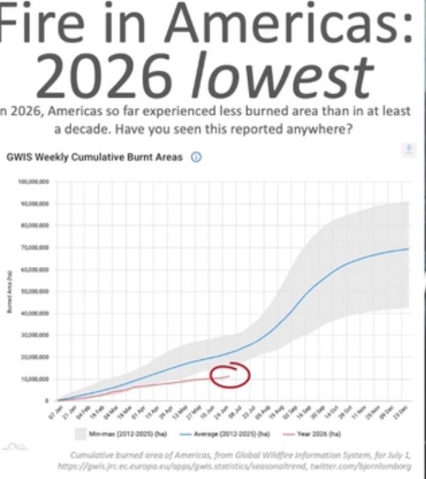
The map is dated. Nevertheless, winter fire activity in South America has so far been largely suppressed by a wetter to much wetter than normal start to winter. The U.S. has seen a fairly sizable pickup in fire activity in late July. -

Dewgust 2026: Summer's Last Stand
VivaManchVegas replied to Prismshine Productions's topic in New England
over preforming here today. 88. Opened up the windows this morning after skunkmagendon. Nice day. Little swampy but enjoy it while it lasts. -
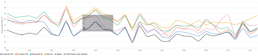
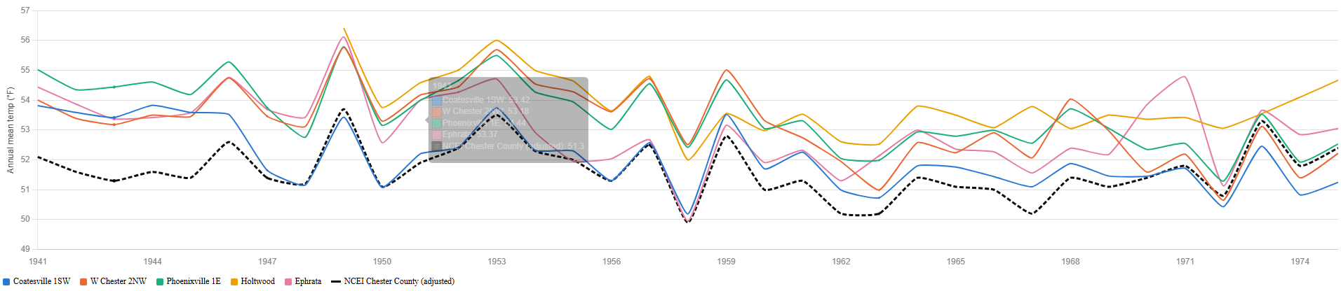
(002).thumb.png.6e3d9d46bca5fe41aab7a74871dd8af8.png) This is a follow up to the earlier Coatesville 1SW review and analysis. The issue surfaced earlier and evaluated further here is to determine if there is support for the NCEI post hoc chilling of all raw data for the consistently reporting Chester County PA stations of Coatesville1SW/ West Chester 2NW and Phoenixville1E from 1941-1975? Keep in mind that without these NCEI chilling adjustments the long-term average annual temperature warming curve for Chester County goes from significant warming based on NCEI adjusted data to clear non statistical warming from 1893 through 2025. So for this pass we went outside of Chester County to find "neighborhood" stations within 30 miles of Coatesville1SW with enough consistent overlapping observations from 1941-1975. We found 6 potential additional “neighborhood” stations but only 2 had enough consistent data Holtwood and Ephrata over the years in question to add to the 3 main Chester County stations above. So what did the analysis find? All 5 raw stations move together in the same years so there is no inconsistent cooling trend based on the raw data across these stations. However, as we have found before - the overall NCEI Adjusted Chester County data while following the raw average temperature pattern consistently applied a solid ~1-2 F post hoc adjustment that was in fact below all 5 raw stations across essentially the entire period! This was a clear offset, not a trend divergence. So again what station if not a neighboring station within 30 miles of Chester County was NCEI using to apply non-stop chilling adjustments to adjust the raw temperatures to even lower levels than they were all showing for all those years? So we know Coatesville 1SW was not adjusted cooler due to Time of Observation bias that was ruled out by majority 8am readings (if anything one could argue for a slight warming adjustment for homogenization) No station moves resulted in significant temperatures changes that were not statistically the same as the other area station trends so we still have no support for the individual Coatesville1SW chilling NCEI adjustments and no support for the overall Chester County historical 1941-1975 chilling adjustments made by NCEI. See chart attached.
This is a follow up to the earlier Coatesville 1SW review and analysis. The issue surfaced earlier and evaluated further here is to determine if there is support for the NCEI post hoc chilling of all raw data for the consistently reporting Chester County PA stations of Coatesville1SW/ West Chester 2NW and Phoenixville1E from 1941-1975? Keep in mind that without these NCEI chilling adjustments the long-term average annual temperature warming curve for Chester County goes from significant warming based on NCEI adjusted data to clear non statistical warming from 1893 through 2025. So for this pass we went outside of Chester County to find "neighborhood" stations within 30 miles of Coatesville1SW with enough consistent overlapping observations from 1941-1975. We found 6 potential additional “neighborhood” stations but only 2 had enough consistent data Holtwood and Ephrata over the years in question to add to the 3 main Chester County stations above. So what did the analysis find? All 5 raw stations move together in the same years so there is no inconsistent cooling trend based on the raw data across these stations. However, as we have found before - the overall NCEI Adjusted Chester County data while following the raw average temperature pattern consistently applied a solid ~1-2 F post hoc adjustment that was in fact below all 5 raw stations across essentially the entire period! This was a clear offset, not a trend divergence. So again what station if not a neighboring station within 30 miles of Chester County was NCEI using to apply non-stop chilling adjustments to adjust the raw temperatures to even lower levels than they were all showing for all those years? So we know Coatesville 1SW was not adjusted cooler due to Time of Observation bias that was ruled out by majority 8am readings (if anything one could argue for a slight warming adjustment for homogenization) No station moves resulted in significant temperatures changes that were not statistically the same as the other area station trends so we still have no support for the individual Coatesville1SW chilling NCEI adjustments and no support for the overall Chester County historical 1941-1975 chilling adjustments made by NCEI. See chart attached.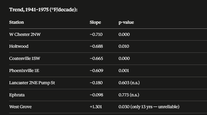
-

2026-2027 Super El Nino
bluewave replied to Stormchaserchuck1's topic in Weather Forecasting and Discussion
The summer of 1987 was only the 6th warmest summer of the 1980s ranking only around the 60th warmest summer average temperature overall for the CONUS since 1895. The warmest summer from that era was 1988 which was the 12th warmest average temperature for the CONUS. While the summer of 1987 was warmer than the 1982 developing super El Nino, the 500mb and temperature pattern from the Pacific to the Atlantic was a general match for El Nino. Even though there was an area of warmer departures relative to the other regions in portions of the East, other areas from the Pacific to Atlantic did match El Nino expectations. Since you can have a good general match without 100% conformity to the El Nino composite. -
-

Central PA Summer 2026 Discussion/Obs Thread
canderson replied to Voyager's topic in Upstate New York/Pennsylvania
It’s miserable in the city. My sweat is sweating. -
Just had some rain while goi g to lodi, nj.
-

-
Yikes
.thumb.png.eb9ce0e4de9025472dd0249750abcdee.png)
-
 DCA: 0.0 NYC: 0.0 BOS: +0.5 ORD: +1.0 ATL: +2.0 IAH: +2.0 DEN: +3.0 PHX: +2.2 SEA: +1.7
 -
SPC has marginal and slight risk out for middle and east tn 5-15% wind and 2% tornado now in Cumberland plateau and parts of east tn as mentioned yesterday .
- Today
-

Dewgust 2026: Summer's Last Stand
Damage In Tolland replied to Prismshine Productions's topic in New England
We named it Augdewst for a reason -
Yes, I’ve been noticing the past two weeks that the sun is setting sooner than mid-June when it was still technically sunny just before an 8:35/8:40 sunset. It’s definitely been noticeable to me over last few weeks, so I even checked on it. Today we are losing 1:54 minutes daily in day length. Beginning August 5 we start losing two minutes of day length daily, which increases gradually over the rest of August, getting up to 2:26 minutes of lost day length by Aug 31. The rate of decreasing daylight starts slowing down, so that by the end of September we are losing “only” 2:32 minutes daily of day length.
-

2026-2027 Super El Nino
GaWx replied to Stormchaserchuck1's topic in Weather Forecasting and Discussion
They are overall although not the BN Arctic interestingly enough. -

2026-2027 Super El Nino
qg_omega replied to Stormchaserchuck1's topic in Weather Forecasting and Discussion
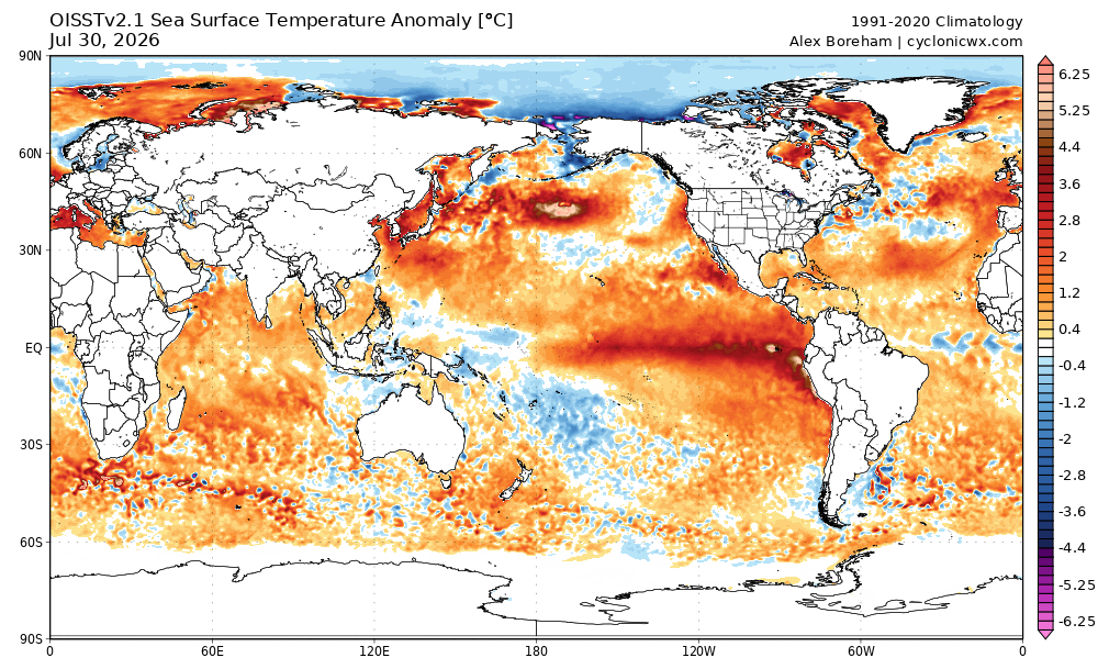
The oceans are on fire globally -

Dewgust 2026: Summer's Last Stand
CoastalWx replied to Prismshine Productions's topic in New England
87 and moist. As it should be. -
2026-2027 Super El Nino
bluewave replied to Stormchaserchuck1's topic in Weather Forecasting and Discussion
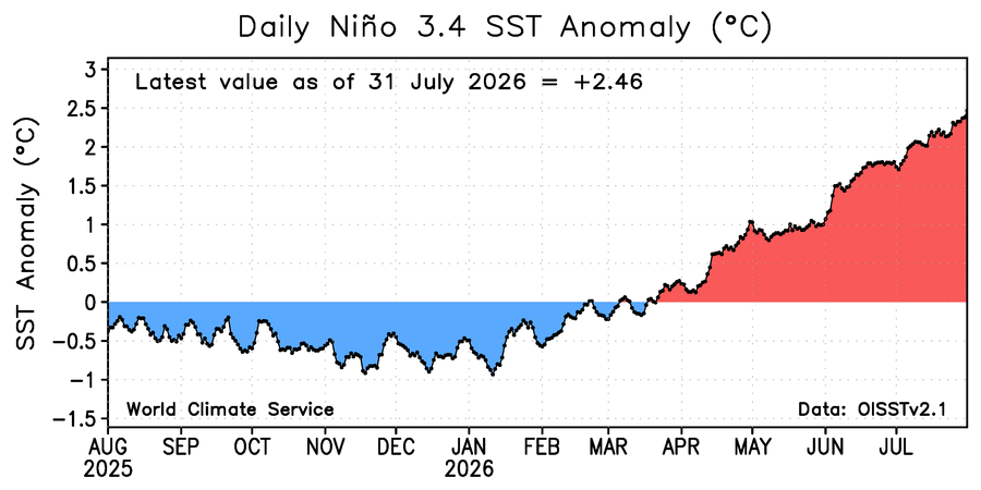
First July 31st ever with a +2.46 Nino 3.4 SST anomaly and a -2.03 PDO.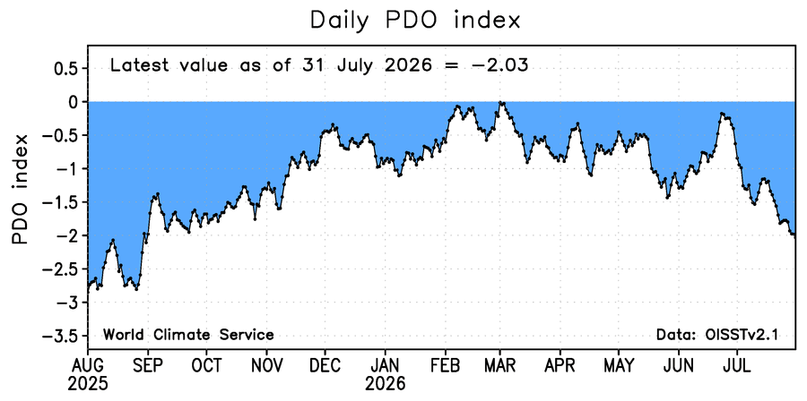
-
Imby/Columbia had 6.89” for July ‘26. Highest since 9.23” in July 2025; but honorable mention goes to May 2026 with 6.29”.
-
^ looks like it’s through just July 1st?
-
Really impressed with the humidity this summer. Even the NW flow patterns aren't really fending off the dews very much. Biked over at Little Bennett yesterday and it had that classic, mid-Atlantic sticky feel in the air. Trails were actually fairly dry, though...which was a little surprising given the recent rain.
-
Appears next week out West will experience the peak intensity of the summer ridge, then it will start to decline. I will go out on a limb and say we have seen the last of the 95 plus heat here.
-
Opinions about this, which shows lowest cumulative YTD burnt area as of July 1st in Americas since at least 2012?@donsutherland1@WolfStock1
-
Up to 88. If not for clouds would probably see some 90s today







.png.34ab37248003ce4357e140cf4da36e79.png)