All Activity
- Past hour
-
Triple digits next week?
-
Rain and thunder woke me up at 2. Gonna be a longgggg day lol
-
Finished just a bit under 2”. Some of the hardest rain we’ve had in a long time. Too bad it was so isolated.
-

Junorch obs and discussion 2026
Damage In Tolland replied to Damage In Tolland's topic in New England
It’s been slow to load for several weeks. I’ve had an iPhone longer than your ponytail is -
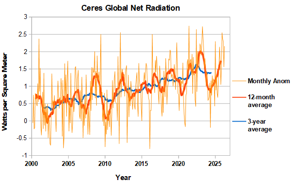
April was another month with very high global net radiation. The running 12-month average is getting closer to the 2023 peak, which occurred in August.
-
Temps in Marquette County this morning ranging from upper 30's inland to upper 40's near shore, 42 here at the house. Probably the last sub-50 morning for a while. Hot and stormy looking good next week.
-
Left in the rain for Mt. Storm, WV to go camping. Received 0.7” on Tuesday imby/Columbia.
-
.20" total here.
-
AFD was making it seem like subsidence would make it dry... which would suck. I want storms with my high heat
-

2026-2027 Super El Nino
snowman19 replied to Stormchaserchuck1's topic in Weather Forecasting and Discussion
In other news, the 90 day SOI is almost -14 and the 30 day SOI is over -18. Massive turnaround since the end of March. Extremely impressive…. -
Bring.It.On
-
.99
-
Yup Up to .99 today and it looks like one more line of showers incoming. I sure didn't expect an inch out of this but I'll take it!
-

Central PA Summer 2026 Discussion/Obs Thread
pawatch replied to Voyager's topic in Upstate New York/Pennsylvania
63 degrees for the low this morning. .35” for rain yesterday. Missing the bulk but getting some rain at least. - Today
-
Not cool. Not cool at all.
-

Central PA Summer 2026 Discussion/Obs Thread
Voyager replied to Voyager's topic in Upstate New York/Pennsylvania
We did well here, too. 0.83" overnight. The "storm" after midnight must have had a pretty good wind component to it, because I registered an 18.6mph gust at 12:35am, which, for my station and it's protected location, is quite impressive. Even on the windiest of days, I rarely record a gust over 15mph. -
@gravityloverI'm you saw the big shift south on the models, looking dry now.
-

Central PA Summer 2026 Discussion/Obs Thread
mahantango#1 replied to Voyager's topic in Upstate New York/Pennsylvania
Good rain last night wasn't expecting that much. .86 rain last night. 1.37 for the week and 2.39 for the month. -
0.02" here, 1.77" for month and 16.70" for year.
-
Central PA Summer 2026 Discussion/Obs Thread
mahantango#1 replied to Voyager's topic in Upstate New York/Pennsylvania
yes, somethings wrong. -
Raining pretty hard here. Up to .4 already.
-
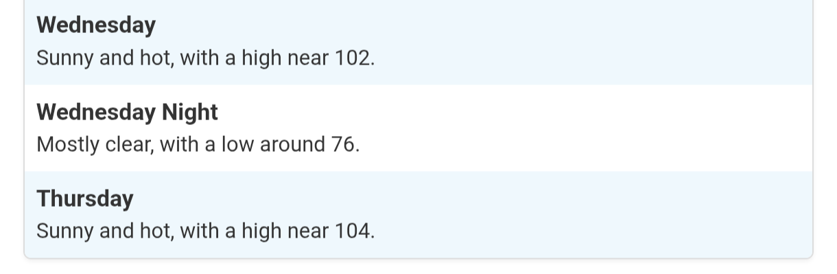
Can't wait Morning ZFP from LWX for DC metro for next week WEDNESDAY...Sunny, hot with highs in the upper 90s. .WEDNESDAY NIGHT...Partly cloudy. Lows in the upper 70s. .THURSDAY...Sunny, hot with highs around 100. Heat index values up to 110.
-
Little pink showing on returns must be some small hail either that or just extremely heavy rain.
-
About to get slammed here in Nanuet.
-
nwnj & orange/rockland counties really getting hammered overnight.