All Activity
- Past hour
-
 Many ASOS I95 PHL to LGA JFK 40 knot gusts now and power outages slowly increasing
 -

November 2025 general discussions and probable topic derailings ...
EastonSN+ replied to Typhoon Tip's topic in New England
Nice snow burst. -
only up to 38F at 1:30pm
-
Hard to see but off to my nw you can see Mitchell . Snow capped! Life in the foothills . All brown here.
-
Central Park recorded 2 accumulating snowfalls in February 2011, after the proclaimed end of winter. 1.6 on February 2 3.2 on February 21 Not bad for a la Nina February if you ask me.
-
 If he is voluntarily outside playing baseball in the snow in freezing / near-freezing weather in November - not even March when the season is around the corner, but when it's officially over in November - that kid is going D1.
 -

November 2025 general discussions and probable topic derailings ...
Hoth replied to Typhoon Tip's topic in New England
First flakes! -
(002).thumb.png.6e3d9d46bca5fe41aab7a74871dd8af8.png)
Central PA Fall Discussions and Obs
ChescoWx replied to ChescoWx's topic in Upstate New York/Pennsylvania
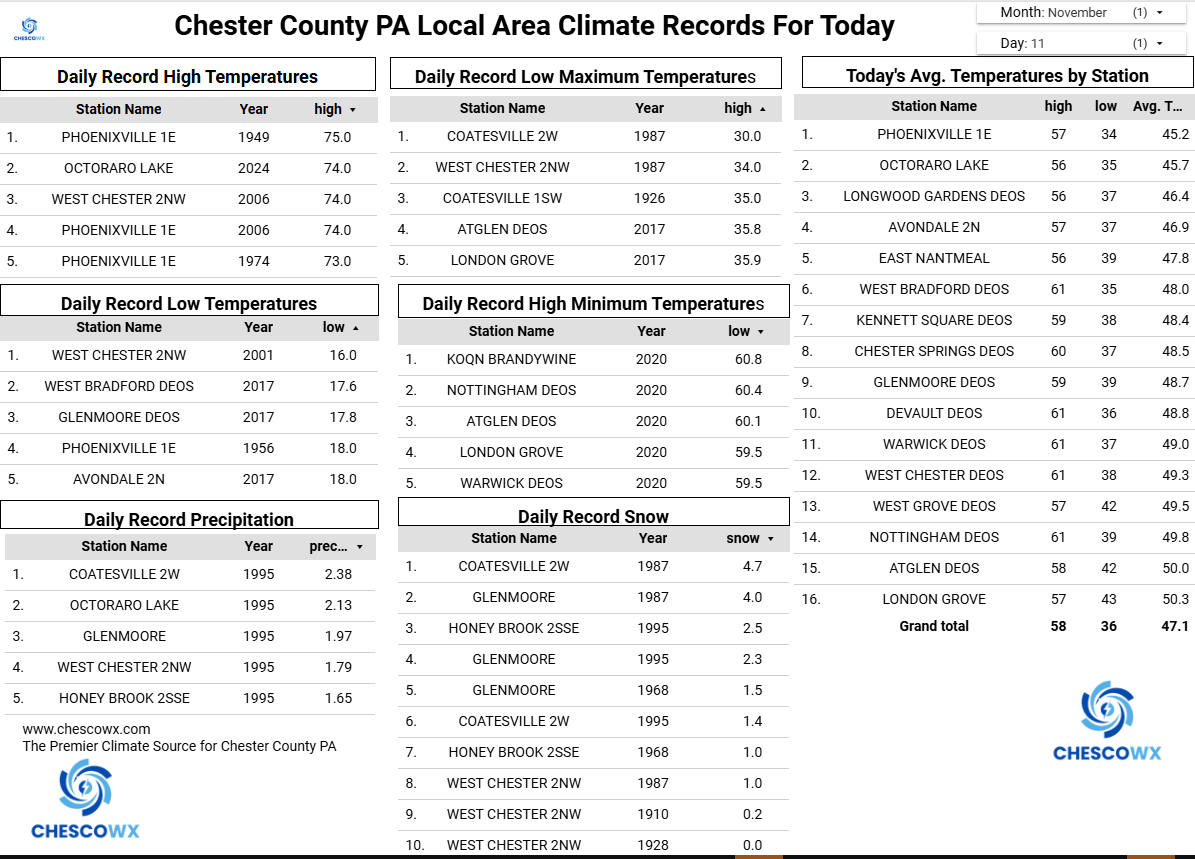
Last night before midnight was our first below freezing temperature here in East Nantmeal since back on April 9th. That ends our freeze free growing season here in NW Chester County at 215 days. In the last 22 years the growing season has ranged from a few as 174 days in 2020 to 233 days in both 2005 and 2024. The earliest first freeze was October 13, 2012 and the latest November 23rd 2015. There has been some occasional snow flurries around the area today with temperatures remaining well below normal for mid-November with highs in the upper 30's. In fact, our high temperatures should stay below normal through the rest of the work week with highs remaining in the 40's in the hills and near 50 degrees in the valleys. We warm up well into the 50's by Sunday with rain chances increasing by then.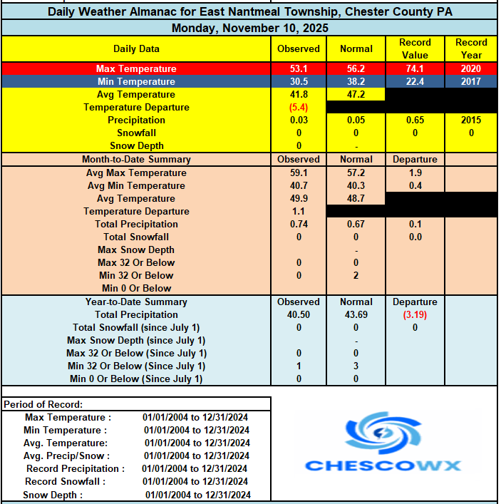

-
E PA/NJ/DE Autumn 2025 Obs/Discussion
ChescoWx replied to PhiEaglesfan712's topic in Philadelphia Region
Last night before midnight was our first below freezing temperature here in East Nantmeal since back on April 9th. That ends our freeze free growing season here in NW Chester County at 215 days. In the last 22 years the growing season has ranged from a few as 174 days in 2020 to 233 days in both 2005 and 2024. The earliest first freeze was October 13, 2012 and the latest November 23rd 2015. There has been some occasional snow flurries around the area today with temperatures remaining well below normal for mid-November with highs in the upper 30's. In fact, our high temperatures should stay below normal through the rest of the work week with highs remaining in the 40's in the hills and near 50 degrees in the valleys. We warm up well into the 50's by Sunday with rain chances increasing by then.
-
Hoping the timing doesn't mess us up! Sent from my SM-S908U using Tapatalk
-
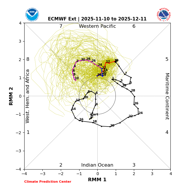
Latest extended EPS extended MJO. Phase 7 to 8 in December would be nice...
-
I find it quite unusual for Davis to report 13 inches of snow when Snowshoe reports only 6 inches since Monday.
-
Note the snow cover in NE NC by the coast as well!
-
Wind chills at TRI dropped to 10F early this morning. I went running at a local state park this morning, and froze my tail off!!! Strava said the wind chills were 24F. Nope - they were 17F!!! That is probably the second coldest run I have done, but felt worse as I was exposed to the wind much more than other running routes. Last night, we had light snow until 10:00PM and likely much longer. This system was a powerhouse. We rarely get NW flow in Kingsport. We had several streamers. If this had fallen at night, we would have easily gotten 2-4" of snow. Just looking at some of the dates being kicked around for November snows...'93 and '14. Those went on to be benchmark winters for cold and snow. Will this winter follow suit? Time will tell.
-
Not sure if it is far enough away from Parkton, @mappy but I will officially be living in Fallston as of Dec. 1. Bad news for @Interstate as I bring my snow shield to Harford County...
-
 Wind is really whipping
 -

12th Annual Mid-Atlantic Snowfall Contest
North Balti Zen replied to RodneyS's topic in Mid Atlantic
BWI: 27.4” DCA: 18.1” IAD: 29.9” RIC: 15” SBY: 8.5” -
BWI: 18.6" DCA: 9.7" IAD: 15.3" RIC: 8.2" Tiebreaker SBY: 8.4"
-

November 2025 general discussions and probable topic derailings ...
Lava Rock replied to Typhoon Tip's topic in New England
yep. I'll usually use the mower deck to push them to the side, then finish it off with leaf blower than rake. Still a pita. And there's other areas not seen around the house. -
November 2025 general discussions and probable topic derailings ...
Lava Rock replied to Typhoon Tip's topic in New England
I'll supply the beer -

November 2025 general discussions and probable topic derailings ...
WinterWolf replied to Typhoon Tip's topic in New England
First flakes…wind blowing better than it did last week lol. -
Made it down to 18 degrees this morning.
-
I had time for a quick ski tour up at Bolton today, so I can pass along a bit of beta with regard to this latest storm and conditions. I’d seen that with the warm front end of this storm, the snow had melted out in the lower elevations of the mountain, so the depths that are there now in the roughly 2,000’-2,500’ range are only from this latest event. Seeing that Jay Peak webcam image above that you posted, I’d say Bolton got hit just a bit better as you surmised – it’s probably similar to what Smugg’s saw. Here’s the elevation-based snow depth profile I observed this morning in the Bolton Valley area: 340’: 4” 500’: 4” 1,000’: 4” 1,200: 4” 1,500’: 4-5” 2,000’: 4-6” 2,500’: 4-6” 2,700’: 5-8” You can see what a weird snow depth profile that is compared to the usual – the snow depth even in the Village at ~2,000’ is basically that same as it is at 340’ at the base of the Bolton Valley Access Road or at our house at ~500’. I only had time to tour up to ~2,700’ this morning, but the snow depths don’t really start to increase until you get above ~2,500’ into the elevations that have pre-existing snowpack, so it looks like the snow accumulations from the front end of this system were pretty consistent over quite a broad range of elevations. In terms of the quality of the turns, today was more like the skiing from the Halloween/November 1st system vs. the much higher quality turns from the November 5th system. This snow was drier than the Halloween/November 1st system, so it skied better in that regard, but going with meadow skipping terrain was definitely the optimal choice for fun turns. The number of folks that I saw out touring today at the resort wasn’t outrageous – the top tier of Bolton’s Village parking area was ~1/3 full, but you could tell the ski touring activity was a bit livelier than the past couple of systems with the way the lower valleys got in some substantial accumulations. I’ll put together a bit more of a report with a few photos as soon as I get a chance.
-
There was no way the 20's were happening with those winds.