All Activity
- Past hour
-
That’s funny coming from the number one AC pusher man on the forum.
-
It will be at the very end of its range, but I'm curious to see what the 12z NAM comes up with Thursday afternoon into the evening
-
Heres your weekly "what is this" post from me... can someone explain ACATT...? Thanks
-
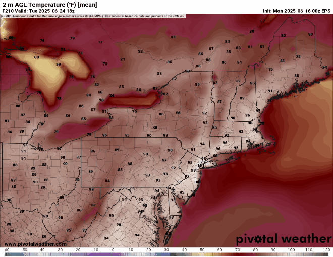
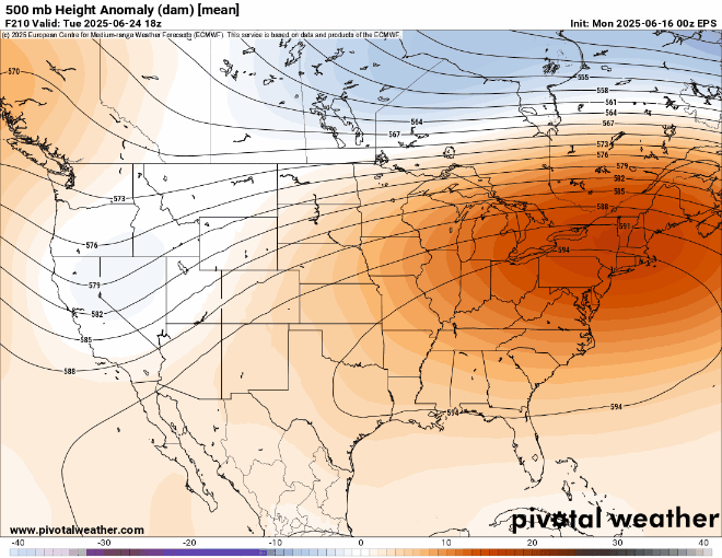
Although the most extreme heat will be North of us next week it will still be the hottest weather yet for the region . Meanwhile, very little rain leading up to the heatwave. .

.gif.3e0e0e999de479f6620b46a35ac5288b.gif)
-
EPS is historically hot this far out. This is no typical heat signal
-
This is a crazy signal this far out. Something historic is brewing
-
Weather folks are putting in the work to let people know the heat is coming.
-
I’m going to ignore all the places that haven’t reported yet, and radar estimates, and declare myself the three-day winner

-
Not sure, but I think Iran is presently receiving unprecedented heat bursts...
-

Central PA Summer 2025
Mount Joy Snowman replied to Voyager's topic in Upstate New York/Pennsylvania
Low of 58 and .15” of rainfall. -
Steady rain again i suppose if it's going to be mid upper 90s soon i'm happy to get as much ground water as possible. I do need to mow though
-
Ok wow I am surprised to see In picked up .59” after midnight. Knew we would get some rain but not that.
-
Very strong La Niña spring pattern as this was the 2nd warmest spring since 1895 behind the 2011-2012 La Niña for the CONUS. Contiguous U.S. Average Temperature March-May March-May 2012 56.17°F 131 March-May 2025 54.09°F 130 March-May 1910 54.07°F 129 March-May 2004 53.98°F 128 March-May 2000 53.90°F 127 March-May 1934 53.73°F 126 March-May 2016 53.66°F 125 March-May 2024 53.63°F 124 March-May 2007 53.50°F 123 March-May 2017 53.49°F 122
-

2025 Short Range Severe Weather Discussion
Stebo replied to Chicago Storm's topic in Lakes/Ohio Valley
Wednesday is interesting, a low ejects out of the plains and strengthens as it moves towards the Straits of Mackinaw overnight into Thursday, with ample instability and a warm front lifting through the state I would expect some severe weather of all modes with a squall line trailing along the cold front. The wind fields are pretty robust as well. -
ACATT will never be able to get past the iron heat dome.
-

2025-2026 ENSO
40/70 Benchmark replied to 40/70 Benchmark's topic in Weather Forecasting and Discussion
Were are the hyper active tropical forecasts?? Col State and the NHC were a hair above average... -
I mean it is summer after all..
-
2013 was not very quiet and below average, it was exactly average. There were 14 named storms and 15 tropical depressions. 14 named storms is average
-
Euro has hundies much of next week on favored spots
-
Gonna be some folks that succumb to the heat in the ACATT crowd. Will become shut ins… invalids, recluse
-
This may be one of the first times that we have seen a 100°+ signal from a 50 member ensemble mean over 200 hrs out.

-
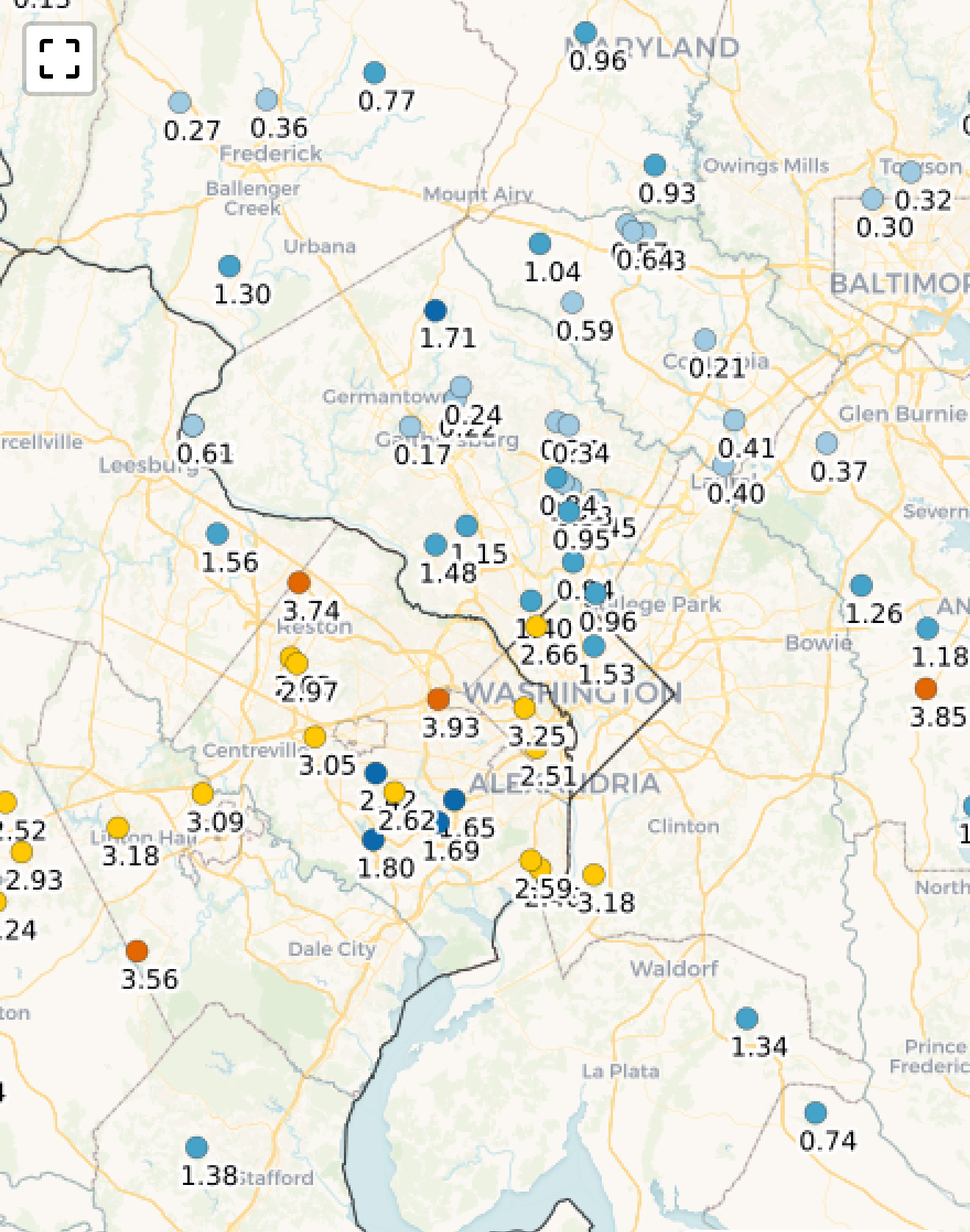
Up to .53" of rain since Saturday evening. Slowly getting there...
-
0z Euro has 104 degrees past Port Jefferson next Tuesday
-
I really wish it would just actually rain. This dreary, cold, drizzly mist just flat out sucks...
-
.10” Saturday morning/afternoon and drizzle yesterday morning up here but was finally able to sit outside yesterday afternoon.
.thumb.png.4150b06c63a21f61052e47a612bf1818.png)