All Activity
- Past hour
-
We shall see if he gets some playing time. That's exactly what he needs. Clearly has more talent than the 2 turds currently playing OG.
-
 Even getting some flurries here currently
 -
Another day of clouds here. The forecast was for mostly sunny. But, so far 90 % of this day has been mostly cloudy. A theme the last 10 months.
-
having to drive back north on sunday, I'm watching this closely, but am honestly more just excited for something to track
-
As I said, we will also want to see GEFS as comparison, not just the EPS
-
Look who keeps giving me weenies
-

November 2025 general discussions and probable topic derailings ...
das replied to Typhoon Tip's topic in New England
Steady snow here in Charlotte, just south of Burlington. There’s about a half an inch on the ground. Temp was 35°F at onset with a dewpoint of 23°F. We have bottomed out at 31° here in the snow as the column saturated. -
I am trying to figure out,is someone really saying it is not? And if so how can they say that?
-
Foothills areas haven't had a big snow in February since 2014.
-
in Fab Febs defense, it actually produced our (my) biggest storm since 2018 last year
-
It's really quite unfortunate that the GFS is not a very good model. The general model consensus is positive for snow and cold after Thanksgiving and that's all I really need.
-
Easy toss.
-
Don't forget magic March.
-
Colder trend on the gfs and cmc for those storms. Lets see if it continues.
-
Canadian is an easy toss!!
-
Same posters doom posters, every winter; just accept it and move on.
-
Meanwhile, the Canadian is much weaker and drier with this system, plus it is dry Sunday-Tuesday while the GFS has two more significant events.
-
Freezing fog in some locations. 30 for the low here
-
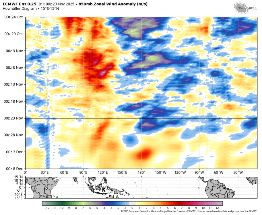
Interesting AO forecast. Lots of spread, and not like the last two years. The strat warming( CW ) not influencing the AO, by a lack of coupling. As mentioned later in this post, in 1958 and 1968 they did couple but several weeks later. Giuseppe Petricca @gmrpetricca 47m Today's zonal GPH chart gives us a good example of uncoupled/limited coupling tropo-strato in the forecast. Strong stratospheric anomalies are present in the 10–50 hPa layer (and above - red rectangle), but below 100-200hPa, the situation is different, with limited vertical coupling (blue rectangle). While the stratosphere maintains a persistent positive anomaly pattern, at least until towards the end of the run, these signals do not propagate downward in a way that would typically influence lower-level circulation (for example, look at the orange/red anomalies back at the start of October, where they covered the entire column). In the troposphere, anomalies remain more variable and horizontally confined, indicating that the two atmospheric levels are acting more or less "on their own".
.thumb.png.1c110d27286b11ebeb987f586764802d.png)
.jpeg.a687b869237c0fc30c11406d0952d55d.jpeg)
- Today
-
On the 12z GFS, we are closer to the cold side of the strong thermal boundary modeled to set up in early December. I expect this boundary to nose southward and affect the north country, but it could potentially push even further south. I'd rather see weaker waves eject northeastward and slowly decay instead of consolidated ULLs pumping the east coast ridge. We could really use some well-timed suppression. The subtle upper level interactions will have huge implications on surface weather over this holiday period and beyond.
-
This is clearly phase 8
-

November 2025 general discussions and probable topic derailings ...
klw replied to Typhoon Tip's topic in New England
light but steady snow has started here. edit: not so steady but still light -

Fall 2025 Medium/Long Range Discussion
sbnwx85 replied to Chicago Storm's topic in Lakes/Ohio Valley
12z GFS continues the trend. A long way to go but it’s a great hit for Iowa and the northern half of Illinois. Starts to lose steam into Michiana but I would take it.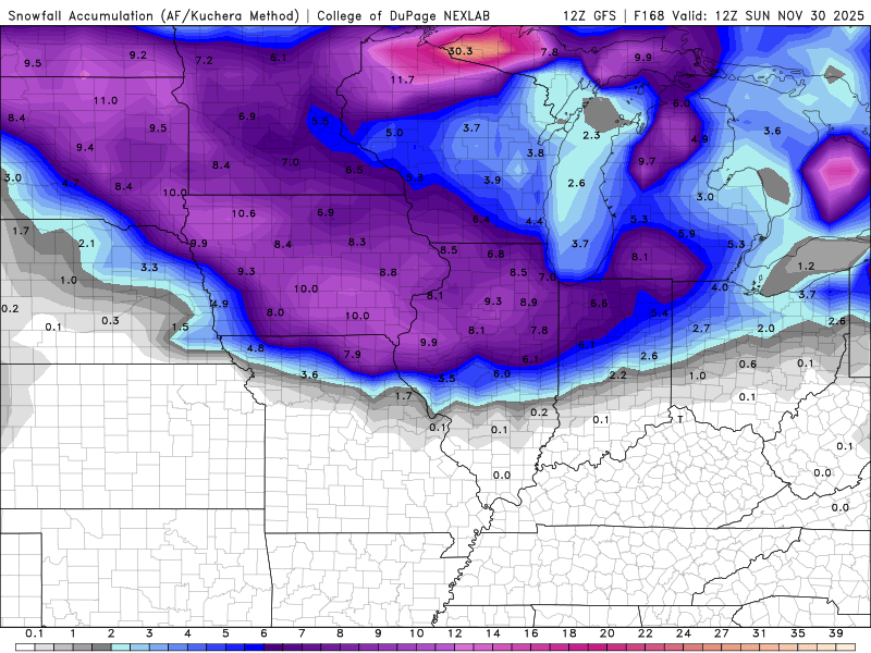
-
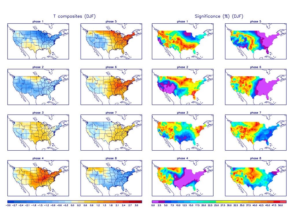
DJF MJO last 15 winters (2010-1 through 2024-5): # of days each phase *7: 286 days from 58 phase 7s or 4.9 days/phase *8: 95 days from 34 phase 8s or 2.8 days/phase 1: 76 days from 24 phase 1s or 3.2 days/phase 2: 96 days from 23 phase 2s or 4.2 days/phase 3: 167 days 4: 173 days 5: 212 days 6: 249 days ——————— Per the above data, the # of phase 8 days for the last 15 winters, combined, has been only 1/3 the # of phase 7 days. This was due to a combo of much fewer 8s than 7s (34 vs 58) and much shorter avg. duration for 8 vs 7 (~3 days vs ~5 days). So, there sometimes is a struggle in going from phase 7 to 8. The # of combined 8-1-2 days has been ~# of phase 7 days, alone! The coldest E US phases have been 8, 1, and 2 while the warmest have been 4-6 (see bottom). The # of phase 8-1-2 days, combined, has only barely been higher than the # of phase 6 days, alone! So, as we look at Dec MJO progs, keep in mind the relative difficulty in getting as many phase 8 days (as well as each of phases 1 and 2, for that matter) as phase 7 days (if any at all). Just because models suggest a 2+ week long phase 7 is very likely doesn’t necessarily mean the durations of each of phases 8, 1, and 2 immediately following will be anywhere near as long, if they even occur. Here are the 10+ day long phase 7s since 2010-1 along with the subsequent phase 8-1-2: - 1/14-30/13: 17 days followed by a combined 15 days in 8-1-2 - 2/19-29/2016: 11 days followed by a combined 10 days in 8-1-2 - 2/2-18/2018: 17 days followed by a combined 10 days in 8-1-2 - 2/7-21/2021: 15 days followed by 0 days in 8-1-2 and instead a combined 11 days in 6-5-6-7 - 12/19/2021-1/9/2022: 22 days followed by only 4 days in phase 8 before going back to 7; phases 7-6-5-4-3 then dominated the next 3.5 weeks. - 1/1-10/2023: 10 days followed by a combined 9 days in 8-1-2 - 2/16-28/2023: 13 days followed by 1 day in phase 6 and then right back to phase 7 for 5 more days…so, 19 days in phase 7 for all practical purposes…followed by a combined 19 days in 8-1-2 - 1/28-2/6/2024: 10 days followed by 2 days in phase 6 and then right back to phase 7 for 10 more days….so, 22 days in phase 7 for all practical purposes…followed by only 1 day in phase 8, which was then followed by a combined 31 days in 7-5-6-7-3-4-5-6 ——————— Analysis of the above: - Much more frequent 10+ day long phase 7 last 5 winters with 5 of them vs only 3 during the previous 10 winters! - The combined 8-1-2 duration was never longer than the prior phase 7 length (using the “for all practical purposes” phase 7 length in two cases). - Of the 8 long duration phase 7s, two (25%) of the following 8-1-2 periods lasted a notable length of 15-19 days and three (38%) lasted a mediocre 9-10 days. However, the other three (38%) were only a minuscule 4 or fewer days long (4, 1, 0) and these were all within the last 5 winters. - So, whereas there’s a decent chance to get a higher end duration of 15-19+ days in 8-1-2 following the upcoming 7, the chance doesn’t appear to be very high and the chance of getting only a very disappointing short period is probably at least about as high. - Thus, recent history tells us that the upcoming 2nd half of Dec MJO is practically un-forecastable as of now with dominance by the often cold 8-1-2 about equally as probable as a feared hardly any 8-1-2. @donsutherland1@bluewave ——————— Daily MJO: https://www.bom.gov.au/clim_data/IDCKGEM000/rmm.74toRealtime.txt
-

November 2025 general discussions and probable topic derailings ...
dendrite replied to Typhoon Tip's topic in New England
Looks like some good bursts in the ALB area.


.thumb.jpg.ad3a2e31d30aff035044689b311a0540.jpg)


.png.19a02b398fe0a2f50f4e0b84e6084932.png)


