All Activity
- Past hour
-
 http://mapletrustrx.com/# canadian drug stores
 -
http://mexisaferx.com/# mexican pharmacy what to buy
-

Augdewst 2026: Summer's Last Stand
vortex95 replied to Prismshine Productions's topic in New England
Thanks. The 1871 event from the reports was likely similar to Iniki in intensity. The thing that made the 1871 event stand out was its angle of approach. Iwa and Iniki all were picked up by a strong trough to the W and accelerated N to the islands. The 1871 event was a just moving within the tropical easterlies. In the cntrl Pacific, the way the mean pattern/flow is in the summer and fall makes conditions rather hostile (wind shear) within about 500 mi E of the islands. So any EPAC system that is intense and tracks W right towards HI weakens significantly to below HU strength by the time it gets to the area. -
Pretty much what they said, right? He'll do well and then have a blow-up game. I'll take it with the starters we have on IL.
-
getting crushed at the house with hail and wind. First hail of the year
-
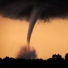
Confirmed tornado SW of Champaign IL.
-
Maple Trust Rx [url=http://mapletrustrx.com/#]Maple Trust Rx[/url] Maple Trust Rx
-
I had a storm "break containment" and move into my neighborhood. Yes, I know I'm using winter cliches in August, but it was exciting.
-
I'm glad you got great LTG. Location, location, location for LTG! And talk about localized. One person gets several very close CGs and ear-splitting thunder, and they are like. "WOW, what storm!" And another a few miles away just gets some mdt booms. Such can change a perception of a storm so easily! The #1 thing I look for always is lots of LTG at my location, esp, close strikes and the really odd acoustics you can get sometimes. Several years ago here, for the first time I had ever witnessed, I actually heard the ZZZTTT!!! when a strike hit about 200 ft away, It was not the typical electric click/pops, more a "frying" noise, probably from arcing from streamers.
-
Sirens going off
-
curl mode activated right as it hit that outflow, very nice
-
 Yeah, this Fall/Winter will be interesting to see if NPH trough develops. It hasn't really happened since 15-16. +SOI correlation was a match the last 2 Summers as well.
 -
http://mexisaferx.com/# pharmacia mexico
-

Augdewst 2026: Summer's Last Stand
Cyclone-68 replied to Prismshine Productions's topic in New England
Iniki was pretty bad for those folks. Still talking about it when I visited a few years ago edit: not questioning what was written above of course -

2026 Mid-Atlantic Severe Storm General Discussion
Eskimo Joe replied to Kmlwx's topic in Mid Atlantic
Two observations: 1.) If there was more DCAPE, the wind reports from Berkley Springs, WV to just north of Annapolis would've been more impressive. Entirely possible that some 70-80 mph gusts would've even been capture on the Maryland mesonet. The Thurmont, Lisbon, and Clarksville sites were hit smack center by that northern cell. 2.) The lightning yesterday was impressive in my neck of the woods. Several positive lightning strikes that were quite brilliant to witness.- 1,880 replies
-
- 1
-

-
- severe
- thunderstorms
- (and 7 more)
-
-
Nice supe in central IL at the moment
-

2026-2027 Record-breaking El Nino
mitchnick replied to Stormchaserchuck1's topic in Weather Forecasting and Discussion
Any chance you can use the same scale on the 500mb maps so as to compare apples to apples? P.s. not to say there will be a difference -
There eggs lay dormant until there is enough rain I believe.
-
Augdewst 2026: Summer's Last Stand
vortex95 replied to Prismshine Productions's topic in New England
Hawaii looks to be impacted by a TS or min HU in about 5 days. The angle of approach is a bit atypical coming in towards the Big Island from the ESE, but it is a strong El Nino, and this results in higher potential for a strong TS/min HU direct hit in Hawaii (Iwa in 1982 is a good example) and the cntrl Pacific is more active overall in El Nino. But the system (93C currently) looks monsoonal and broad, so that should preclude any big intensification. Also, 700-500 RH drops below 60% by 60 hr and below 50% by 72 hr well before it gets to the islands, so despite above avg SSTs, low environmental RH tends to override and will limit things. Of course the MSM will act like it is end of days, as if such an event is unprecedented. I will point out this TC on 8/9/1871. A estimated cat 3 made landfall on the Big Island coming in from the ESE. To get a TC of this strength coming in from the E at that latitude for a landfall is exceptional. No other record of anything like this exitss. Iwa in 1982 and Iniki in 1992 came in from the S https://journals.ametsoc.org/view/journals/bams/99/1/bams-d-16-0333.1.xml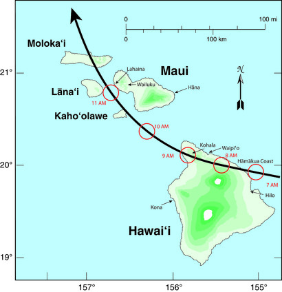
-
Right now, these cells are dying at the Catawba County border. They can't make it out of Caldwell and Alexander. I'm hoping that changes...
-
If you have Netflix, there is an excellent documentary about the Joplin Missouri tornado of May 2011. It was actually quite moving. The destruction was breathtaking.
- Today
-
Augdewst 2026: Summer's Last Stand
vortex95 replied to Prismshine Productions's topic in New England
We have a combo continental/marine climate, so we get just about everything, just less extremes in terms of frequency. Is that so bad? Prevailing westerly flow for continental influence, and the ocean right next to us for marine. 4 very distinct seasons and true variety for all types of wx. @CoastalWxneeds the marine influence for his Weymouth OES! And really, continental climate outside of mountain areas?, 8-14" is considered a monster snowstorm. So be grateful we exceed that for our definition! -
Easy now lol. I like my rain with the power on preferably.
-

Augdewst 2026: Summer's Last Stand
weatherwiz replied to Prismshine Productions's topic in New England
Thank God. IT is unfortunate because its obviously great with CAD scenarios and tends to be better with temperatures along boundaries with extensive clouds and precip but its useless 99% of the time. Oh...should add its also a bit more down to Earth where it will have 93/74 versus the 101/63 the GFS will pull.