All Activity
- Past hour
-
Overnight batch helped me to 0.8 for yesterday and 1.9 since Saturday. Damascus, just 6 miles north, has a CoCoRaHS report of 3.2. I'd like to see the totals for southern FredCo!
-
.62 4 day total Worked yesterday but debating about today. Looks mainly dry after some morning drizzle for me
-
50 in hooksett. Nasty
-
Thursday night looks decent. .25 to .50 inches of rain possible.
-
Another moisture plume showing up off the Jersey shore. Looks headed toward western LI this time. Anyone have a map with all the local rain totals for last night? Curious what the east end saw last night other then the AOS and meso stations
-
Actually a few breaks in the overcast.
-

2024-2025 La Nina
40/70 Benchmark replied to George001's topic in Weather Forecasting and Discussion
This is why winter is warming faster than summer and nights are warming faster than days. The fastest rate of GW is occuring in instances of radiational cooling during the winter. -

2025-2026 ENSO
40/70 Benchmark replied to 40/70 Benchmark's topic in Weather Forecasting and Discussion
-PDO has been steadily weakning...not saying that will defiinitely continue, but I feel like the trend of the PDO is more highly correlated to the weather pattern than the index itself. Maybe someone like @Stormchaserchuck1 can chime in on that, but I feel like the PDO is a bit lagged from the atmosphere. -
55 degrees, picked of .53” of rain overnight. River been coming up slow but steady.basically 2-3’ a day. Looks like the crest will be tomorrow. Well under flood stage.
-
Yes that HI will be miserable for us. It was a few years ago that JFK set their HI record (on back to back days!), both days had a high of 99 and a HI of 117, a true weekend from Hell (complete with power outages!)
-
Wet.
-
Models backing off, was hoping for some damage
-
Only 0.62" total here. That's fine as long as it doesn't go dry for a week. Congrats to those in the moderate-severe drought area. This event at least put a significant dent in it.
-

2024-2025 La Nina
40/70 Benchmark replied to George001's topic in Weather Forecasting and Discussion
Makes sense given CC leads to increased mositure, thus elevating humidity capping heat....its the HI that will be morbid. -
Lost track of total rainfall, since midnight .12"/ low 48F
-
Overnight batch was impressive. Woke me up out of a dead sleep.
-
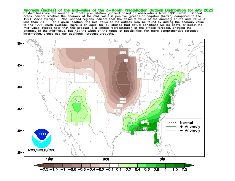
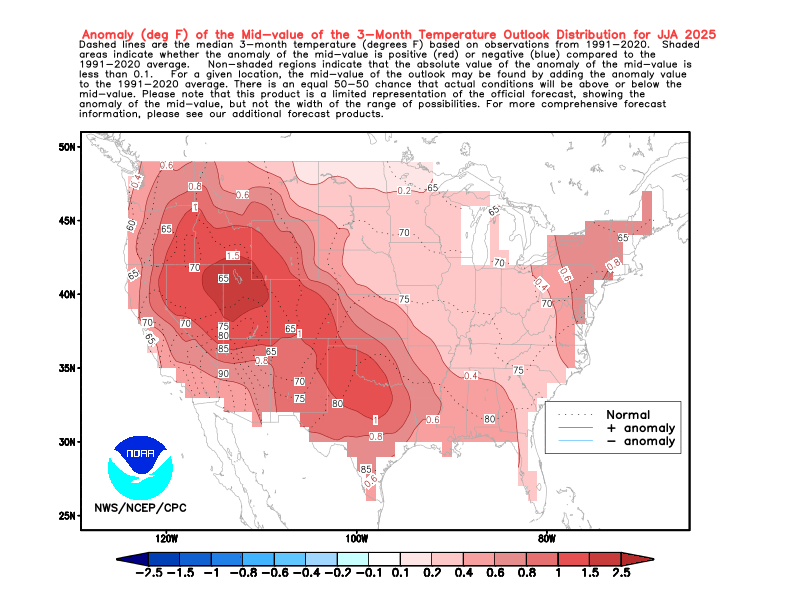
Not sure. But the Euro is usually more accurate with the summer than the winter forecast for us. Probably due to less moving parts in the summer so to speak. The reason it may be wet for us is that there are two ridge centers showing up for the summer forecast. One east of New England and another out West. So perhaps the model is trying to show a weakness in the ridge where there could be some moisture pooling. We’ll see if it has a clue. It’s the same idea as the CPC summer forecast. So probably more high dewpoints and onshore flow like we have been seeing in recent years if correct.
-
-

2024-2025 La Nina
40/70 Benchmark replied to George001's topic in Weather Forecasting and Discussion
Doubt that....humidity is increasing, which while very uncomfortable, caps how warm it can get...HI absolutely may get that high. -
1980 summer here we come :-)
-
The Euro might be wrong about that third one, the NWS has us going into a drier and warmer pattern starting on May 11th (Mothers Day) for an extended period.
-

E PA/NJ/DE Spring 2025 Obs/Discussion
JTA66 replied to PhiEaglesfan712's topic in Philadelphia Region
Picked up .90” early this morning. -
honestly impressed that we've avoided one of these global death ridges for so long, our time will come and we should probably savor the comfort
-
But the X link Tony posted indicated a dry summer for us? Why are these cutoffs becoming much more common, is it because of climate change too? Back in the 80s and 90s our Mays were much warmer and drier and we didn't see cutoffs after April.
-
Drier and Warmer weather for an extended period likely to arrive just in time for Mother's Day (May 11th).


.thumb.png.30196dace342082fab11cd4859a4e2c5.png)