All Activity
- Past hour
-
Just got out of the water. It's freezing. 4mm wetsuit, no boots. Water temp of 54 according to my watch, and that typically reads 1-2 degrees warmer. Sea breeze already in effect, should keep the beach in the low 80s again
-

Occasional Thoughts on Climate Change
donsutherland1 replied to donsutherland1's topic in Climate Change
For the U.S., one hasn't typically seen such heat domes during summers preceding strong/super El Niño events. Such events have been far more common in Europe and Asia. However, during 2015 (Pacific Northwest) and 2023 (July-August in the Southwest/South Central) such domes appeared. Whether these recent events suggest that things are changing in the warming climate (especially more expansive marine heatwaves) remains to be seen. A sample size of two is too small to draw firm conclusions. -
Very high launchpad with temps already 80-85F across the region. 105+ looks certain
-
78/75 @ 7am
-
69/67 here, 45 mins north west of Roanoke. It ain’t bad outside right now in the hills and up the holler haha but I know what’s coming.
-
78/74 this morning as I drink my coffee on my patio. It’s sticky
-
my hygrometer recorded an 80+ dewpoint yesterday with a 122 HI, but I think that's suspect. I'm guessing my real HI yesterday was more like 115 or a bit less. Right now I'm at 75/74.
-
Impressive to see HPN at 80° at 6am. White Plains CLEAR 80 75 84 NW5
-
85 for the low at LGA. .
-
81° low here. Pretty rare for me to have a 80°+ low... Even with some of the big heat last several years it didn't happen.
-
Looks like 80 will be the low temp at DCA https://www.weather.gov/wrh/timeseries?site=kdca
-

Central PA Summer 2026 Discussion/Obs Thread
mahantango#1 replied to Voyager's topic in Upstate New York/Pennsylvania
The grid is expected to break records today. The record was 165.5 Gigawatt in 2006. Forecast to be 166.2 today. Hopefully it can handle it, and it won't go down. -

Central PA Summer 2026 Discussion/Obs Thread
Voyager replied to Voyager's topic in Upstate New York/Pennsylvania
If I can get some good stuff, I will! -

E PA/NJ/DE Summer 2026 Obs/Discussion
Birds~69 replied to PhiEaglesfan712's topic in Philadelphia Region
77F/DP 75F at 6:05am *Philly at 79F...won't go below 80F tonight. - Today
-
 Nice light show last night, but only 0.08” 68.6°
 -
81/76 at 5am at DCA... yuck
-
 At this point there could be a storm with 60dbz overhead , but the sun would be out . We do get ‘d again https://x.com/growingwisdom/status/2071555765949641167?s=46&t=dhcbvkjmRcyBVQtDxJ3lRg
 -
Central PA Summer 2026 Discussion/Obs Thread
mahantango#1 replied to Voyager's topic in Upstate New York/Pennsylvania
US National Weather Service State College PA Favorites ·pnosodrSet8cm27lmct20la13592u9481367m0ltc6ti288til8gg72lgag4 · Thursday July 2nd, 2026 @ 5:20 AM EDT Adams, Dauphin, Lancaster, Lebanon, and York Counties: Extreme Heat Warning extended through 8 PM July 4th Persistent heat/humidity will support a conditional threat of spotty severe storms capable of producing damaging winds on July 3rd & July 4th -
Central PA Summer 2026 Discussion/Obs Thread
mahantango#1 replied to Voyager's topic in Upstate New York/Pennsylvania
I's basically a once in a lifetime experience that this is happening. Hopefully you'll share them video and photos -
Central PA Summer 2026 Discussion/Obs Thread
Voyager replied to Voyager's topic in Upstate New York/Pennsylvania
Oh, I most certainly will! I took a vacation day because the Union Pacific Big Boy is coming through Tamaqua today. I live so close to the tracks that it's practically going through my backyard. I could sit on my back patio and watch it go by, but it's doing a 15 minute photo stop at the train station, so I'll be walking down there to see it, and hopefully get some good pics and video. -
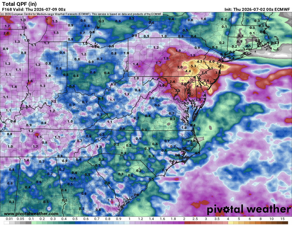
Despite the MRGL/SLGHT risk SPC has for the region Fri, it still looks to me too warm aloft and capped for any significant storms most of the region. Still +12 C at 700 most of the day. The ridging aloft starts to break down by late aftn, but models show very limited storm coverage. Isolated storms at best. Best chance the PA border and SW VA/parts of WV. Looks good for considerable tstm activity Sat-Mon. GFS and ECMWF quite wet for the region in the next week.

- 883 replies
-
- 3
-

-
- severe
- thunderstorms
- (and 7 more)
-

Central PA Summer 2026 Discussion/Obs Thread
pawatch replied to Voyager's topic in Upstate New York/Pennsylvania
5:00 am 74 dgrees. Stay hydrated today. Voyager enjoy your day Might try and squeeze a grass cut in this morning. Clover gone wild -
 It sounded good west of me towards UCOnn/IJD and then fell apart approaching 395. Low of 72F here so far, S FL like.
 -
max HI 113 high temp 96
-
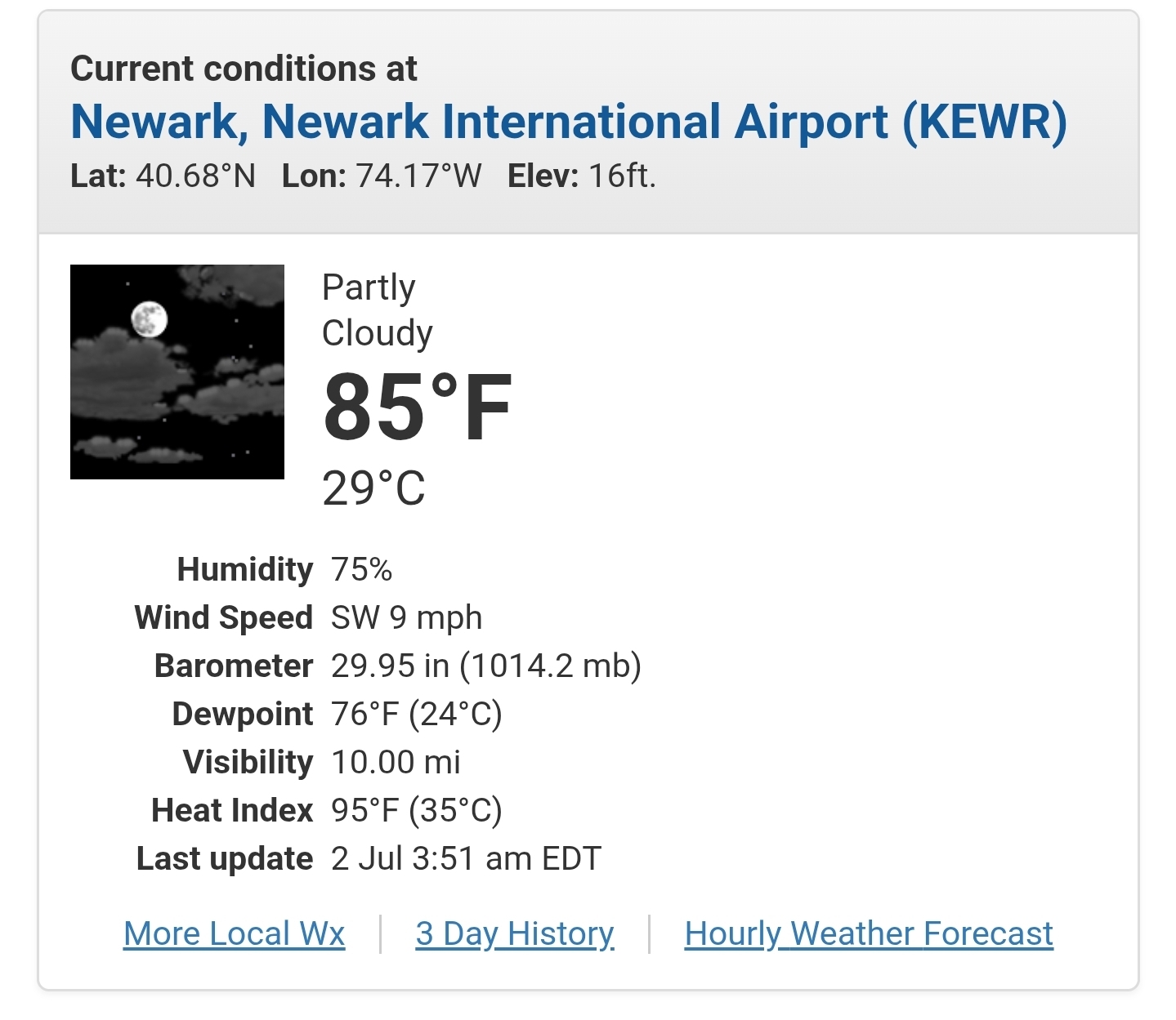
 What a night for Newark with a low of 85 and a heat index of 95.
.thumb.png.366dedcd9dfe5b96071bfddc12a3e5d8.png)
.thumb.jpeg.f5c6ba9d911ec96b3b124f8606aee58e.jpeg)


.png.12e53ee33f3d588d0ace9acea757d800.png)