All Activity
- Past hour
-

Jan 30th-February 1st 2026 Arctic Blast/ULL Snow OBS Thread.
Daniel Boone replied to John1122's topic in Tennessee Valley
Most times they go with what Model Data is printing out like many do anymore. It caused them to miss by a large margin in much of the Area. Sometimes you gotta use logic and incorporate Human Input. Not downing them or the Other's as it's just the way things have become nowadays, sadly. Until Model's get (if it's really completely possible) more micro precise , if you will, without the Forecasters skilled Input it will remain the same. -
It will certainly change. I really wish we could get a good 2-3 year period of ENSO neutral conditions. I think that would go along way of stabilizing things for a bit
-
(002).thumb.png.6e3d9d46bca5fe41aab7a74871dd8af8.png)
E PA/NJ/DE Winter 2025-26 Obs/Discussion
ChescoWx replied to LVblizzard's topic in Philadelphia Region
Same here quite a bit of ice sliding off roof into yard!
-
Obviously…nothing in MET science ever is. But the bigger point is this is just another one of the many theories that have their time in the sun, and then we realize there’s so much more to it.
-
 Agree. No matter how thick the ice, it's always cracking, which allows water to seep up into the snow layer when that snow is sufficiently heavy. Usually, the slush layer is only 1-2" but I've seen it change the entire snow layer when ice thickness is modest and snowfall is heavy. Then the re-freeze leaves the upper part of ice as less-rigid gray.
 -
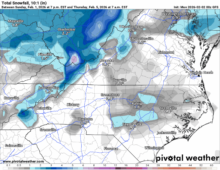
12z CMC is a hit along the border of North Carolina and Va
-
I guess? A couple years from now that will change too. So we just hang tight for the time being.
-
I don't disagree with where this is going. Everything has to go perfectly. I think up along the VA border may do okay with this event, especially if trends towards a more amped system continue
-
You’re thinking about it too binary though. It affects everywhere. But you keep saying “if location X gets a snowstorm, then it must not be happening there.” And if someone says it’s happening here, they mean zero snow. Maybe for one region it decreases the chances by 10%… for another area they have already low chances of snow so it decreases chances by a percentage point or two. But there’s always a percentage chance the storms happen. It’s like a sliding scale and changing the probabilities. It’s not a binary yes or no.
-
Hopefully we can get one without any screw zone ala President's Day 1 - 1979. Still one of my all time favorites with temps in the teens, howling wind, and 14" in the upstate IMBY. It did warm up rather quickly the following week but still took several days to melt.
-
Temp has sky rocketed to 26F here. I was mildly surprised this morning seeing the ground wasn't snow covered in Punxsutawney.
-
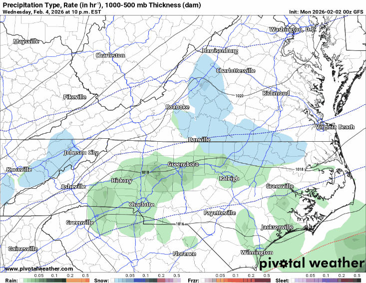
12z CMC really likes the mid week system
-
12z GFS headed in the right direction once again!
-
If it isn't 6+ I don't want it anyway but none the less too many boundary layer issues and cold chasing with this one. The GFS has been horrendous with every event.
-
7.3 - our cove has a sheet of ice on the water. Wild to see considering just how scorching the water was this summer.
-
I mean, is there any setup in todays climate that would even support getting those S tier record lows? PVD got to -13 in 1976 but even the 70s were significantly colder than todays climate. I remember the afternoon of January 21, 2019 only got up to 5F in PVD, but even that is super rare. I think what is more surprising to me though is the fact that even with a warming climate we havent had any heat waves that rival the all-timers like 1911 and 1975. It seems like the 70s had more extremes with both cold and heat for some reason. We just don't get that anymore.
-
Crazy how quick things change in weather. Went from looking like a great period to cold and dry, mild week with some rain chances mixed. Thankfully we still have half of the month even after the warmup
-
Great find.
-
Bone dry hope we can ger dustings Wed morning and sat morning
-
We have snow flurries as well.
-
Well technically it doesn't only affect the northeast coast of the U.S. it has an effect everywhere but the effects (or the results) or just the by product. For us a byproduct is just shitty luck, for areas to our west and south the byproduct is increased potential.
-
Yeah I'll check this out more, Phys.org is pretty great. And thanks for the last paragraph, that is precisely what I was trying to illustrate but could not put into coherent wording. I think having a sound fundamental background in this understanding can go along way in medium range forecasting. If there is one thing I would really love to study further and understand it's wave spacing and factors which influence wave spacing...and then how forecast models handle wave spacing.
-

2025-2026 ENSO
donsutherland1 replied to 40/70 Benchmark's topic in Weather Forecasting and Discussion
IMO, the Wbell anomalies are too cold. If one moves up one category (e.g., -5 to -7 becomes -3 to -5), one will probably be closer to the final values. Having said that, the Northeast will very likely finish below normal. With the expected readings through February 14th, one would need a top 5-10 warm finish just to bring the anomalies to normal. So far, none of the guidance (even the CFSv2) is showing sustained warmth of that magnitude. -
Although all of Wake was a screw zone this time for the most park lol.
-
After my 35th straight day of 45° and drizzle in May