All Activity
- Past hour
-
Surprised at this little storm but we take. Before this we were at 2.02" since 7/1.
-
The whole area along RT 2 from you to N Adams is super dry.
-
 Temperatures will likely top out in the middle and upper 80s across the region. Saturday will likely be somewhat cooler before it turns briefly warmer on Sunday. Noticeably cooler air will likely overspread the region early next week. High temperatures will likely reach the upper 70s and lower 80s during the first half of next week. The extended range guidance increasingly suggests that the closing week of August could feature below normal temperatures. Precipitation could be near normal. The synoptic pattern should limit direct tropical cyclone threats for the foreseeable future. Impacts from elevated tides, surf, and rip currents would be the most likely effects produced by Erin as it tracks well offshore between the U.S. East Coast and Bermuda. The ENSO Region 1+2 anomaly was +0.8°C and the Region 3.4 anomaly was -0.3°C for the week centered around August 6. For the past six weeks, the ENSO Region 1+2 anomaly has averaged +0.50°C and the ENSO Region 3.4 anomaly has averaged -0.15°C. Neutral ENSO conditions will likely continue into early autumn. The SOI was +0.18 today. The preliminary Arctic Oscillation (AO) was -0.342 today. Based on sensitivity analysis applied to the latest guidance, there is an implied 58% probability that New York City will have a cooler than normal August (1991-2020 normal). August will likely finish with a mean temperature near 75.6° (0.5° below normal). Supplemental Information: The projected mean would be 0.4° above the 1981-2010 normal monthly value.
 -
Congrats Hampton again
-
Can you imagine back in the day when it not raining was due to witchcraft? No wonder stuff got so crazy. Sent from my SM-G970U1 using Tapatalk
-
Wouldn't be surprised if we see something pop up around the Carver area, watching the clouds from my office window and it just grew massively in the last half hour or so.
-
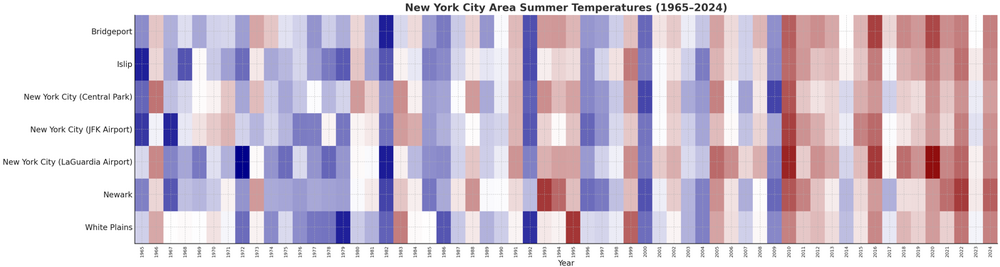
This outcome is consistent with the warming summers that the region has been experiencing. Warming is measured by summer mean temperature. I constructed a chart for seven regional sites for the last 60 years and pegged the shading to the median value for each site.
-
Steined here so far today. Maybe something pops but it doesn’t look good.
-
1.60" and getting ready to get hammered again. And there's the flash flood warning. This is probably the 5th flooding event I've had since July first.
-
So far August has produced . . . dust. GYX has us with 60% PoP Sunday. 2 days ago that same 60% was forecast for today. Reminds me of an old comment about wx signs - in a drought, all signs fail.
-
Got sorta skipped but about 0.25”
-
Tstorms to my west, I can hear them but they'll probably dissipate.
-
Maybe you should read his posts a little closer before spitting out knee-jerk reactions? It's either that or you are really bad at geography. Calling WV a "western" state that has "nothing to do with the area" is a complete head-scratcher. Harper's Ferry is 40 miles from the DC line
-
0.08 here in 21057 for the day.
-

2025-2026 ENSO
Stormchaserchuck1 replied to 40/70 Benchmark's topic in Weather Forecasting and Discussion
Yeah, two -PDO/Weak Nina seasons in a row with +PNA? That's what I'm thinking.. the PDO actually scores so high on long range predictability, and I found that when it didn't work one season, it worked the next season at 1.24x the average. Anyway, energy traders are hedging on a warmer Winter bet over the last few weeks. Natural Gas December contract dropping from $4.80 to $3.70 over the past few weeks.. despite -PDO rebounding a bit.. that's a bet on more +NAO conditions this Winter. - Today
-
Complete opposite here. I've probably had close to 2" and steadily pouring. It's been a swamp here all summer. I'd love a dry spell. Looks like chances of rain for the next week. That means nothing there and storms everyday here lol
-
 We have some light westerlies in that most recent batch of data from recon which is meaningful, but still, not terribly organized.
 -
Hardly any rain here…becoming very reminiscent of last summer and probably ‘23 as well.
-
Me yesterday.
-
Getting hit hard again by a cluster of thunderstorms. The area of heavy rain is generally moving SE.
-
radar estimates of 1-2" about 1-2 miles east of me. can't make it up
-
Oh, it’s pretty clear that history will in time reveal the whole tariff thing, regardless of whatever it is/was espoused as being, was actually just a grift - a grand bilking scheme.
-
Headed to the coast next weekend. It sure seems Erin nudges closer to the coast with each GFS and Euro run. Haven't seen any forecasters predicting landfall but some have said we could experience some outter bands.
-
 high 90 so far...day 5 of my 6th heatwave churns on
 -
Nice rolling thunder out there... Looks like I am getting ready to get by that line in Baltimore County

.thumb.png.4150b06c63a21f61052e47a612bf1818.png)


