All Activity
- Past hour
-

“Cory’s in NYC! Let’s HECS!” Feb. 22-24 Disco
Henry's Weather replied to TheSnowman's topic in New England
Shots fired -
They’ve all been for the past 3+ years and the fails keep piling up way faster than the blown 10-20” calls.
-
This is a good follow on social media -> UC Berkeley Central Sierra Snow Lab 2/19/26 8:30 am Update - the atmosphere is clearly showing off: 1-day : 25.6" 2-day : 54.9" 4-day : 92.5" And just in case you thought we were done… another 8–16" expected TODAY. At this point, the snowpack is basically building an extension onto the lab. Send snacks. Or a shovel. Or both.
-
WINTER WEATHER ADVISORY IN EFFECT FROM 10 AM FRIDAY TO 7 AM EST SATURDAY... * WHAT...Mixed precipitation expected. Total snow and sleet accumulations of a coating to 3 inches and ice accumulations up to around two tenths of an inch. * WHERE...Northern Connecticut, northwest Rhode Island, and much of Massachusetts along and south of the Massachusetts Turnpike. * WHEN...From 10 AM Friday to 7 AM EST Saturday.
-

Feb 22nd/23rd "There's no way..." Storm Thread
ravensrule replied to Maestrobjwa's topic in Mid Atlantic
@EastCoast NPZ vehemently disagrees. -

“Cory’s in NYC! Let’s HECS!” Feb. 22-24 Disco
weatherwiz replied to TheSnowman's topic in New England
Also, after that stretch we had in January to the first part of this month, these temperatures aren't bad lol. Actually feels nice walking outside. I am sure in another month highs of 30's and lower 40's will get old but until then we enjoy -
Its all about timing
-

“Cory’s in NYC! Let’s HECS!” Feb. 22-24 Disco
CoastalWx replied to TheSnowman's topic in New England
Will be gone before or close to it -
I am going to use as neutral of language as possible - there is a systematic, and gleeful dismantling of the atmospheric science infrastructure ongoing at the Federal level. Operationally, the National Weather Service lost many positions at key field offices. A short-lived Federal agency that shall remain nameless listed the building that houses the SPC/NSSL for sale. The National Science Foundation has been cut to ribbons The National Center for Atmospheric Research's very existence is now being threatened. These changes are likely to stay in place for at least the next two years. Even if there was a dramatic shift in Federal policy starting in 2028, you cannot easily rebuild back to what we had prior to 2024 overnight. These cuts are worse than physical buildings, or personnel positions - the loss of institutional trust is enormous and is cumulative. Meanwhile, our international competitors will continue to lap the country. We are simply headed in the wrong direction and fast.
-
“Cory’s in NYC! Let’s HECS!” Feb. 22-24 Disco
CoastalWx replied to TheSnowman's topic in New England
Need to put him and MoreGarbage onto the glass plane like in Superman and send them to space. -
Stunning day here, good enough for a cigar by the firepit. 44.8° and about as blue a sky you can get. Warnings up, and a decent shot at 6" around these parts.
-

“Cory’s in NYC! Let’s HECS!” Feb. 22-24 Disco
Damage In Tolland replied to TheSnowman's topic in New England
This pack will last well into Morch -

“Cory’s in NYC! Let’s HECS!” Feb. 22-24 Disco
Snowcrazed71 replied to TheSnowman's topic in New England
Here's where I'm having trouble with understanding these model runs. Why is there such a difference between two major models? Okay, one's American and one's European, but technology should be pretty equal in today's world, wouldn't you think? It's super frustrating. I'm sure I'm not the only one who feels this way -

“Cory’s in NYC! Let’s HECS!” Feb. 22-24 Disco
VivaManchVegas replied to TheSnowman's topic in New England
This was in this mornings write up from Gray. There is still hope for some of you massacrists. A trough begins digging into the Mid-Atlantic Sunday sparking cyclogenesis off the coast of the Carolinas. Meanwhile, high pressure builds over the northeast making for a mostly dry day with seasonable high temperatures. The aforementioned low begins moving northeast up the coast with many ensemble solutions suggesting high pressure keeps it mostly at sea. However, there are some notable recent trends in the ensemble guidance. The wave of interest that ultimately kick starts this is just coming into range of the RAOB network and really doesn`t enter the Pacific Northwest until later today. That being said with what limited recon data the models have been able to incorporate, they have trended the ridge in the western CONUS more westerly. This would ultimately allow the low to end up closer to the coast and result in a greater chance for a more impactful snowfall for the Northeast. While the majority of ensemble members are clustered well to the south and east of the benchmark, there are still more than a few members nearby. It would be unwise to write this one off just yet until it can be sampled further. -
3-5" of concrete...
-
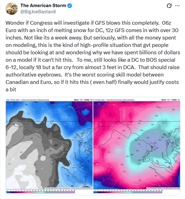
Here's his tweet on the storm: I don't disagree with his sentiments concerning the GFS. It remains perplexing that when it came to the last major upgrade of the GFS, NCEP did not adopt the top-flight 4dVAR initialization scheme that is used by the ECMWF, GGEM, and UKMET. Weaker initialization puts the model at a disadvantage from the start. Occasionally, the model scores, but far more often than not, other models provide better solutions. Finally, a significant or major hit has been a low probability, high-impact scenario. Unfortunately, as the lead time has diminished the overall probability of such an outcome has not increased. If anything, it has decreased. There's still uncertainty, but time is running out.
-

Feb 22nd/23rd "There's no way..." Storm Thread
SnowenOutThere replied to Maestrobjwa's topic in Mid Atlantic
Will point out for those interested in seeing snow Sunday we got two pretty good options. Firstly, there’ll be a good upslope on the WV ridges. Secondly, most models agree Shenandoah will be able to squeeze out some accumulations even if the coastal misses. -

-
Honestly the Euro isn't that far off, it's 6-12 hours too late on phasing with that southern energy that the GFS does. Everything else looks great, we just need that southern vort ejecting out of the Rockies to continue to tick slower. It's really all phase/no phase related.
-
Looks cold going right into the first of March, Far cry from being over.
-
“Cory’s in NYC! Let’s HECS!” Feb. 22-24 Disco
weatherwiz replied to TheSnowman's topic in New England
We have a long ways to go before any sort of sustained major warmup. Heck, even looks like we're a long ways off from anything even a bit above climo. May as well just keep things active with potential events. Probably looking at another year where we go from 40's to 80's in a span of three days -
Concentric deathbands
-
Congrats Chesapeake Bay. Should help mitigate the sewage spill from the potomac downstream
-

Feb 22nd/23rd "There's no way..." Storm Thread
rjvanals replied to Maestrobjwa's topic in Mid Atlantic
One thing to look at today is if there's a severe weather outbreak over the southern Il and IN and spreading east which the Euro is predicting vs the GFS which is predicting less of a outbreak that dies out quickly as it moves east -
He’s a joke. It still works for him to get the clicks and subscriptions?