All Activity
- Past hour
-
Just begging for an arctic outbreak to get the lake-effect machine going. Would do numbers.
-
I don't either Ji, ur a f*ckin delight!!
-
It was these two for me. The first was amazing. I absolutely loved the sustained snopamine. Snow cover weenie through and through. The second event was impactful in terms of coastal flooding in the bay.
-

Occasional Thoughts on Climate Change
WolfStock1 replied to donsutherland1's topic in Climate Change
This. I don't think the "sky is falling" people realize just how foolish they look when anyone who doesn't toe the sky-is-falling line must be a denier; and as a result how counter-productive it is to their cause. -
Mine was the January snowstorm that dropped 10+" for my hood, but a very close second was the absolutely immaculate August in these parts. It's been since the summer of 2014 where we had August temperatures like that. It was a welcomed sight after a brutal 37 day stretch from June 23rd to July 30th with the heat and humidity, including 120+ heat indices during the late June heat wave across parts of the lowlands.
-
Lmaooo
-
93-94 was tops, we had like 10 storms here and cold.
-
For a single event, I guess I’d go with the January snow since it was only the 2nd time in 6 years that we had 6”+ on the ground. And it stuck around forever unlike the Feb snow which was gone in two days. Really though, the story was the complete lack of precip from about mid-July forward.
-
That's my birthday! Jan 32, 2026!
-
We're gonna get a massive biblical historic blizzard on January 32nd!!
-

January 2026 regional war/obs/disco thread
dendrite replied to Baroclinic Zone's topic in New England
24.6° -SN -

January 2026 Medium/Long Range Discussion
Stormchaserchuck1 replied to snowfan's topic in Mid Atlantic
I'd put higher probability on it. Or the time afterward, Jan 20-30 period. It's not much of a risk that the N. Pacific ridge currently extending into Alaska and the Arctic circle on models will trend into -PNA, donsoutherland has done research that 45-day -PNA periods in the winter, like the one we just had flip to +PNA 80% of the time afterwards. Also, there is a kelvin wave starting to move warm water across the ENSO-subsurface, and I have found that correlates to more +pna conditions as it happens. Greater probability is that the N. pacific ridge ends up north with a low even undercutting it, vs the opposite, imo. -

January 2026 regional war/obs/disco thread
Damage In Tolland replied to Baroclinic Zone's topic in New England
H to the 3rd is really bad on temps . Any kind of ll cold or CAD it fails terribly -
January 2026 regional war/obs/disco thread
Damage In Tolland replied to Baroclinic Zone's topic in New England
But it got the no snow idea right yesterday all of SNE. Everything else had 1-2 -
With all this ravens and Harbaugh talk, I'm only got one thing to say... ONLY 40 DAYS TILL SPRING TRAINING!!!!
-
Sad that it's come down to making appointments for secs 2 weeks in advance.
-
We may have no choice, but to accept a snowstorm during that timeframe.
-

January 2026 regional war/obs/disco thread
WinterWolf replied to Baroclinic Zone's topic in New England
HRRR has been abysmal period for the most part…glad it’s being replaced. -
I hadn't seen your follow up post when you mentioned those states outside the northeast. Tis odd to call the scale what they did then.
-
Sad east coast society?
- Today
-

January 2026 regional war/obs/disco thread
CoastalWx replied to Baroclinic Zone's topic in New England
Man the HRRR was so bad today. Nam ftw. -

January 2026 regional war/obs/disco thread
Go Kart Mozart replied to Baroclinic Zone's topic in New England
Pretty much all models show the MJO ready to take a nice trip towards the left side. GFS has highest amplitude. -
The 18z AI EPS. Some big dogs in there. Two separate storms. Windows are 14-15th and the 20th.
-

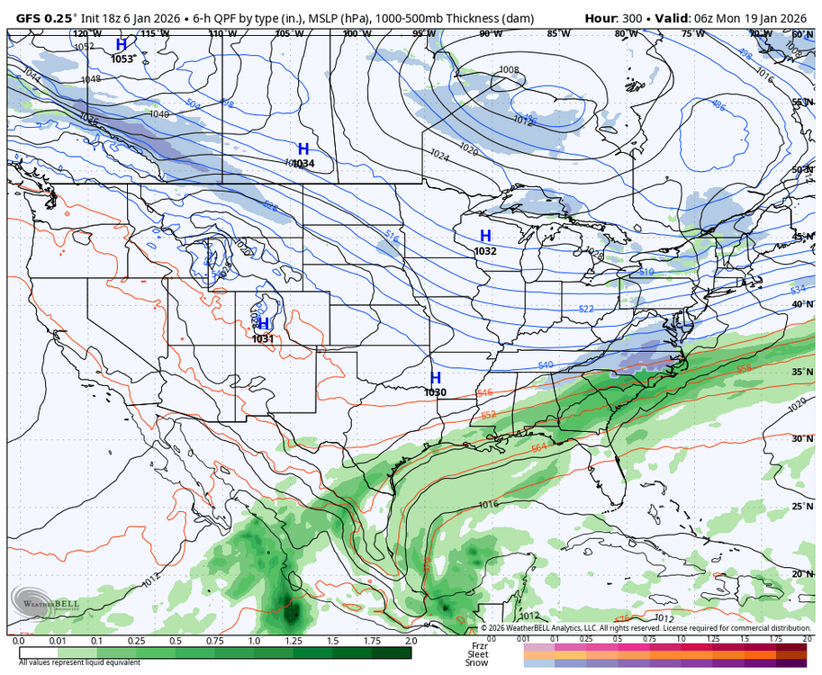
Central PA Winter 25/26 Discussion and Obs
Blizzard of 93 replied to MAG5035's topic in Upstate New York/Pennsylvania
18z GFS shows a couple of opportunities between the 15th & 19th. The first chance is light this run, but could have been more if the pieces phased better. The second chance misses south this run, but again the potential is there.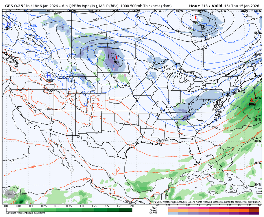
-
So we are all set then Jan 20-21 secs


