All Activity
- Past hour
-
 It’s all relative my friend morning low was 20. You know that felt amazing on your morning run.
 -
Low of 33 this morning. Snow is melting slowly.
-
To me they're the same thing...a SWFE is a Miller B which does not transfer and re-develop til N of 40 or 41N while a Miller B IMO is one that transfers and re-develops from like 39 or more 38N south. Also the transfer N of 40N is always sloppier and longer, because you have land mass extending more E over SNE than you do over DE/VA where the ocean is further west. Some of my friends and I used to call them Swmiller Bs at times....here's an example of one from 2/1993, you can see how it attempts to transfer over SNE but its messy and even most of SNE went to rain here. https://www.meteo.psu.edu/ewall/NARR/1993/us0222.php Blizzard of 1996 is a true Miller B, the transfer happens way more south. https://www.meteo.psu.edu/ewall/NARR/1996/us0107.php
-
Eh, it has a tiny dusting but it’s been going the wrong direction the last few runs in how much precip makes it over the Apps
-

Friday February 6 FROPA / WINDEX small event
8611Blizz replied to HoarfrostHubb's topic in New England
The only downside to this map is it might take 12 hours or more to fall.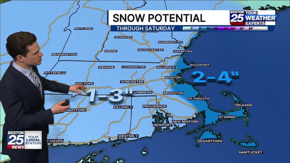
-

February 2026 Medium/ Long Range Discussion: Buckle Up!
WxUSAF replied to Weather Will's topic in Mid Atlantic
He’s been vigilant for PD3 for 23 years now -
Get this within the NAM’s wheelhouse at hour 3, and this place will explode.
-
-

2025-2026 ENSO
40/70 Benchmark replied to 40/70 Benchmark's topic in Weather Forecasting and Discussion
Apparently the CPC agrees, considering they are now using RONI as the official measure of ENSO intensity. https://www.cpc.ncep.noaa.gov/products/analysis_monitoring/enso/roni/#latest-data -
I'm skeptical with amount of sunshine peeking thru and current temps for much in the way of snow----limited window for precip changeover. I have jumped to 44 here near Winston Salem.
-
Wouldn't it be a bit unusual to see a 970s low on the DE coast in a SWFE?
-

Central PA Winter 25/26 Discussion and Obs
Voyager replied to MAG5035's topic in Upstate New York/Pennsylvania
I had a nice "mild" overnight, but it seems like instead of the rapid after sunrise warm up that I get many mornings, we're going to slow roll to our high for today. -
This event UNEQUIVOCALLY lived up to the thread title for once!
-
Never forget.
-
Yup. Sounds like the ONI will continue being maintained but the RONI will be the go to now.
-
If we do get another round of winter the MJO forecast points to around the 21st or after so we shall see
-

WxUSAF's weak ass frontal passage thing.
EastCoast NPZ replied to dailylurker's topic in Mid Atlantic
Well, that would be the second-largest event of the winter here. What's the snow depth out there? Heading out there this weekend to do some sledding at Blackwater. -

February 2026 Medium/ Long Range Discussion: Buckle Up!
stormtracker replied to Weather Will's topic in Mid Atlantic
Warms the heart. Positive vibes simmering -
 Thaw today? With highs in 20’s
 -

February 2026 Medium/ Long Range Discussion: Buckle Up!
IronTy replied to Weather Will's topic in Mid Atlantic
JB is on storm watch for our PD3. -
Got a whopping 1.2" here
-
Is we back? February discussion thread
40/70 Benchmark replied to mahk_webstah's topic in New England
This must be in response to CPC finally replacing the archaic and outdated ONI, which I have been virtually ignoring in my intensity assessments for a few years now. -
Friday February 6 FROPA / WINDEX small event
Damage In Tolland replied to HoarfrostHubb's topic in New England
It’s gon snow! -
I hope this system misses us. Our infrastructure cannot handle another beat down like last night's.
-
Being pretty sure or confident on any long term weather pattern is an oxymoron. Knowing how complex these things are, statements like these serve no purpose and are not productive.


