All Activity
- Past hour
-

February 2026 Medium/ Long Range Discussion: 150K Salary Needed to Post
CAPE replied to Weather Will's topic in Mid Atlantic
I should have posted that in the other thread because most here only care about the surface- specifically snow maps. It all happens upstairs. -
 She is a tool. It’s 10 Feb.
 -
Low of 26 at 5:57am, high of 71 at 4:21pm. The north-side shadow sleet remains..for now. I'm really hoping for a good wash of the roads tomorrow, but chances of that are diminishing.
-
That's because there is a lack of precip now. It's not from lack of cold air up there.
-
You don’t maybe. Don’t agree on that point. We had a sleet bomb in the teens. Never imagined that would happen. For many of us average temps suck ass for snow. That is my considered opinion.
-
February 2026 Medium/ Long Range Discussion: 150K Salary Needed to Post
CAPE replied to Weather Will's topic in Mid Atlantic
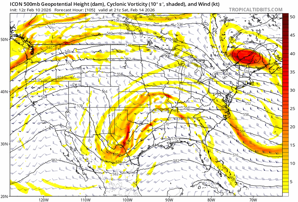
Disparity. Which one is closer to reality? Time will tell. A strong jet streak upstream amplifies the trough on the Euro. Not so much on the GFS. -

E PA/NJ/DE Winter 2025-26 Obs/Discussion
LVblizzard replied to LVblizzard's topic in Philadelphia Region
If this is it for prolonged cold and lots of snow chances, I’m glad we had a front loaded winter for once. I’m fine with an early spring with the kind of winter we had in December and January. -

Feb 10-11 Mid Week Minor Event - Ride the hot hand?
Roger Smith replied to HoarfrostHubb's topic in New England
The low pulled in some quite mild air that will now be forced up and over as the support vanishes. It was up to near 50F in w PA and parts of w NY. I think 2 to 4 inches may be fairly widespread except in s.w. CT where 1 inch would be my call. Local 4 to 6 bands in VT, NH and ME still seem possible. -
47 for a high imby. Shaded and wooded areas look untouched.
-

Feb 10-11 Mid Week Minor Event - Ride the hot hand?
Dalfy replied to HoarfrostHubb's topic in New England
Seems like we're battling quite a bit of virga in Leb, humidity is at 50%. Flurries to very light snow despite ~25 dbz. -
Dont forget your favorite storm, Feb 2021. However, neither of those two you listed were historic (18"+) for S/SW CT, like you guys get consistently with Jan 22, Jan 15, Feb 15 etc with those crazy 18-30+ numbers. Both those storms may have sucked in E MA but they werent historic level storms either around here.
-

Feb 10-11 Mid Week Minor Event - Ride the hot hand?
Damage In Tolland replied to HoarfrostHubb's topic in New England
Is timing on the stuff like 9-12? -

Feb 10-11 Mid Week Minor Event - Ride the hot hand?
ORH_wxman replied to HoarfrostHubb's topic in New England
Rap increased QPF a lot on 21z run compared to previous several runs. Mostly due to the convective stuff performing better. -
I have 6" log outer walls- R value isnt the best but not as relevant because of the high thermal mass(heat storing capability).
-
 Well, I wouldn't take what some deterministic model says at face value going farther out in time. I mean heck...if anyone saw the 12Z GFS earlier, it had cold coming back in the last part of its run and even had a decent snow event around the 24th. Not that it matters really that far out. So whatever.
 -

Feb 10-11 Mid Week Minor Event - Ride the hot hand?
DavisStraight replied to HoarfrostHubb's topic in New England
I think most of Maine does well, maybe 3-4 where I am and the coast north of Portland up to 8 inches. -

Winter Storm Threat *Technical* Discussion. No Op Run PBP or Snow maps
osfan24 replied to CAPE's topic in Mid Atlantic
Kinda weird since he would just regurgitate anything the Euro spits out. -

Feb 10-11 Mid Week Minor Event - Ride the hot hand?
tavwtby replied to HoarfrostHubb's topic in New England
radar backfilling in NY, maybe can catch some of that later, they cancelled basketball tonight because of this, amazing... -
I only lived there one year ‘95-96, but this was my experience there. Not sure I saw the sun for 2-3 months.
-

Feb 10-11 Mid Week Minor Event - Ride the hot hand?
RUNNAWAYICEBERG replied to HoarfrostHubb's topic in New England
Yea. C-1” for SWCT. -
 Lol. No forecaster knows that they can even predict 3 days out let alone rest of winter
 -
Feb 10-11 Mid Week Minor Event - Ride the hot hand?
tavwtby replied to HoarfrostHubb's topic in New England
yeah dews in single digits all day, sfc temp marginal as well... I can probably count the flakes that have fallen so far -
 Low 40s as far as the eye can see.
 -
 Good thing we dont really need true Arctic air in February to get snow.
 -
 Talk about a bad model