All Activity
- Past hour
-
Flags of caution. Posts of certainty i.e.: ERIN is a landfall miss. There are no certainties, probabilities most assuredly certainly. With each update the models for the most part have been remarkably consistent. By no means am I stating a forecasted landfall. Consider the track has been South and West with a delay in intensification. The newer Hurricane Models show this. ECMWF, GFS ensembles wagons WEST. I enjoy tracking these suckers. A great diversion from life reality. Anybody ever fight with an Insurance Companies reluctance to pay on a claim? How does one get them to pay for work already performed? I ask because last Wed. A 100ft, 6ft wide trunked live oak fell and punctured 4 holes. Guilty until proven innocent. Invoice from Tree crew hired gave me a total of $8500.00 (reasonable considering the damage) The point contact stated "way over priced." The house was sold, well under contract and only 4hrs away from inspection. MOTHERTUCKERS!
-
Temp down to 77 at home with 0.12" of rain. It's better than nothing.
-
Hippy knew it was coming.
-
Most here agree
-
 86, partly cloud. Was hoping for no humidity... Oh well.
 -

Invest 98L - 20/20 - Recon enroute Thursday afternoon
GaWx replied to BarryStantonGBP's topic in Tropical Headquarters
MJO climo to keep in mind regarding Invest 98L: Hurricanes since 1975 in Jul-Sep that hit S or C coast of TX in MJO phase 2: -Hanna of 2020 -Harvey of 2017 -Claudette of 2003 -Bret of 1999 All S or C coast of TX H landfalls Jul-Sep since 1975 by MJO phase: -1: Allen 1980 -2: Hanna, Harvey, Claudette, Bret -3: Beryl 2024, Dolly 2008 -4-8: none So, of the 7 Hs to landfall on S or C TX Jul-Sep since 1975, 4 (57%) hit during phase 2 and 6 (86%) hit during either phase 2 or 3! The MJO is in phase 2 today and is progged to likely be in phase 2 tomorrow though phase 3 is a slight possibility. Just some climo for thought. -
 crazy without any sun
 -
Still squarely a threat to Newfoundland.
-
And they appear to be slow moving
-
Yeah I was at Hydes Field in Baldwin...you could see the rain and lightning... but nothing at the field except for a canceled soccer practice.
-
about 1.5" last night from an overhead cell developing. very close lightning and shook me out of the bed.
-
Hope they all miss the USA.....the fish can afford them but most Americans can't
-
Give me a pattern changing 1" - 3" event the week before Christmas. Then a nice 6" - 10" cold powder event on Christmas Day afternoon that sticks around for a week.
-
Yep
-

2025-2026 ENSO
michsnowfreak replied to 40/70 Benchmark's topic in Weather Forecasting and Discussion
Are you thinking a more front loaded winter? Or rather....a winter where December is one of the bigger hitters rather than Jan/Feb? -

Tropical Storm Erin - NOW AT 50 KTS!
WxWatcher007 replied to BarryStantonGBP's topic in Tropical Headquarters
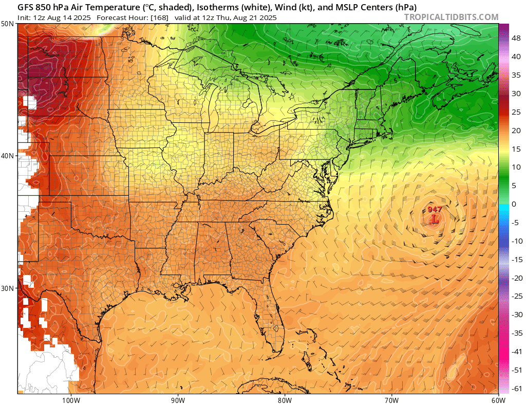
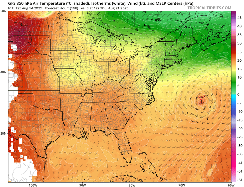
Just want to continue to highlight that even if Erin isn't a direct threat to the US, it is potentially a threat to Atlantic Canada, specifically Newfoundland, with models showing misses, close approaches, and more direct impacts in various model runs. -
Absolute whiff for the most part in Fallston last night. Almost hilarious how close it was to raining but refused to.
-
We have been leaning more on RONI in recent years reflecting the much warmer global oceanic state. Plus record WPAC warm pool north of the tropics has lead to the record low -PDO enhancing the La Niña background state. So the 2020s have been serving up a new type of La Niña background where it has been more defined by the WPAC warm pool than how cool the Nino 3.4 SSTs have been. It’s also interesting that the weaker RONI winters have been warmer in the multiyear La Ninas groups since 2010. 22-23 featured only a -0.83 weaker RONI and it was the warmest winter of the 3 year group. 16-17 had a weaker positive-0.73 RONI and it was the warmest winter of that two year event. Same for the 11-12 weaker RONI of -0.82 coming in as a warmer winter than 10-11 was. Multiyear La Ninas and DJF RONI https://www.cpc.ncep.noaa.gov/data/indices/RONI.ascii.txt 25-26…….? 24-25….-1.12 22-23…..-0.83 21-22……-1.21 20-21…...-1.17 17-18……..-1.10 16-17……..-0.73 11-12…..-0.82 10-11……-1.42
-
At least for my part of the state, July seems to be our only Tstorm month going back several years.
-
Summer winding down. Large flock of Canadian geese went overhead this morning.
-

2025 Atlantic Hurricane Season
BarryStantonGBP replied to BarryStantonGBP's topic in Tropical Headquarters
-

2025-2026 ENSO
KakashiHatake2000 replied to 40/70 Benchmark's topic in Weather Forecasting and Discussion
https://www.facebook.com/share/p/1ZRAvb2Cut/? climate prediction center on the new enso probabilities -
Look at that ridge pumping on the N/NE flow around Erin… If anything we need to wait for it to get out of the way to allow the return flow back in.
-
@canderson we find ourselves in a familiar spot currently Sent from my SM-G970U1 using Tapatalk


.thumb.png.4150b06c63a21f61052e47a612bf1818.png)