All Activity
- Past hour
-
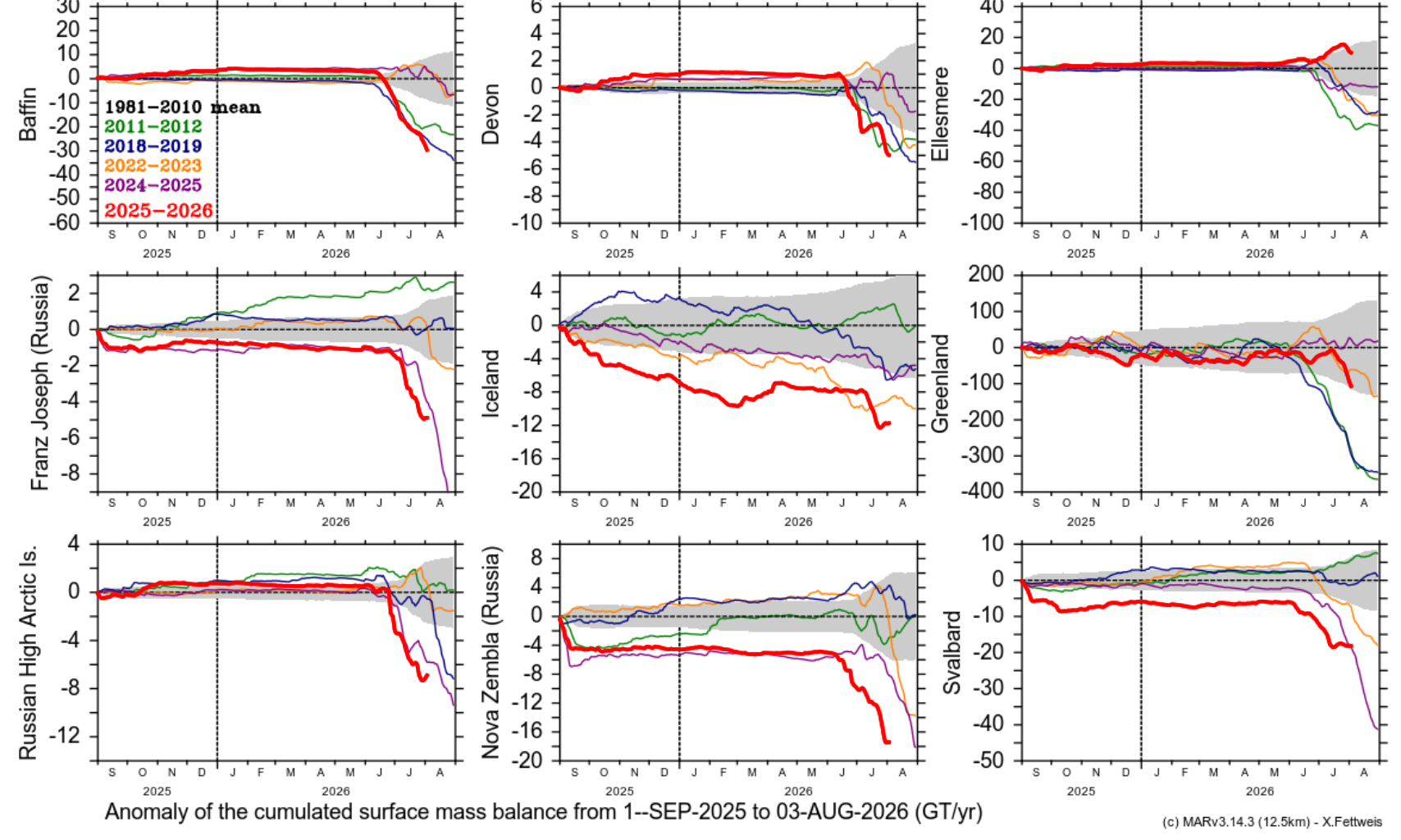
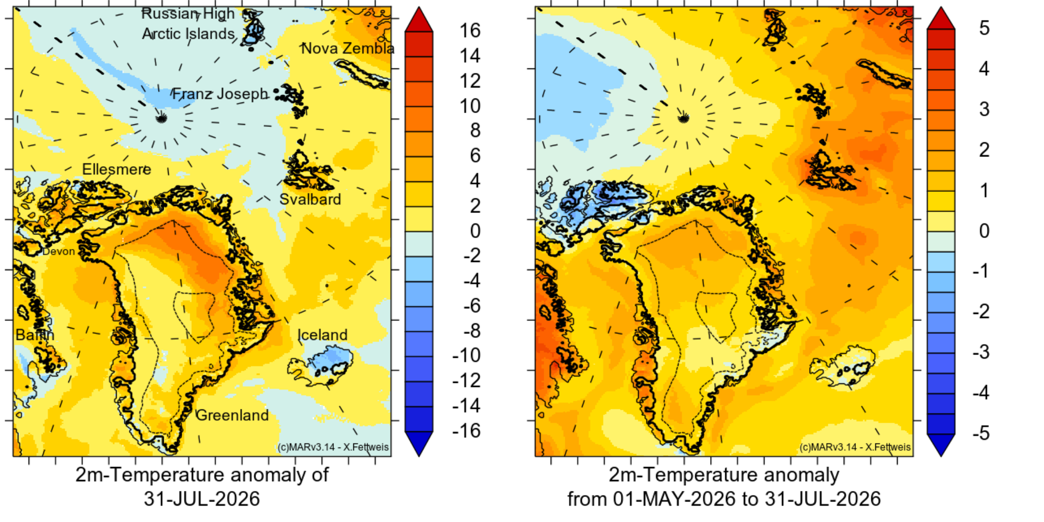
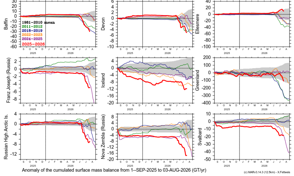
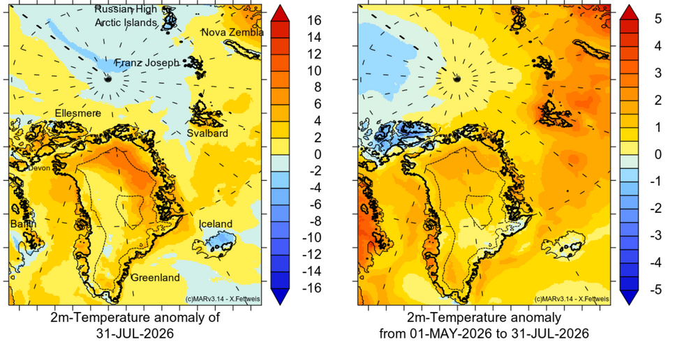
Most of the Arctic Ice caps are having a record or near record melt year. The exceptions are Greenland which has above average losses and Ellsmere Island the which is having below average losses. The loss distribution is consistent with the average temperature map since May 1. The Atlantic side of the arctic has been warm, while the Pacific side has been cool. Other than Ellesmere, the arctic ice caps are on the Atlantic side. https://www.climato.uliege.be/cms/c_5855702/fr/climato-arctic
-

2026-2027 Super El Nino
EasternLI replied to Stormchaserchuck1's topic in Weather Forecasting and Discussion
That is the PDO battle royale in a nutshell. As a -PDO plus +ENSO can yield a weaker Aleutian low than you would otherwise expect to see. Yet, PDO variability and transitions has links to the strength of the Aleutian low too. So it's fascinating watching a +enso of this caliber coming up against the deeply entrenched -PDO state. Since Aleutian low strength has ties to +enso strength also. Does one or the other win out? Or is it more of a blend between the two? I lean towards a record el nino taking an upper hand at some point. I feel like this event has some potential to flip us out of that long term -PDO state too or at least begin to. Who knows, but it's really interesting to watch. -

2026-2027 Super El Nino
bluewave replied to Stormchaserchuck1's topic in Weather Forecasting and Discussion
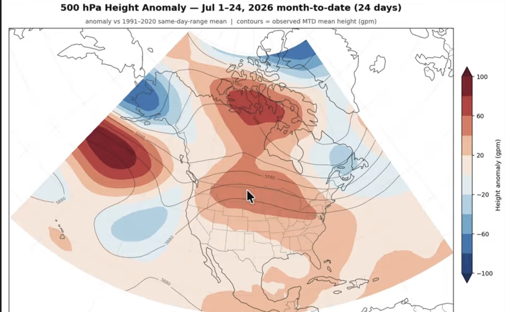
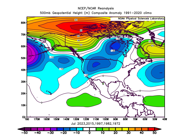
2026 is near the warmest July on record in my first post using 1991-2020 climate normals at +2.5 since that is the base period Brian used. The departure would be even higher if an older base period was used. My 2nd post uses 1971-2000 climo and even that cooler one shows that 1987 wasn’t a warm summer for the CONUs even during the 1980s. Notice the warmest summer of that decade was 1988 which came in the summer after the El Niño and not before. So this El Niño is getting off to a much warmer start than usual. It’s El Ninoish since it matches most of the pattern for an El Niño summer from the Pacific across to the Atlantic. Every spot isn’t going to be a 100% match. But most of the area from the Pacific to the Atlantic is a reasonable 500 mb match whatever the base period is used for an El Niño summer. A hallmark of a developing very strong El Niño pattern during the summer is higher 500mb heights further north and lower heights underneath from the Pacific to the Atlantic. This summer the pattern is reversed which lead to all the record warmth across the CONUS. The record ridge north of Hawaii this month is the reason that the PDO had the steep drop in July. This is not the 500 mb pattern that we have typically had during any El Niños which were on their way to super status. So this event is in a league of its own in numerous ways.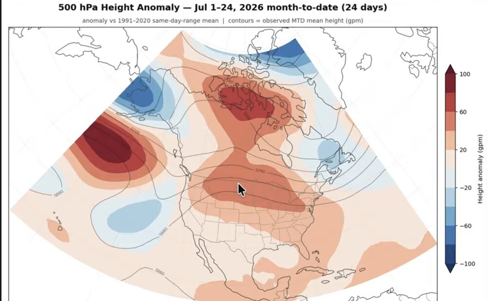
-
This is easily the greenest my front lawn has been in years. Its usually burnt out by the end of july and i can usually go weeks without mowing.
-
 sildenafil online: MedMenNews - Order Viagra 50 mg online
 -
Cheap Viagra 100mg: Viagra without a doctor prescription Canada - buy viagra here
-
Waxing
-
That trade is kind of weird. Why would Minnesota win Dean Kremer?
-

Chester County PA - Analytical Battle of Actual vs. Altered Climate Data
chubbs replied to ChescoWx's topic in Climate Change
Nope. Your station selection and AI's method are both faulty. The key period for evaluating the Coatesville post-war moves is 1945-1950, the period immediately after the war when the moves occurred. I didn't include Sadsbury, Kennett Square, and the other Chesco stations you listed, because they didn't operate in that period. After reading the AI analysis more closely, I see that AI used regression analysis to make its determination. As I said above, that is a poor choice because the station moves are focused in time not spread out over a long period of time. AI based its conclusion largely on regression results from Devault and Morgantown both of which didn't start operating until 1951. AI is drawing a conclusion from two stations that don't provide any information on the Coatesville post-war moves; because, they weren't operating at the time. A clear indication of a faulty analysis approach. With 2 of the 3 Chesco stations, Caotesville and Phoenixville, both experiencing spurious cooling between 1945 and 1950, It is important to include non-Chesco stations in the analysis. That's why my analysis included 10 non-Chesco stations. The non-Chesco stations and West Chester agreed completely with West Chester in identifying the common weather signal between 1945 and 1955. Having the common weather signal makes identification of the Coatesville and Phoenixville moves easy; and, with plenty of stations is highly significant statistically. A faulty analysis does not disprove a good one. To disprove my analysis, you need show that the significant difference between the move and non-move stations in the 1945-55 period changes when more data is added. Good luck with that, the P value is 0.0001. -
buy Viagra over the counter [url=http://medmennews.com/#]Med Men News[/url] viagra without prescription
- Today
-
Day 4-8 Convective Outlook NWS Storm Prediction Center Norman OK 0317 AM CDT Sat Aug 01 2026 Valid 041200Z - 091200Z ...DISCUSSION... ...Day 4/Tuesday... A broader-scale trough is forecast over central Canada into the north-central U.S. with a series of subtle disturbances moving through the base of that feature. At the surface, a front is expected to move through the upper Great Lakes with the western extension of the boundary settling slowly south through the central High Plains. A severe weather threat may materialize from the mid MO Valley into the central High Plains along the front and in the post-frontal upslope, where an overlap of moderate instability and stronger vertical shear is expected to reside. Elsewhere, a more widespread area of moderate instability developing across southern AZ could support a locally greater risk of severe storms. The extent of the severe weather threat in both areas is currently too uncertain to delineate an area. ...Day 5/Wednesday... The broad, cyclonic flow regime will continue over the north-central CONUS with a belt of slightly enhanced mid-level winds extending from the northern Rockies through the northern and central Plains into the Great Lakes. At the surface, the previously mentioned front will continue through the Great Lakes with the boundary extending southwest through the mid MS Valley into the central or southern High Plains. Similar to Day 4/Tuesday, some severe weather appears possible along the boundary over the lower MO into mid MS Valleys, as well as within the post-frontal upslope across the central High Plains. The subtle nature of the forcing for ascent leads to uncertainty in severe storm coverage, so no area will be included. ...Days 6-8/Thursday through Saturday... The 00Z ensemble means are in reasonably good agreement in depicting the continuation of an upper high over the southwestern U.S. with lower-amplitude troughing over the Great Lakes into the Northeast. At the surface, there is considerable model spread in the location of relevant boundaries that might focus severe storms. That being said, much of the available AI guidance suggests an increasing severe weather threat in the Mid-Atlantic during this time frame. Model trends will continue to be monitored for the possible inclusion of an area in subsequent outlooks. ..Mead.. 08/01/2026
-
http://medmennews.com/# Med Men News generic sildenafil
-
 I wanted Mt. Washington baked out for Mid-Am in October but looks like they got too much rain.
 -
 Synthetic Aperture Radar (SAR) products that give very detailed surface wind profiles for TCs. Click on the storm you want and then "profile plots" for the max winds in each quadrant and RMW text output, among other things. https://www.star.nesdis.noaa.gov/socd/mecb/sar/sarwinds_tropical.php
 -
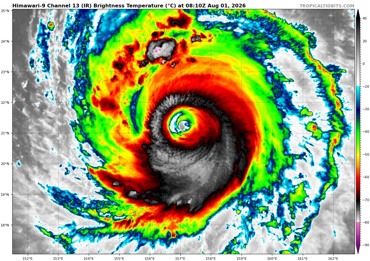
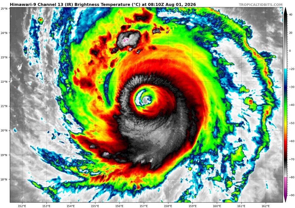
Looks like Dolphin is ready to form a huge eye. Several hours ago, I got about 20 nm for a eye diameter. Based on what I see on EIR now, the new larger eye is going be be close to 60 nm!
-
Yes, higher OHC means what can form and intensify has better potential. However, one thing I have learned is that there is lot more to it, and it is surprising/counterintuitive at times. This underscores what I say a lot, you can't think of the global system in a 1-2-3 linear manner. Human nature is conditioned though for this, as in correlation = causation in a very basic sense! Look at this BAMS paper concerning EPAC and WPAC TC intensification rates. You'd think the WPAC would be "better" for everything concerning TCs b/c it is the most active region on the globe, but that is not true. noaa_54129_DS1.pdf
-
Viagra online price or Buy generic 100mg Viagra online generic sildenafil http://www.1491.com.tw/phpinfo.php?a[]= Cheap Sildenafil 100mg and http://orbita-3.ru/forum/index.php?PAGE_NAME=profile_view&UID=153967 Order Viagra 50 mg online [url=https://images.google.fm/url?sa=t&url=https://medmennews.com]Cheap generic Viagra online[/url] Viagra without a doctor prescription Canada and [url=https://kigalilife.co.rw/author/rcdzrftlsf/]sildenafil over the counter[/url] Viagra tablet online
-
Viagra online price: cheap viagra - generic sildenafil
-
It was an outlier and now lost it.
-

2026-2027 Super El Nino
snowman19 replied to Stormchaserchuck1's topic in Weather Forecasting and Discussion
+12C subsurface anomalies are coming And the WWBs just keep pushing that 30C isotherm further and further east of the dateline. Great forecast by the EURO months ago showing the record far east warm pool -
Cheap generic Viagra online [url=http://medmennews.com/#]Med Men News[/url] sildenafil over the counter
-
http://medmennews.com/# MedMenNews Viagra without a doctor prescription Canada
-
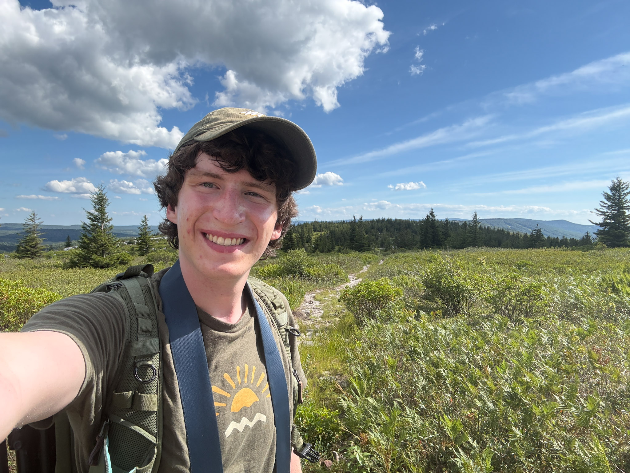
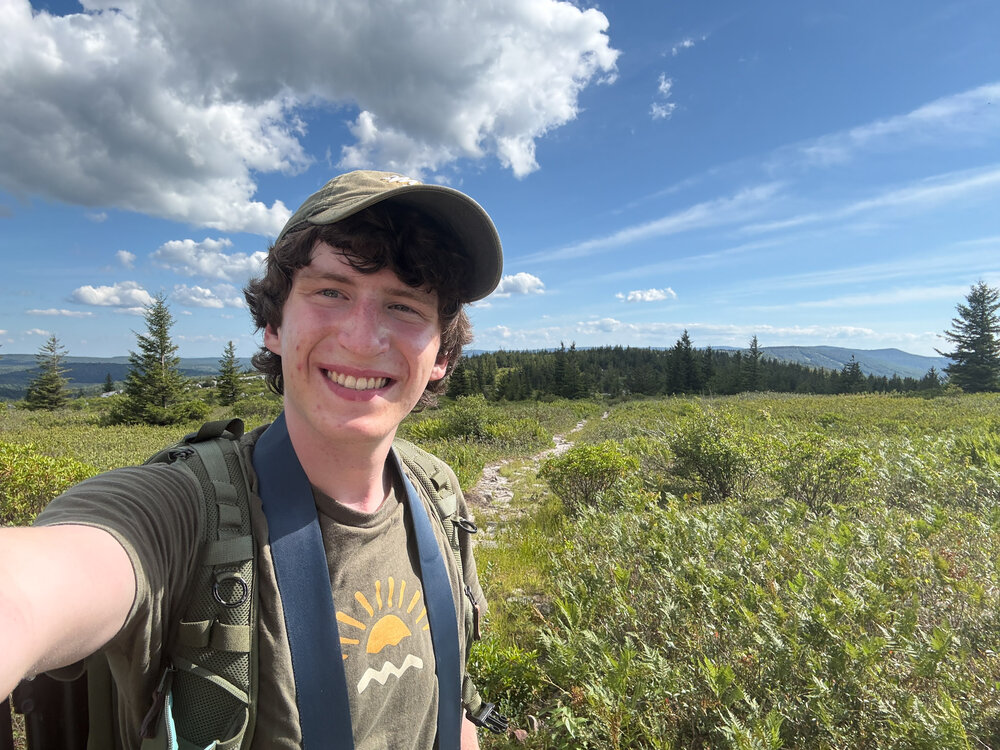
If you need a taste of fall head out to Dolly Sods WV! I went today (I guess yesterday now) and it always amazes me how the Allegheny Front is just a different climate. Drove up from the valley at 82 degrees to the top at 70 degrees. Went on a 12 mile hike and the landscape was beautiful, reminded me of tundra shrubbery I learned about last year in an arctic ecology course. Crossed Red Creek and entered the mud flats for 1 mile which was a bit rough. Otherwise, nearly a perfect day, and would recommend without reservations! (just skip the end of dobbins grade trail and take ravens ridge instead) Driving wasn’t too bad either, 2 hours 35 minutes and the vast majority of it was 4 lane highways (even in WV!). I’ll upload my other pictures later, but here’s one from my phone!
- 1 reply
-
- 2
-

-

-
buy Viagra online: Med Men News - viagra canada
-
Viagra tablet online: MedMenNews - over the counter sildenafil