Search the Community
Showing results for tags 'snow'.
-
 This post is at the seeming urging of multiple models this weekend offering a period of snow to the NYC subforum. Presuming it occurs, it could begin late Thursday the 18th, or it could linger into early Saturday the 20th. The coldest air of the season so far in NYC, may follow on gusty northwest winds next weekend, the 20th-21st. There doesn't seem to be anything definitive per this Jan 14th issuance, except that a period of snow is expected for at least a portion of NYC subforum on Friday with below normal temps. It's a strong positive tilt trough that approaches from the Great Lakes-Ohio Valley late this coming week. Attached the 12z/14 GEFS 500 MB mean left panel and 500 MB ensemble membership right panel. The NWS Sunday 'day' shift ensemble chance of 1/4" or greater snow-ice is attached as well as the 12z/14 EPS 24 hour positive snow accumulation ensembles ending around midnight Friday night. The 18z/14 GEFS was lighter for the same period so I extended the 24 hour positive snow depth ending time to sunrise Saturday whereas the CMCE was faster with the snow so I ended it 00z/20. Overall this Dec-Jan winter, it is my impression the GEFS tends to be conservative forecasting snow, the CMCE more liberal with more abundant qpf as well. I may have to add rain in the tags for the coasts as we draw closer to the proposed thread day... for now the colder solution was favored but uncertainty exists. Title addition 1/17/24 503AM: Event OBS. Tags: added rain/snow mix.
 -
Attached are two 24 hour EPS graphics from the 12z/10 cycle that are significant for D6-7. The CMCE and GEFS are much less of snow risk for the northeast USA, so far. This thread is started because of the several consecutive cycles, although variable placement, EPS persistent snow threat for the I84 or I95 corridor, and it's possible snowfall outcome for NYC. Also is attached the 19z/10n Blend of Models from the NWS as a sketchy idea for I95. Reminders: The CMCE and GEFS are weak with the snow risk. Tags may be adjusted in a few days as it becomes clear whether our NYC subforum only gets a short period of snow/flurries in the wake of a strong windy cold frontal passage with single number-teens wind chill by Wednesday morning, or we realize a nice coastal wave of low pressure that produces hazardous wintry weather for the majority of the NYC subforum, then followed by a shot of the wind driven cold. This system is not as clear cut at D6-7 as previous storm threads in Dec-Jan, so uncertainty exists. [Typo on headline Thread. updated 854PM/10]
-
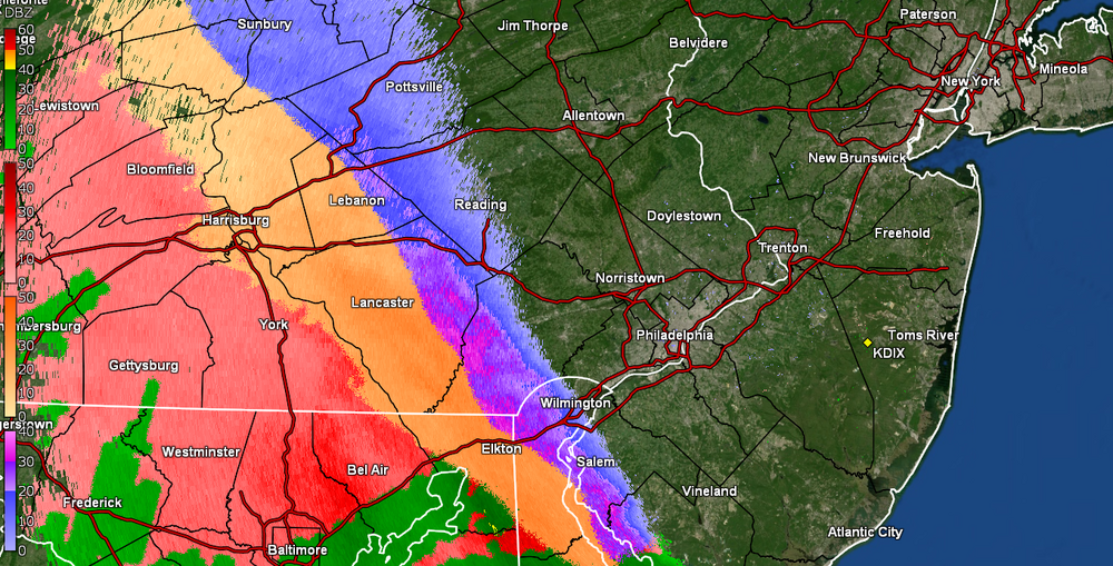
WWA up for the CWA - KYW traffic report earlier this morning had noted several times that it had been snowing down in Baltimore and that was causing some road issues there. Currently 24 here in NW Philly with dp a desert-like 6.
-
The modeled next powerful storm into the Great Lakes region should add around another inch of rain in 6-12 hours Friday night, possibly causing renewed urban, basement and small stream flooding and probably extending on-going mainstem flooding in the NYCsubforum through the weekend. Maximum south-southeast coastal gusts possibly capped around 50 MPH along the shore Friday night but when the storm gets into Canada, backside westerly gusts might hit 50 MPH anywhere in the NYC subforum for brief periods of time later Saturday into Sunday. So some power outages are possible. Coastal flooding does not appear to be a large threat. Snow-sleet-freezing rain is anticipated at the start Friday afternoon-evening along the I84 corridor bordering the northwest portion of NYC subforum with "possible" short duration amounts generally 1/2-2" mainly in the high terrain above roughly 1000 feet. I84 corridor valleys, probably little or no accumulation. Max rainfall from this storm maybe ~2'? This thread will also serve as the OBS thread for this anticipated event.
- 90 replies
-
- 5
-

-
- flooding rains
- damaging wind? squalls?
- (and 2 more)
-
The above hopefully encapsulates the likelihood of two upcoming significant east coast storms. Changes will occur from the some of the attached supporting graphics but we're in line for more significant weather and I'm sort of concerned about flood potential. This time maybe wet snowfall NYC.? Please consider limiting NYC snow enthusiasm with the stats attached from Don, at least until we get Jan 4-5 (if snow is still in the possibilities). It is hoped the Bluewave produced lack of 2" snowfall at CP can be put to bed, but it's possible that next Sundays probable wintry event will shift a little more inland with rain dominating along the coast. The event for the 10th could be brief snow or ice to heavy rain and snow melt, presuming we accumulate anywhere close to the attached 00z/31 EPS prob of 4" axis. Wind damage graphic via the EPS for the 10th... expectations are more of an e-ne wind (nor'easter we hope) for the 7th with gust potential 40-50 MPH along the coast and maybe minor coastal flooding (tide cycles are LOW for this storm). The event around the 10th "may" have stronger winds gusts vicinity 60MPH along the coast and a better chance of coastal flooding (tide cycles 10" higher to start). Power outages possible but impossible to predict without 24 hour confidence on wind gusts/qpf amounts/ptype/temp if and when it snows. This thread was started since I think there is general interest in snow, also flood potential for this weather interested forum. I may comment once/day but it's all yours. OBS for the 6th-7th will go in here. For whatever occurs the 10th...may have to separate out the OBS in a supplemental thread late 9th, but that's 10 days away and at least a portion of these ensemble expectations may be less than out looked through the 00z/31 cycle and therefore less impact and more routine. No guarantees here but definitely worth monitoring. Edited title 1156AM-Jan 6 to include obs and tags added obs and sleet. Edited title 645 AM Jan 8 iso include OBS for Jan 9-10 and removed the ? behind damaging wind.
- 3,610 replies
-
- 11
-
-

-
- snow
- heavy rain
- (and 5 more)
-
 Most of our long range looks are well into December now. Hopefully we can have a better winter than last year, which was an all-time worst here. The first week of the month looks to be near normal temp wise and probably drier than normal, even though CPC favors AN precip.
 -
Carver's spoke of creating an early winter spec thread recently, and after another day in the 70s in August, I figured why not get the ball rolling. This for general long term talk about the potential winter patterns, etc. Right now, the EPO has went negative, it's at -12, and is in the East descending phase. In 2021-22 it fell into the negative in May and stayed deeply negative until the following May. So it should descend throughout winter. Below, average pressure anomalies over NH when the QBO is negative. Higher in the PNA/NAO region, lower over the south and eastern U.S. (These maps may initially appear confusing, since they greens are positive numbers. It just means that the they are higher by those margins over those areas or lower by those margins over those areas when there isn't a -QBO in place. Just keep in mind green = lower pressure and cooler temps during -QBO years) There tends to be higher pressure over the North Pole during a -QBO, which results in a weaker jet stream/polar vortex on average. During an El Nino/-QBO combination our forum region is slightly BN for temps DJF and pressures are quite a bit lower across the Southeast (our storm track). The map doesn't look unlike this for temps, but BN for Texas, Tennessee, North Carolina and up the east coast is more prominent than the CPC map here. Especially over Texas.
-
The downward slide into winter begins. Post your Obs/Discussions here.
-
All mid to long term discussion is in met fall at this point. This should carry us until Nov 20th or so, when December/winter starts showing up on models. Blah weather to begin fall, if the GFS is correct. Lingering heat that clings on like an unwelcome in-law on it. If the GFS is being it's normal, likely ridiculous self, we may be lucky. The Canadian says "what heat?" over the next 10 days.
-
Thought this one was fired up already since fall started a couple weeks ago. Just realized I was posting in the spring/summer thread still. Of course love to keep winter storm obs in the storm threads for later reading all in a single thread. But these are good for daily obs or notable events outside the storm threads. That said, I hit 47.3 this morning after a day time high of 69 degrees yesterday. Pretty similar temperatures for this same period in September 2015 when we got a nice first cold front of the season on 9/13 and had two days of great temps. It was 70/46 on 9/13 and 66/43 on 9/14 that year. Current temp is 71 degrees here, sunny. It was 72 about an hour ago but dropped back a little. In 2015 we never got back above the 84ish range after the front. It had been in the upper 80s for days on end leading into it.
-
 There is likely going to be some warmth during mid-month - and maybe extreme. So, I am not starting this thread w/ any sugar coating. That said, models are sniffing out a cold shot to start this month which wasn't seen on some modeling even 24 hours ago. In life we go one day at a time. Let us not borrow the troubles of tomorrow until they arrive. 12z Yesterday and 12z today of the GEFS.
 -
With some decent consensus between the GFS/NAM/CMC/EURO for flakes, maybe even measurable snow Saturday, figured I’d spread this out from discussion on our longer range looks. Sorry if this thread kills things entirely!
-
Looks like the first ten days or so will be warm, but that is not a lock. After three years of La Nina, we are probably closing-in on our last few months of this ENSO phase. La Nina's often yield warm Januarys, but something makes me think we buck the trend this month for at least part of the month. I have January as AN in my seasonal forecast, but a portion of the last 20 days of the month could be quite cold. I still expect some wild swings this winter w/ a base warm pattern and very cold interludes.
- 923 replies
-
- 1
-
-
- warm start
- cold
- (and 4 more)
-
We will soon find out if the high latitude blocking signatures pay dividends for our area. May need a boat and may also need snow shovels. We'll try separating this into threads by month. If that doesn't work, I will simply switch this to Part I of winter. Have fun and good luck!
- 582 replies
-
- 6
-
-
-
- snow
- freezing rain
- (and 4 more)
-
Here are a few winter outlooks. Feel free to add any others or your own thoughts https://www.noaa.gov/news-release/us-winter-outlook-warmer-drier-south-with-ongoing-la-nina This year La Niña returns for the third consecutive winter, driving warmer-than-average temperatures for the Southwest and along the Gulf Coast and eastern seaboard, according to NOAA’s U.S. Winter Outlook released today by the Climate Prediction Center — a division of the National Weather Service. Starting in December 2022 through February 2023, NOAA predicts drier-than-average conditions across the South with wetter-than-average conditions for areas of the Ohio Valley, Great Lakes, northern Rockies and Pacific Northwest.
-
 Since we do have a variety of forum posters in areas that will see snow/sleet/ZR - at least initially and on the backend, plus there is a flood threat, along with some potential advisory-level winds and possibly record breaking cold, decided to go ahead and make an obs thread. Currently misty and mostly virga and 36 with dp 32 here in NW Philly.
 -
Current obs - Tem 32 with dp 24 and overcast.
-
Day one of met fall, highs in the 70s, humidity fell through the day. Hard to beat after the heat, humidity and rain that ended met summer.
- 167 replies
-
- 4
-
-
- frost
- cold front
- (and 4 more)
-
February discussion for all things winter in the Tennessee Valley Sub-forum. When we have a likely event 2-3 days out we can create an individual thread for said storm. It helps for record keeping purposes as a lot us like to look back on old threads to learn, etc. Hope everyone is doing well.
-
Hi everyone, Thought I’d create a catch-all thread to post, and discuss, some of the most significant winter storms to affect the Southeast U.S. states. With that in mind, I intend to share details regarding many of the historic snow storms that have battered the SE…dating as far back as the 19th century. Moreover, I look forward to reading first-hand accounts of the most memorable events you’ve experienced, first-hand.
-
Welcome to a place for weenies to share snow maps and fantasy storms that will never happen... unless they do, of course. Renew those model subscriptions and get to obsessively tracking those storms that are 16 days out. They say the big ones lock in early... Kicking us off for the season is a nice little run of the 00z EPS control. Still room for this to trend better!
-
January discussion for all things winter in the Tennessee Valley Sub-forum. When we have a likely event 2-3 days out we can create an individual thread for said storm. It helps for record keeping purposes as a lot us like to look back on old threads to learn, etc. Merry Christmas to all as well, I hope everyone has a great holiday.
-
MRX added the Northern Plateau counties to the WWA but mentioned that heavier convective showers are also possible into the Central Valley. Should be fun if you get a band or snow squall. The eastern mountains are golden.
-
454AM Wednesday Jan 12: title and tags adjusted to drop Saturday, focus late Sunday-Monday morning for what appears to be an 18 hour storm of snow-rain-snow. Heaviest snow tends to be modeled west of the I-95 corridor but ensembles still warrant continued concern for the axis of heavy snow including I95. At this point far too uncertain but where it snows for 12 hours, widespread 6+" seems likely. Also a 6 hour period of potential 50 kt inflow gusts is possible for the coasts Sunday morning and if it occurs with the dawn Monday high tide, would result in coastal flooding, magnitude unknown. This does not appear to be a long duration storm (24 hours+) but it should be intense for a few hours Sunday night or Monday morning. Again track uncertain, and sensitive to the intensity of the surface low. There still is opportunity that this will track too close to our area for much snow but there are several days to adjust the track and resultant precipitation type. It does appear there will be a general inch to 1.5 inches of qpf with this system, maybe thunder too. A big storm with large scale impacts entire east coast-Appalachians. The only reason I didn't highly stronger wording for impact, is that this will occur later Sunday and the following Martin Luther King Jr. Holiday. --- At this 6-7 day lead time 8PM Sunday Jan 9 issuance, options are fairly wide open. For now, a light or moderate event 'seems' likely but absolutely not a lock, nor is a heavy event excluded. This event still could be demolished to zero by what happens off New England on the 14th, or what follows between the 19th-22nd. However there already has been discussion the past several days for the coming weekend. Ending 12z/9 the past 6 cycles of the ECMWF op, the last 4 cycles of the CMC GGEM [LI 3 cycles, I84-4 cycles] have some sort of snow event, especially I84. Maybe the GFS via it's 18z/9 cycle is shifting snow emphasis on the 16th for our area instead of bombing off the coast on the 14th? Having reviewed ensembles: 12z/9 EPS/GEFS/NAEFS all have some sort of frozen event is coming to the northeast USA, along and north of I80 including LI. Have added the broad coverage low chance WPC D7 issued at 17z/9, the EPS 24 hour qpf ending 12z/17 and the 12z/EC 850 MB low (GEFS so far has nothing, still favoring the 14th but not as far south and west as previous). NAEFS products for 00z/17 are added including previous 24 hr qpf, 00z sfc temp in C, and the sfc pattern. There will be quite a few model changes-conflicts and this could end up having been a wasted effort... but it seems worthy of further scrutiny as our next possible significant snow or ice event for at least a portion of the NYC subforum.
-
Modeling is favoring the development of some sort of extensive precipitation event along the east coast, with either the first or second of two short waves carving a pretty deep, albeit temporary 500MB trough in the eastern USA between next Friday and Monday. At least until Tuesday the 18th when the results of the 16th-17th are in, lets hold off on single model solution hype. Three graphics added, two from the 08z/16 WPC issuance. Low prob 3+" of snow, and the third was the CPC D8-14 hazard graphic, it paints a small chance of heavy snow just north of I-80 again (just like this 16th-17th event). It also ,not shown here,has a high chance of very cold air here 22nd-28th. 7AM/18 Update: I've updated the thread title-no guarantees our NYC subforum will share in what is coming to the Demarva-Carolinas but it seems models are gravitating to a decent snowstorm for a portion of the mid Atlantic and possibly through southern NYS-southern New England. 718A/21: Changed thread title to add part one was about 150mi too far southeast (slightly less average error for a D5 forecast than NHC on tropical systems). Withdrew wind from the tag. Otherwise the overall intent of the thread remains the same.


