Search the Community
Showing results for 'josh'.
-
I am more like Josh. I love a good snowfall even if it only lasts a couple hours. I'll take nickel and dime stuff anytime over cold and dry. Heavy rates a fun even if brief
-
josh's criteria for heavy is different than ours....
-

Fall 2023 Medium/Long Range Discussion
Chicago Storm replied to Chicago Storm's topic in Lakes/Ohio Valley
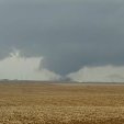
Haven't had much time to discuss it, but as hinted to in a response to a post from Josh post about two weeks ago, after Thanksgiving was a period to watch for wintry conditions...and that is indeed what we have seen unfold. This wintry period is a product of a potent -NAO and Alaskan ridge pairing, which dislodged a PV lobe, sending it south and anchoring around the Hudson. Albeit brief, this is a fairly significant pattern shift than has been seen this new season thus far. We have another significant pattern shift already in the process of unfolding. Will have more on that tomorrow...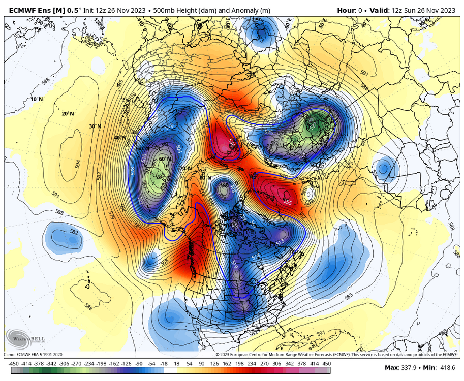
-
Yeah I've been out of the long range loop, so I try to ask around to gather thoughts. One common thing told to me....."ECMWF more overrated than Josh Allen." And I quote lol.
-

Central PA Autumn 2023
pasnownut replied to Itstrainingtime's topic in Upstate New York/Pennsylvania
Absolutely. I'm all about helping the little guy, and we are very fortunate to have a lot of "little guys" in the brewery space in PA. They were at a local pub the other week, and Josh and his crew were really cool. -
Josh Dobbs and Brian Flores defense wins the day. It's definitely different watching a mobile quarterback. Go chargers
-
Larry Cosgrove sees a similarity so far to 2009/2010 djf. (72-73 also but I dunno if anyone knows what kind of winter that was except for josh)
-
Yeah Otis sure redefined RI for us, lol. Tropical Storm to 165 mph Cat 5 with catastrophic gusts to 200 mph in 12 hours. Anyone know if iCyclone was down there recording the storm in Acapulco? Josh is an international, intercontinental hurricane chaser. THAT, would be some intriguing footage for sure!
-
I was hoping Josh would be there. Just to see footage from this. Going to be unreal. If anyone could pull it off, it would be him. Thanks everyone for looking into the radar situation. Too bad we have nothing to look at from that perspective but man this satellite imagery is wow.
-
Josh Morgerman said that he was caught off guard and wouldn't be able to chase Otis. But he's been silent for over 8 hrs on Twitter...and I wonder if he did a quickie and is headed down there. It's possible, he's one of the best.
-
Josh is missing a cat 5. He must be raging.
-
I understand the lake shore counties (LES belts). I agree that over here it makes little sense. Josh could now get three 6.9" snow events in one winter and still not get warning criteria .
-
They are talking about localized sea level rise with the El Nino in the Tropical Pacific from the warmer SSTs not the ongoing global sea level rise. https://climate.nasa.gov/news/3286/international-ocean-satellite-monitors-how-el-nino-is-shaping-up/#:~:text=By October 1997 and 2015,the 1997 and 2015 events. Not all El Niño events are created equal. Their impacts vary widely, and satellites like the U.S.-European Sentinel-6 Michael Freilich help anticipate those impacts on a global scale by tracking changes in sea surface height in the Pacific Ocean. Water expands as it warms, so sea levels tend to be higher in places with warmer water. El Niños are characterized by higher-than-normal sea levels and warmer-than-average ocean temperatures along the equatorial Pacific. These conditions can then propagate poleward along the western coasts of the Americas. El Niños can bring wetter conditions to the U.S. Southwest and drought to regions in the western Pacific, including Indonesia. This year’s El Niño is still developing, but researchers are looking to the recent past for clues as to how it is shaping up. There have been two extreme El Niño events in the past 30 years: the first from 1997 to 1998 and the second from 2015 to 2016. Both caused shifts in global air and ocean temperatures, atmospheric wind and rainfall patterns, and sea level. The maps above show sea levels in the Pacific Ocean during early October of 1997, 2015, and 2023, with higher-than-average ocean heights in red and white, and lower-than-average heights in blue and purple. Sentinel-6 Michael Freilich captured the 2023 data, the TOPEX/Poseidon satellite collected data for the 1997 image, and Jason-2 gathered data for the 2015 map. By October 1997 and 2015, large areas of the central and eastern Pacific had sea levels more than 7 inches (18 centimeters) higher than normal. This year, sea levels are about 2 or 3 inches (5 to 8 centimeters) higher than average and over a smaller area compared to the 1997 and 2015 events. Both of the past El Niños reached peak strength in late November or early December, so this year’s event may still intensify. “Every El Niño is a little bit different,” said Josh Willis, Sentinel-6 Michael Freilich project scientist at NASA’s Jet Propulsion Laboratory in Southern California. “This one seems modest compared to the big events, but it could still give us a wet winter here in the Southwest U.S. if conditions are right.”
-
I looked this storm up early after seeing Josh mention it and it looked like a good storm for alot of areas but I don't recall it. I kept a close eye on snowstorms while I was in florida too. I'll take a Halloween snowstorm for sure. All I remember is rainstorms while I was young trick or treating lol.
-
He can't see your posts anymore. Consider that a sign that you may be trolling too hard as me and josh have been going back and forth for years and he's never put me on ignore... that I know of. While I do enjoy deep snow cover, and may be superstitious when it comes to getting a snowstorm on top of Snowcover, I'll take the warm swings and the risk of sleet if it means the potential for big snows. On the other side I don't mind arctic air if it leads to overachieving clippers, although when its below avg temp wise, clippers seem nonexistent nowadays with the bigger storms suppressed.
-
Josh morgerman is trying to make it to the landfall point seems like a pretty risky proposition. The eye has filled in right before landfall. Likely weakened back to cat 3, but too little too late of course
-
Josh is on this one...
-

Central PA Summer 2023
Itstrainingtime replied to canderson's topic in Upstate New York/Pennsylvania
Maybe when Jim Nantz retires Josh and Tony can be a broadcast team? -
Rodgers last snap? Josh Allen is the new Tony Romo.
-
Maybe Josh should setup on the Isles of Shoals
-
Hurricane Josh successfully penetrated the eye of Idalia.
-
Look for icyclone aka HurricaneJosh aka Josh Morgerman on Twitter. He is trying to figure out where it will make landfall so he can penetrate the eye.
-
Hurricane Josh starting to position himself so he can chase the core of Idalia. I will be interested to see if he can get yet another eye penetration notch on his belt.
-

Tropical Storm Harold
Ed, snow and hurricane fan replied to WxWatcher007's topic in Tropical Headquarters
I see no modeling that gets 91L above a TS, but my mind wouldn't be blown if it makes it to a 65 knot hurricane. Vis shows good outflow in all quads but the S. Not Weenie-casting, if I were it'd be headed for my house with 3 or 6 inches of drought busting rain (if just a Cat 1), or a major S of Port Lavaca with Reed Timmer and Josh Morgerman chasing it. With at least outer bands raining on my yard. None of that will happen with 91L. -
You are a rain magnet like Josh's snow magnet