yoda
-
Posts
62,102 -
Joined
Content Type
Profiles
Blogs
Forums
American Weather
Media Demo
Store
Gallery
Everything posted by yoda
-

-
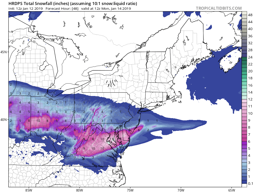
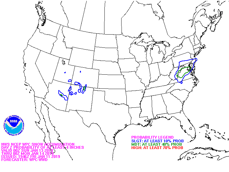
WSW FOR DCA AND INTO MARYLAND
-
12z HRDPS .75" QPF at DCA lol EZF over an inch... BWI around 0.4 or so
-
From WPC
-
You can find the FV3 much faster here: http://mag.ncep.noaa.gov/model-guidance-model-area.php Click on GFS... it is the FV3 on there
-

Southern MD / Lower Eastern Shore weather discussion
yoda replied to PrinceFrederickWx's topic in Mid Atlantic
No side dishes like extra dendrites or heavy DGZ to go? -
1162 tornadoes April 4th
-
Congrats to all... glad to see you all got crushed with heavy snow
-
Congrats all... hope you are all enjoying the snow
-
I echo this... while we complain up north, hope you guys are able to get into the action and get some good snow out of this storm.
-
Here's the Day 7 precip and SLP position for the 00z UKIE for you guys:
-
Tbh, I thought the 06z and 18z EURO runs only go out to 120?
-
DCA: Nov 8th BWI: October 26th IAD: October 22nd RIC: Nov 16th Tiebreaker: 5.76"
-
WPAC, Indian Ocean, and Southern Hemisphere Tropical Cyclones
yoda replied to 1900hurricane's topic in Tropical Headquarters
Wow... everyone has to see this https://mobile.twitter.com/StuOstro/status/1044253347157553154 -
@nrgjeff Mod risk... good luck!
-
Day 2 Convective Outlook NWS Storm Prediction Center Norman OK 1236 PM CDT Thu Jul 19 2018 Valid 201200Z - 211200Z ...THERE IS AN ENHANCED RISK OF SEVERE THUNDERSTORMS FOR SOUTHERN IL/IN...CENTRAL/WESTERN KY...MIDDLE/WESTERN TN...NORTHERN MS/AL... ...SUMMARY... Scattered severe thunderstorms associated with large hail, wind damage and a tornado threat will be possible Friday afternoon and evening across parts of the MIssissippi, Ohio and Tennessee Valleys. ...Synopsis... An anomalously strong deep layer trough and associated surface cyclone are expected to move southeastward from the upper Midwest into portions of the lower Great Lakes on Friday. The surface pattern will be complicated by one or more convectively-induced outflow boundaries, with a synoptic-scale surface trough/cold front expected to progress eastward south of the surface low through the period. A stout EML will spread eastward from the southern Plains over rich low-level moisture, resulting in a volatile thermodynamic environment developing over portions of the MS/TN/OH River Valleys and the Midwest. ...MS/TN/OH River Valleys into the Midwest... A potentially significant severe thunderstorm episode is possible across portions of the MS/TN/OH Valleys and the Midwest on Friday, though considerable uncertainty remains regarding convective evolution through the period. One or more clusters of convection will likely be ongoing Friday morning, though the remnants of these clusters are expected to push east through the day, allowing for moderate-to-strong destabilization in their wake. The strongest focus for convection will be the surface trough moving through IL/IN/OH, though this area will be somewhat removed from the stronger shear and instability, especially with northward extent. Foci for convective initiation will be more subtle further south and west, but the environment will also be much more volatile, with strong instability (MLCAPE of 2500-4000 J/kg possible) and effective shear (45-60 kt) in place. Scattered thunderstorms are expected to develop during the afternoon, potentially along the trailing surface boundary and also evolving out any early day elevated convection. Initially discrete storm modes will favor large hail (potentially greater than 2 inches in diameter), along with damaging wind gusts and a tornado or two. With time, evolution into one or more upscale-growing clusters is expected into the evening. Any such clusters would be capable of producing damaging wind swaths as they propagate to the southeast. ...MAXIMUM RISK BY HAZARD... Tornado: 5% - Slight Wind: 30% - Enhanced Hail: 30% SIG - Enhanced ..Dean/Dial.. 07/19/2018
-
@nrgjeff @jaxjagman
-
LMK was going all in in morning disco it would appear
-
Then you will like how SPC went ENH: Day 2 Convective Outlook NWS Storm Prediction Center Norman OK 1227 AM CDT Thu Jul 19 2018 Valid 201200Z - 211200Z ...THERE IS AN ENHANCED RISK OF SEVERE THUNDERSTORMS ACROSS PARTS OF THE OHIO AND TENNESSEE VALLEYS... ...SUMMARY... Scattered severe thunderstorms associated with large hail, wind damage and a tornado threat will be possible Friday afternoon and evening across parts of the Ohio and Tennessee Valleys. ...Ohio and Tennessee Valleys... An upper-level trough will move into the Ohio and Tennessee Valleys on Friday as an unseasonably strong mid-level jet moves through the southwestern side of the system. At the surface, a low is forecast to move east-southeastward across northern Illinois during the day as a cold front advances eastward across the mid Mississippi Valley. Ahead of the front, a very moist airmass should be in place with surface dewpoints in the lower 70s F. This should enable a corridor of moderate to strong instability to develop ahead of the front by afternoon. As low-level convergence increases along the front, thunderstorms are forecast to form during the early to mid afternoon in the mid Mississippi Valley with the storms moving southeastward across the Ohio and Tennessee Valleys during the late afternoon and early evening. Forecast soundings for Paducah, KY, Evansville, IN and Louisville, KY at 00Z on Saturday show MLCAPE values of 2500 to 3000 J/kg, 0-6 km shear of 40 to 50 kt and steep mid-level lapse rates. This environment should be favorable for supercells with large hail. Hailstones of greater than 2 inches will be possible with the most intense cells. As the low-level jet strengthens during the early evening, 0-3 km storm-relative helicity is forecast to reach the 200 to 250 m2/s2 range. This should be enough for a tornado threat with the more dominant supercells. Storm coverage is expected to increase markedly by early evening as an MCS organizes across the Ohio and Tennessee Valleys. In response, the wind-damage threat should gradually increase during the late afternoon and early evening as supercells or bowing line segments move southeastward across the instability corridor. At this time, the models are in good agreement concerning Friday's scenario. The environment will likely support a substantial severe threat across the Ohio and Tennessee Valleys so this outlook includes an upgrade to enhanced risk. ...MAXIMUM RISK BY HAZARD... Tornado: 5% - Slight Wind: 30% - Enhanced Hail: 30% - Enhanced ..Broyles.. 07/19/2018
-
Through the first 15 days of July (and in fact, the 16th also), only a trace of rain was observed at Reagan National Airport. This is the only time on record, dating back to 1871, that no measurable rain fell in the first 15 days of July. The old low benchmark of 0.08" was set in 1900. Normal rainfall for the first 15 days of July is 1.86 inches, and back in 1905, the wettest first 15 days of July brought 7.05" of rain. https://www.weather.gov/lwx/dryjuly2018
-
Central/Western Medium-Long Range Discussion
yoda replied to andyhb's topic in Central/Western States
New Day 1 has enhanced risk... 30 percent wind -
I don't have any threads saved that I know of, but I'll check to see if i have anything on my old flash drives or saved on my computer somewhere
-
Thank you for looking that up for me - I greatly appreciate it
-
Rodney, Topper Shutt on the 6 o'clock news stated that if DCA hits 80 degrees tomorrow, it would be the earliest 80 degree record in DCA history - prior record was Feb 24, 1930. Didn't we have an 80 degree temp in Jan or Feb of 1998 during the 1997-1998 super el nino?
-
7 day map had you over an inch http://water.weather.gov/precip/index.php?analysis_date=1518393600&lat=38.9337750000&location_name=MD&location_type=state&lon=-77.2668460000&precip_layer=0.75&product=observed&recent_type=today&rfc_layer=-1&state_layer=0.75&hsa_layer=-1&county_layer=0.75&time_frame=last7days&time_type=recent&units=eng&zoom=7&domain=current