yoda
-
Posts
62,102 -
Joined
Content Type
Profiles
Blogs
Forums
American Weather
Media Demo
Store
Gallery
Everything posted by yoda
-
Just measured around an inch here in West Springfield... I'm gathering that conforms to other obs in the area near me?
-
Does this signify better ratios or just that the column is very good?
-
Area of precip moving west in WV? Uh oh
-
-
Looks better for everyone on 18z GFS as well... good luck to you
-
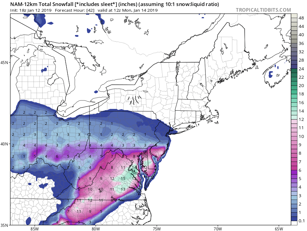
18z GFS suggests 2-3 inches across region by 06z SUN
-
Right down towards me and DC as well as you so its 100 percent right lol
-
18z NAM being the NAM... but looks nice

-
Its still snowing at 2am Monday morning... light to mod band along i95 lol
-
Still snowing nicely across the region at 00z MON (7pm SUN) per 18z NAM
-
FWIW, DCA approaching 0.5" QPF by 12z SUN per 18z NAM
-
I know... just surprised that it came up. I guess there is a warm nose somewhere
-
Hmmm URGENT - WINTER WEATHER MESSAGE National Weather Service Baltimore MD/Washington DC 222 PM EST Sat Jan 12 2019 MDZ016-VAZ036>038-050-055>057-130330- /O.CON.KLWX.WS.W.0002.190112T2100Z-190113T2300Z/ Charles-Nelson-Albemarle-Greene-Orange-Stafford-Spotsylvania- King George- 222 PM EST Sat Jan 12 2019 ...WINTER STORM WARNING REMAINS IN EFFECT UNTIL 6 PM EST SUNDAY... * WHAT...Heavy snow and some ice. Total snow accumulations of 4 to 8 inches and up to one tenth of an inch of glaze ice expected. * WHERE...Portions of southern Maryland and central and northern Virginia. * WHEN...Until 6 PM EST Sunday.
-
The ZFP's got a lil odd... freezing rain and sleet was introduced down there so that is probably why
-
-
-
What about the 12z WRF-NMM? This is based off the parent NAM correct?
-
Flurries here or very very light snow falling
-
Always nice to see in the ZFP's Fairfax- Including the cities of Reston, Herndon, Annandale, Centreville, Chantilly, McLean, and Franconia 114 PM EST Sat Jan 12 2019 ...WINTER STORM WARNING IN EFFECT UNTIL 6 PM EST SUNDAY... .THIS AFTERNOON...Snow. Snow accumulation around an inch. Highs in the lower 30s. Southeast winds around 5 mph. Chance of snow near 100 percent. .TONIGHT...Snow. Snow may be heavy at times after midnight. Additional snow accumulation of 3 to 5 inches. Lows in the upper 20s. East winds around 5 mph. Chance of snow near 100 percent. .SUNDAY...Snow, mainly in the morning. Snow may be heavy at times in the morning. Additional snow accumulation of 2 to 4 inches. Highs in the lower 30s. Northeast winds 5 to 10 mph. Chance of snow near 100 percent. .SUNDAY NIGHT...Snow likely, mainly in the evening. Lows in the mid 20s. North winds 5 to 10 mph. Chance of snow 70 percent. .MONDAY...Partly sunny. Highs in the mid 30s. North winds around 5 mph.
-
Apparently I was prescient in my post awhile back about warnings being extended to the MD/PA border... just two hours early I was yes yes
-
Radarscope works for me pretty well
-
00z run for ref
-
Not really
-
Could someone explain what CSI banding is real quick? Its mentioned in the LWX AFD... is that like thundersnow?
-
Sorry, been up all morning at the grocery store and working around the house. I didnt see the upgraded warning posted so I just said it. My bad. Back on topic, I like the trends of the meso models