yoda
-
Posts
62,102 -
Joined
Content Type
Profiles
Blogs
Forums
American Weather
Media Demo
Store
Gallery
Everything posted by yoda
-
Good to see you all getting some more decent snows... just have it include us some more next time
-
Good luck down there all... Hope you get some decent snows
-
This thread will have a drought of posts
-
Tornado warning up by RIC metro
-

The December to Remember 7th-8th blue turd winter threat thread.
yoda replied to lilj4425's topic in Southeastern States
Meteocentre goes out to 144... but precipitation and h5 only goes out to 72 -
WPAC, Indian Ocean, and Southern Hemisphere Tropical Cyclones
yoda replied to 1900hurricane's topic in Tropical Headquarters
Not sure if where this goes... so if not here please tell me where -
Best Mid-Atlantic winter storm of the last 40 years
yoda replied to PrinceFrederickWx's topic in Mid Atlantic
10 16 09 13 00 96 I think that makes sense... was out of town for 96... anything before that I don't remember/too young to remember -
Thanks all of you for putting this stuff together
-
-
-
Southern MD / Lower Eastern Shore weather discussion
yoda replied to PrinceFrederickWx's topic in Mid Atlantic
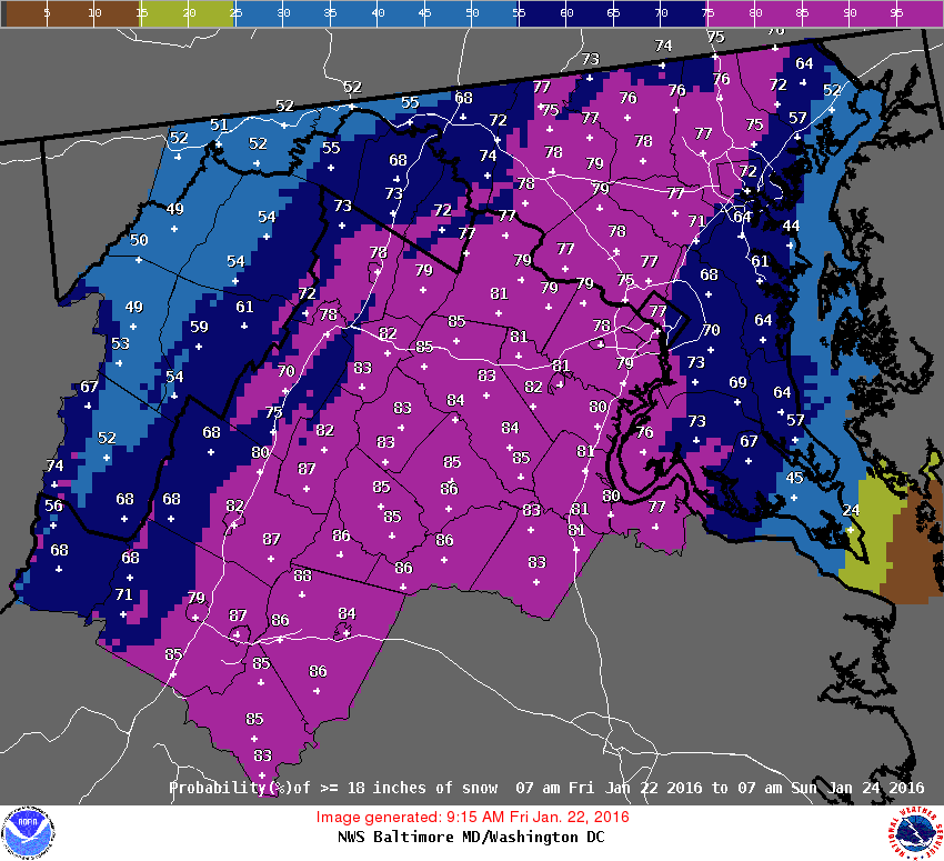
http://www.instantweathermaps.com/NAM-php/showmap-conussfc.php?run=2016012112&time=PER&var=ASNOWI&hour=060 -
Southern MD / Lower Eastern Shore weather discussion
yoda replied to PrinceFrederickWx's topic in Mid Atlantic
SPECIAL WEATHER STATEMENT NATIONAL WEATHER SERVICE WAKEFIELD VA 1032 AM EST SUN JAN 17 2016 VAZ048-060>062-064>069-079>083-087>090-509>520-171800- FLUVANNA-PRINCE EDWARD-CUMBERLAND-GOOCHLAND-CAROLINE-MECKLENBURG- LUNENBURG-NOTTOWAY-AMELIA-POWHATAN-BRUNSWICK-DINWIDDIE- PRINCE GEORGE-CHARLES CITY-NEW KENT-GREENSVILLE-SUSSEX-SURRY- JAMES CITY-WESTERN LOUISA-EASTERN LOUISA-WESTERN HANOVER- EASTERN HANOVER-WESTERN CHESTERFIELD-EASTERN CHESTERFIELD- WESTERN HENRICO-EASTERN HENRICO-WESTERN KING WILLIAM- EASTERN KING WILLIAM-WESTERN KING AND QUEEN- EASTERN KING AND QUEEN- INCLUDING THE CITIES OF...FARMVILLE...GOOCHLAND...SOUTH HILL... CREWE...LAWRENCEVILLE...PETERSBURG...HOPEWELL...EMPORIA... WAKEFIELD...WILLIAMSBURG...LOUISA...MINERAL...ASHLAND... MECHANICSVILLE...MIDLOTHIAN...BON AIR...CHESTERFIELD...CHESTER... COLONIAL HEIGHTS...RICHMOND...SANDSTON...AYLETT...KING WILLIAM... WEST POINT...KING AND QUEEN COURTHOUSE 1032 AM EST SUN JAN 17 2016 ...SNOW AFFECTING CENTRAL AND SOUTH CENTRAL VIRGINIA... SNOW WILL CONTINUE ACROSS CENTRAL AND SOUTH CENTRAL VIRGINIA THROUGH EARLY AFTERNOON. SNOW WILL REDUCE VISIBILITY TO ONE MILE OR LESS. ACCUMULATION WILL AVERAGE AROUND ONE INCH AND ACCUMULATE MAINLY ON THE GRASS AND ELEVATED SURFACES. MOTORISTS SHOULD BE ALERT FOR REDUCED VISIBILITY DUE TO AREAS OF SNOW. DRIVE AT REDUCED SPEEDS AND USE LOW BEAM HEADLIGHTS. -
Central/Western Medium-Long Range Discussion
yoda replied to andyhb's topic in Central/Western States
From Broyles... Day 4 OTLK: -
Best Mid-Atlantic winter storm of the last 40 years
yoda replied to PrinceFrederickWx's topic in Mid Atlantic
Anything before 2003 I don't remember much of, so I am basing my ratings after that storm. In '96, I was stuck in FL for my grandparents' 50th wedding aniversary, so I missed that storm completely... it was hell to get a flight back into DCA from JAX... Jan 2000 -- All I really remember was listening to my weather radio and hoping beyond hope Bob Ryan was wrong (that we would get grazed by the SLP at best, one inch at most) and hearing my weather radio go off ~10PM and WSWarnings being issued for 4-8 inches for us... then 6-12 later that night and so on. I remember running downstairs to my dad and telling him -- he didn't believe me until he saw the warnings himself 2009-10 season as a whole was the best... I remember being on the computer alot where I work and not getting much done during the December storm and the February storms since I was tracking the storms so much... luckily most of the admin knows I am a "weather nerd" so they let me do some model watching as long as I did some work If I had to pick one, probably the Feb 5-6 storm first -
96 we were stuck in FL (JAX) for a family vacation and it was tough getting back in... we got one of the last flights back from RDU to DCA. 09-10 was awesome for both storms, both the Dec and Feb ones.