yoda
-
Posts
62,102 -
Joined
Content Type
Profiles
Blogs
Forums
American Weather
Media Demo
Store
Gallery
Everything posted by yoda
-
And of course... if you wish to hug and accept the UKMET snow weenie map
-
850 0c line doesn't cross our region till around 20z... doesn't go above 32 till 22z/23z 18z WED 6hr radar shot -- notice the QPF
-
FWIW, UKMET is a pounding
-
It's even better than 18z lol
-
Sounding at 18z at DCA looks isothermal up at 700mb... so just barely hanging on to snow if its pounding IMO
-
If we can keep the heavy rates, I think we can hold off the flip until 18z
-
Updated AFD from LWX as of 8:57pm:
-
What does that mean?
-
Ripping snow at 16z WED in DCA at the very end of the 22z HRRR
-
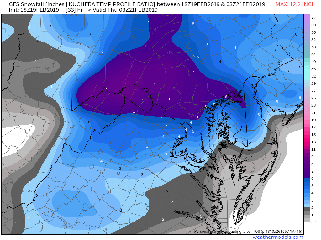
18z GFS Kuchera is 4" from EZF north

-
Tornado warning for DeKalb, Rutherford, Wilson and Cannon counties until 3:15pm
-
If true, that's just... wow
-
Drip drip drip is what's going on outside right now for him
-
But I thought you were only getting 2 inches? And the GFS only showed 0.3" QPF? What happened?
-
I hope so as well, but didnt you guys up north do well in the November storm?
-
Damn, I didnt think you would reach 10"... congrats
-
My 8.5 sounds good then
-
As of 1pm
-
@nj2va @mattie g Those around me, how much do you have at 6pm? I measured just over 8.5
-
Tries for another .2 to. 3 of QPF near DCA lol
-
https://mobile.twitter.com/antmasiello/status/1084547772060188673 https://mobile.twitter.com/islivingston/status/1084547798052278272
-
Oooh https://mobile.twitter.com/antmasiello/status/1084546839486054400
-
Some have already closed... though they are the usual
-
Afternoon LWX AFD:
-
https://mobile.twitter.com/islivingston/status/1084542703508119557