yoda
-
Posts
62,102 -
Joined
Content Type
Profiles
Blogs
Forums
American Weather
Media Demo
Store
Gallery
Everything posted by yoda
-
LWX had a great write up in their evening AFD that I posted in the catchall severe thread... dunno what Wakefield is saying though
-
-
@high risk @Kmlwx @C.A.P.E. @Eskimo Joe Excellently written updated evening AFD (posted at 951 PM) about the threat for late tomorrow into tomorrow night by the LWX mets... excellent points both for and against
- 2,802 replies
-
- 3
-

-
- severe
- thunderstorms
- (and 4 more)
-
But it says "some thunderstorms"... take out the damaging wind gusts part and it makes it seem like they are saying some thunderstorms will be capable of producing a tornado. I like that it says that spotter activation is likely too
-
Interesting wording in the HWO about late tomorrow into tomorrow night. Usually it says something like an isolated tornado is possible... but instead says this:
-
Yeah its Margusity... but still, that's not a good map from the 18z HRRR... which I mentioned in a post above https://mobile.twitter.com/HenryMargusity/status/1117203973465870336
-
So instead of posting something, @Eskimo Joe would rather just lol every post... impressive Surprised he didnt lol @Kmlwx post above
- 2,802 replies
-
- 2
-
-
- severe
- thunderstorms
- (and 4 more)
-
18z HRRR at LR, so take it FWIW, but that radar image doesnt look good around 03z to 04z... string of sups
- 2,802 replies
-
- 1
-

-
- severe
- thunderstorms
- (and 4 more)
-
12z NAM NEST also has PDS TOR soundings showing up across LWX CWA from 00z to 08z MON
- 2,802 replies
-
- 2
-
-
-
- severe
- thunderstorms
- (and 4 more)
-
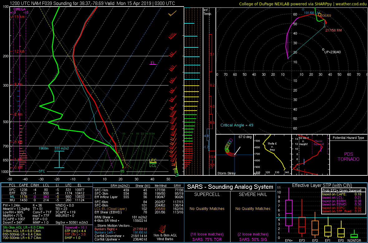
12z NAM in Augusta/Rockingham counties at 03z MON
- 2,802 replies
-
- 1
-
-
- severe
- thunderstorms
- (and 4 more)
-
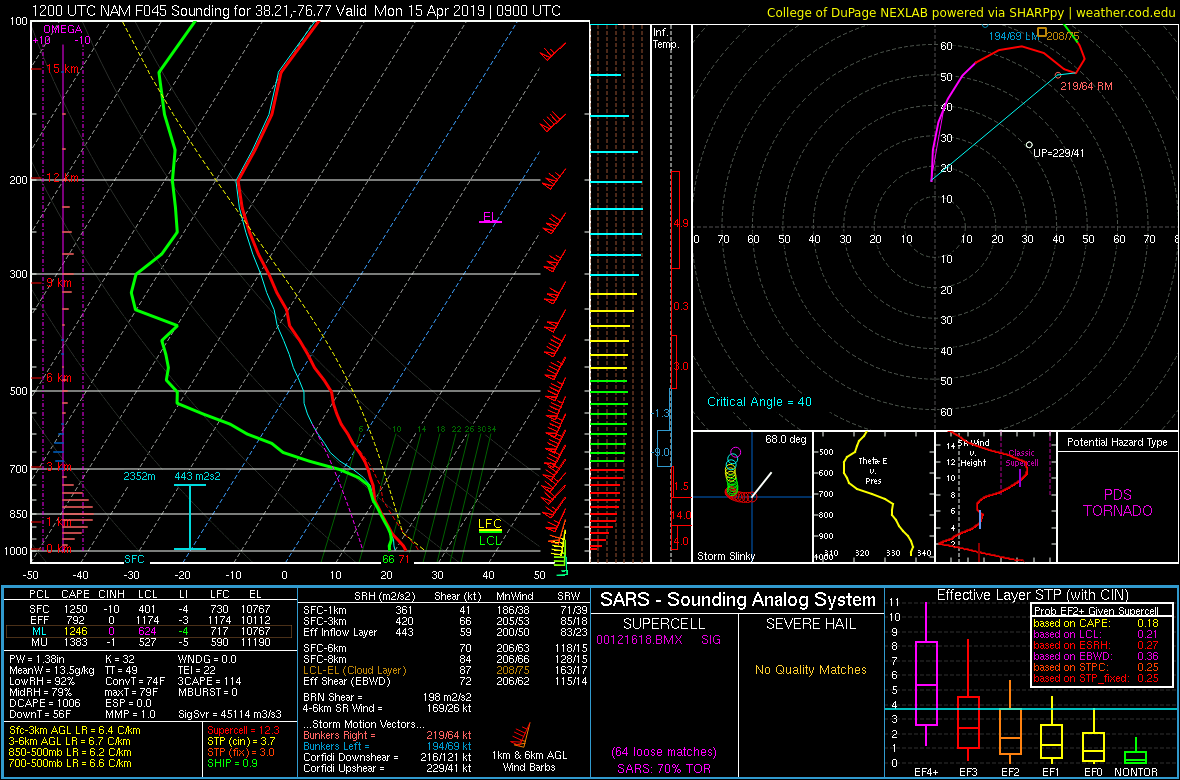
12z NAM in SW St. Mary's County at 09z MON

- 2,802 replies
-
- 1
-
-
- severe
- thunderstorms
- (and 4 more)
-
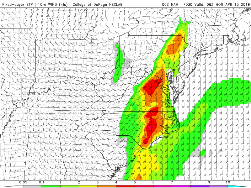
@Kmlwx @high risk SPC 12z HREF ensemble mean paints fixed layer STP of 4 to 7 across the region from around 03z to 08z MON Also shows 40% or greater ensemble probability of fixed layer STP >3 from 03z to 08z MON
- 2,802 replies
-
- 1
-
-
- severe
- thunderstorms
- (and 4 more)
-
Falling asleep - yes I know its 4am - and a loud rumble of thunder woke me back up
-
New Day 2 has SLGT almost to the i95 corridor and west for late Sunday into Sunday night
-
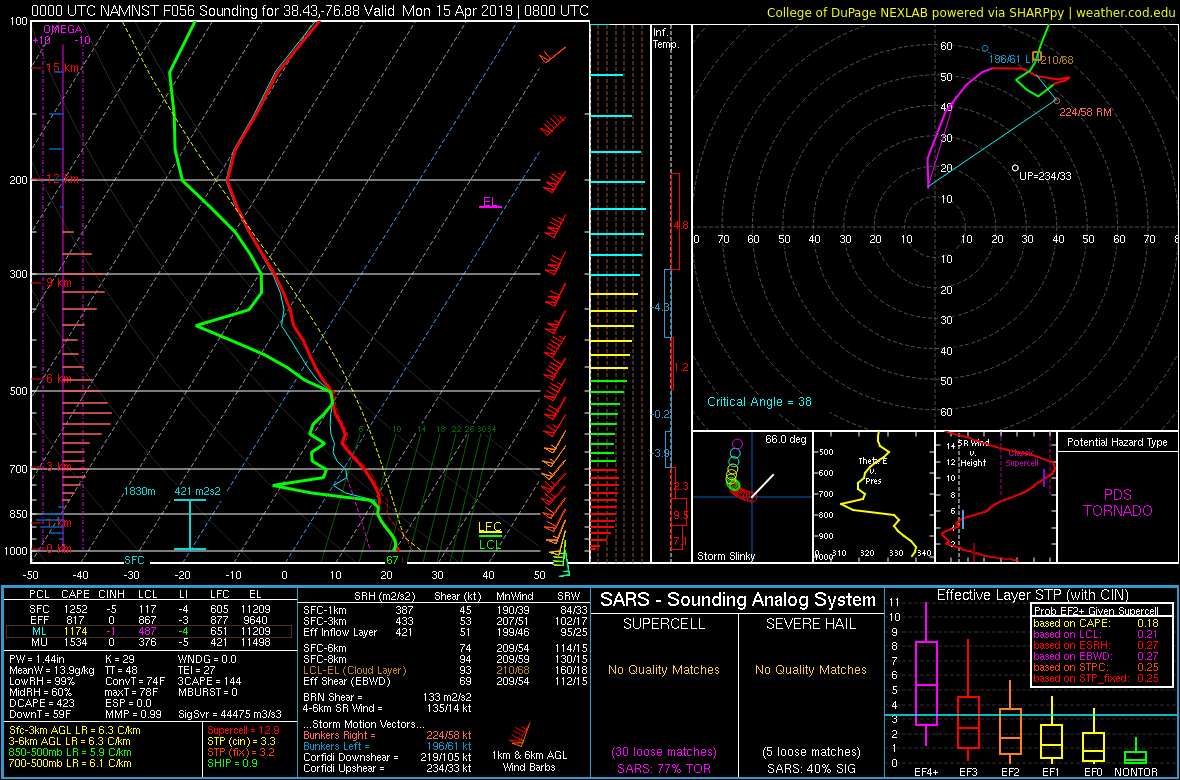
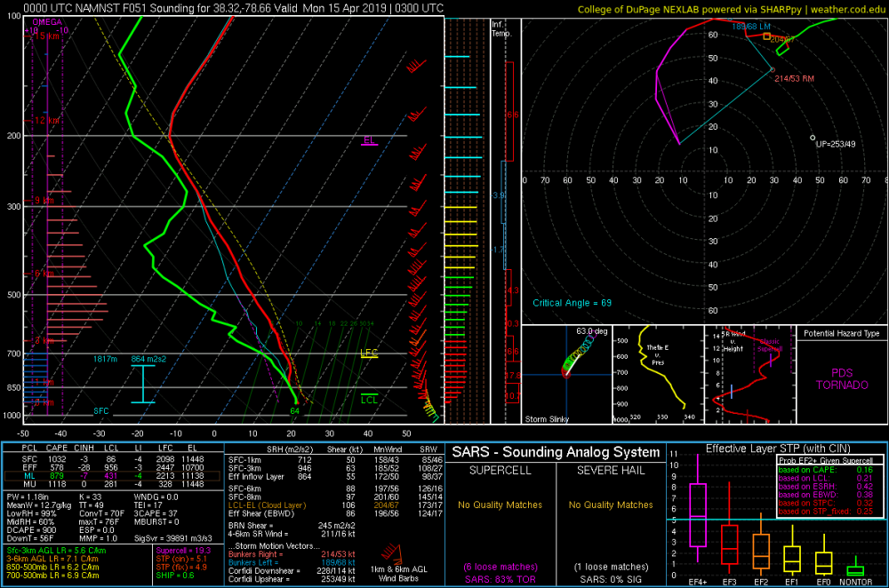
Charles County MD at 08z MON aka La Plata tornado zone from the 00z NAM NEST

-
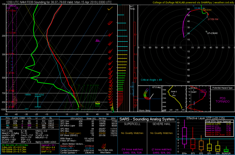
Def agree and good post. I edited my post above and posted a sounding at 03z MON a little bit NW of CHO... prob overdone but PDS TOR lol
-
Just NW of CHO... Rockingham/Greene/Albermarle county area... first of the year lol
- 2,802 replies
-
- 1
-
-
- severe
- thunderstorms
- (and 4 more)
-
@high risk What do you think of the 00z NAM NEST tonight? STP looks to be pretty high across the region from 02z to 08z MON... looking at it on weather.cod.edu
-
TOG near Fuquay-Varina... was decent for a moment looking at CC ETA: Solak posted image above
-
Tree damage reported in Cumberland with the severe thunderstorm in W MD
-
STW up in W MD and extreme N WV... winds to 60mph
-
Afternoon AFD from LWX seems to hint at that:
-
HWO does mention risk... even states an isolated tornado cannot be ruled out due to hodograph 12z NAM seems to also have two distinct "threat" periods... one around 00z and one around 09z looking at the soundings
-
SPC day 1 OTLK has marginal risk for good amount of the LWX CWA... 5% hail and 5% wind
-
LWX seems to still like late Sunday into Sunday night for some possible severe