nrgjeff
-
Posts
4,200 -
Joined
-
Last visited
Content Type
Profiles
Blogs
Forums
American Weather
Media Demo
Store
Gallery
Everything posted by nrgjeff
-
They write a 20% of watch issuance. So you're saying there's a chance... My only goal is shelfie. Not much turning with height. However I like any day in Dixie with good visibility!
-
Thank you for the update and foliage forecast. We were going to try to get out this weekend, but the last weekend of October is probably better for us. I figure above 3K ft is good this weekend. Thanks to ample moisture in spring and summer, and finally decent diurnal trends, I'm hoping for a great show in the valleys and even urban areas again like last year. Chatty is definitely after Halloween.
- 167 replies
-
- 1
-

-
- frost
- cold front
- (and 4 more)
-
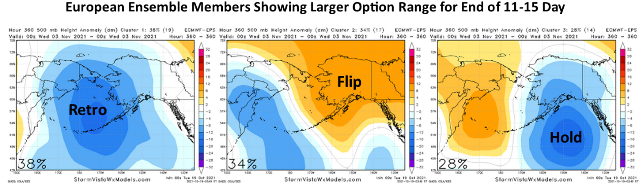
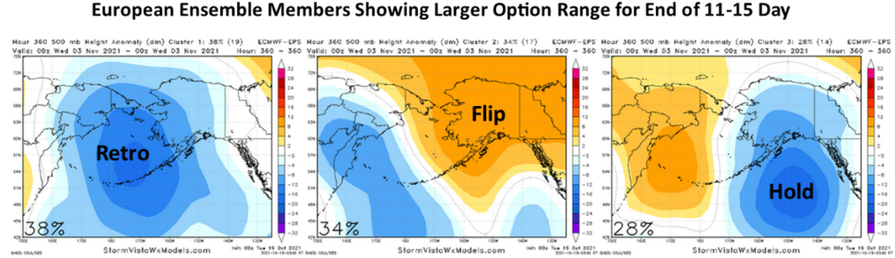
Weekly charts are split 50/50 on this mid-November pattern flip. Southeast is shown normal. Clusters show a mix of warm cold and blah. North stays warm which is the source. End of the Ensembles shows an equally undecided mess. Now we all know, if something can go wrong - it will. Probably a blend of Hold and Retro (but not enough retro for +PNA). Continue warm. Not a forecast. Mostly cynical venting. Moderator / Admin: Possible to move Monday and Tuesday posts to the pinned forecast thread. I elected to post here in line with the current conversation.
- 167 replies
-
- 1
-
-
- frost
- cold front
- (and 4 more)
-
Best deal is -PDO and -AMO. Then instead of a SER with the PDO, the jet stream is pretty much buried all winter across the South. The two multi-decadal indices are about 15 years out of phase with around 30 year phases each. Last time they lined up with mid-60s to early 80s. Did somebody say it used to snow then? About 15 years ago I thought they might line up again as the -PDO took hold. Then it let go (+PDO years) which got some cold in here from 2007-2011. However the +AMO never wants to let go. Right now all I see is warm SSTs across the northern hemisphere except La Nina. Barf!
-
Latest MD mentions possible watch downstream KY/TN. Also notes 850 mb and I not 925 mb will increase in strength toward evening. SPC leaves the door open for either severe or tornado box downstream. Boundary lurks from Dyersburg toward Clarksville. Said west-east boundary should promote more SRH than the junk cold font.
-

Fall 2021 Thread (September, October, November)
nrgjeff replied to Carvers Gap's topic in Tennessee Valley
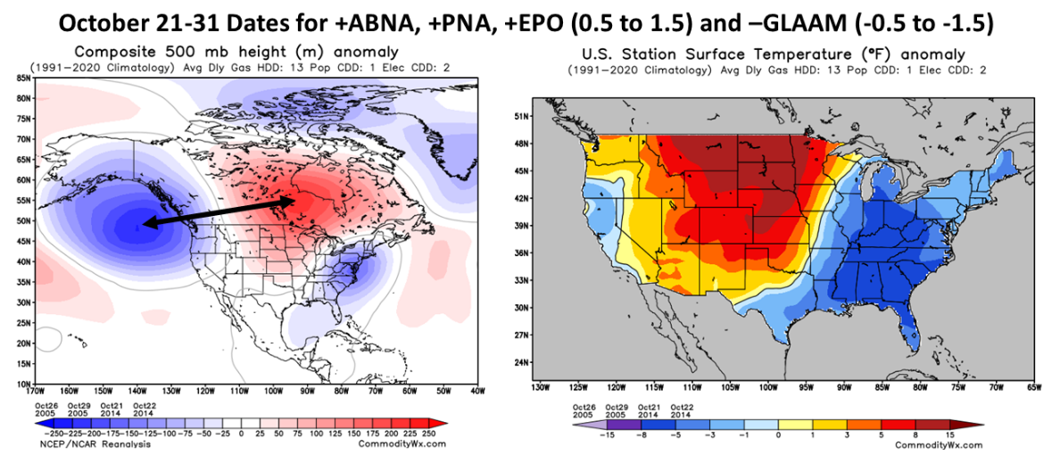
Yeah the +PNA is forecast on most models. It's a cold signal here. Source region means it could be normal vs cold; however, that's lovely fall compared to recent wx. While the 500 mb plots look cold, 2m T forecasts are blah. Makes sense with the North much warmer than normal. Often that pattern is cloudy cool here. However northwest flow should mean more sunny mild days and cool nights. Can we have an order or three of that? We need a mix of sunny and cloudy days for fall foliage. Sunny is always more enjoyable. However for photography cloudy has some advantages. Eh forget that more sun always! -
Agree it'll be tough to get a strong La Nina. Energy content looks very low (strong if Ts upwell efficiently) however it's doubtful. Reason I doubt strong Nina is due to the tendency for convection to poke out of the classic Nina regions to the Dateline. Right there would be a cooler MJO phase. In the mid-long term it disrupts evolution to a strong Nina. So while I favor the weak-mdt La Nina, stormy Mid-South, I'm bearish warm Great Valley. QBO continues to fall, which could help esp Mid-South. We like rate of fall better than bottoming out. Good phase if it can impact things.
-
SPC will probably keep the 5% for West Tenn. Boundary intersection is already set up around Dyersbug, TN. The LLJ will be a bit veered; however, should be just enough SRH right on the boundary with any right mover. Moisture will pool on the boundary. Terrain is great west of town, and OK east for a bit before rolling too much. Jog north into KY would be dreadful terrain. Finally south toward Jackson, TN is doable. Wish I'm there! MD leans severe box, but it might depend on who issues and coordination with WFOs. Also might save it for a small tornado box northeast of there later.
-
2021-2022 Fall/Winter Mountains Thread
nrgjeff replied to BlueRidgeFolklore's topic in Southeastern States
Fall Grand Entrance should include cool temps and foliage working down the mountain quite well. I'm guessing still above 3,000 FT though we have not been out yet. Will we have a separate Foliage thread this year? Looking ahead, we may ski right before Christmas. Wed-Fri. Question is Saturday. Christmas is on a Saturday. Would the ski areas be ludicrous crowded (Saturday) or chill (family holiday)? I'm guessing typical Saturday. Can anyone advise? Thank you and happy fall foliage! -
Fall/Winter Banter - Football, Basketball, Snowball?
nrgjeff replied to John1122's topic in Tennessee Valley
Oh my look at this! Not a forecast, just banter. Please don't share outside this forum. Snow on Halloween again?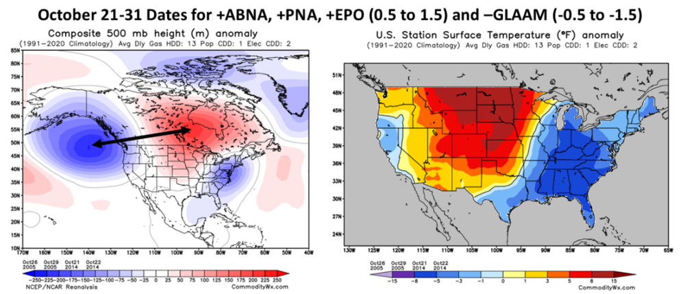
-
I'm seeing a mild winter again. Can't sugar coat that La Nina may over-shoot weak category. IOD is also in a crap phase for the Southeast US including the Valley. QBO actually dropping, vs the fake dip, could help. This would be the second time a fake followed by real drop was the cycle, going back a few years for the two cycles. I'm also hearing strato rumblings, but October is too early to use the tool. Mid-autumn warmings are wasted. One would look for action in November. Note I fell way behind the long-range threads and don't expect to catch up. I will join those conversations after checking the last page or two, starting on or after Tuesday. Been out for six weeks with the birth of our second child! Regarding my overall mild feel for winter, maybe spring severe will be interesting.
-
Starting off Fall Break with a bang! Minimal probabilities, but it's better than the summer doldrums. No special plans from Chattanooga. Who wants to take the over/under for Cullman, AL? https://www.spc.noaa.gov/products/watch/ww0513.html expires 10pm Central October 6, Wednesday.
-
TN valley heavy rain/flooding week of whenever
nrgjeff replied to janetjanet998's topic in Tennessee Valley
Thank you for posting. That's just awful. TVA employees impacted, but I know it's much worse for many people. Fatalities were shocking not associated with vehicles. That's a tragic and rare flood. -
Yeah the ECMWF monthlies are about as un-inspiring as it gets for precip. Of course it only takes a couple systems to overcome dismal means. Eh, I can deal with cold and sunny - emphasis on the sunny part. QBO head-faked down the last negative cycle, before finally going negative for real the following year. We'll see if this year is the same for-real following previous year headfake. Rate of change will be important too as discussed previous seasons.
-
Spring/Summer 2021 Medium/Long Range Forecast Discussion.
nrgjeff replied to John1122's topic in Tennessee Valley
At the very least, hang out in the Central / West regional forum. They have some good content when they have weather. Northeast Tenn has gotten hosed as the rest of us got rain. Smoke has arrived in some areas north of I-40. Forecast is for it to sink south with the front. This is a rare case where I'd rather not have the front get here (KCHA) mid-summer, but it will before washing out. Looks hot and smoky up on I-40. Down here our dews are higher, but the sky is still a lovely blue for at least the rest of today. HRRR smokes southern Tennessee on Thursday. Medium Range next week looks like some Southern summer. Little hotter than normal, but we've seen worse. Could go into week 3, but there is some debate in the ensembles. Minority cluster turns milder week 3. Majority is at least seasonably hot though. -
John is correct in that a second year La Nina - which comes in weak that 2nd year - should be more bullish than a typical La Nina. The only thing for sure is John will have a better winter than me, haha! For new readers, he's not only north of me but at much greater elevation. Yeah Kevin last winter got cold in Feb. That month by itself brought down the average winter temp toward normal. Without February it was mild. West Tennessee actually ended slightly colder than normal. East Tennessee I-75 corridor had a milder than normal winter. Repeat takes us to John's forecast.
-
Great news @PowellVolz I'm so glad to learn it's benign and gone! Chattanooga is running a big rainfall surplus again. We had a slow period going into the Fourth of July. Since then it's like Florida around here. If it does not rain every day, it's close. Then some days it rains twice. Does that count as make-up days? A couple of the thunderstorm days included bonuses. Rainbows graced Chattanooga FC matches (pre-game) twice in one week. Another evening or two we had solid lightning shows. Regarding the forum update, I had forgotten. I notice these things for a day or two and then just go with it. I just need to make it darker again.
-
Yea winter may be a lot of +EPO. First I am cautiously optimistic we get a nice fall. Persistence is seasonable to even slightly below normal temps. Humidity is ludicrous right now, but summer actual temps are so far canceled. Heat is parked in the North Central US. A stubborn +ABNA contributes to persistence; however I acknowledge, spring to summer patterns can be meaningless the next fall. Fall foliage: If August continues the mild trend then soil moisture will be at or above normal going into September. Even if the hemispheric pattern shifts in September, foliage should be fine. By mid-Sept. trees start going to sleep before colors change. Only a ridiculously warm October would derail fall foliage. Risk of a warm October is on the table. However there's no reason to forecast much above normal temps at this time. Winter looks ugly for those of us who like snow. Mid South (as noted above and ENSO thread) could snag a couple storms per Nina climo. Rest of the Valley might need a mesoscale miracle. Maybe spring will be good storm chasing.
-
Yes @Carvers Gap that's reasonable analysis. Thought I replied. Either it got lost in the Forum update, or I thought about it and didn't actually post. Euro monthly July 5 update is fairly snooze. January temps chart offers (false) hope, but the precip is Ohio Valley. That ain't good. Prefer Deep South rain to allow cold in here. Not that anything six months out is worth a grain of sand in the desert. CFS does the same thing for February. Wake me up if that translates into severe wx.
-
Spring/Summer 2021 Medium/Long Range Forecast Discussion.
nrgjeff replied to John1122's topic in Tennessee Valley
I think more of the same the next 2-4 weeks. Now we have kind of settled into the summer pattern. AN heights and AN temps favor the North. Pac NW has made headlines. Northeast US quietly stacked up a hotter than normal June too. Down South it's normal heights and normal temps. Rain is hit and miss per the season. TVA had AN rainfall and normal runoff in June. Saturday night local thunderstorm saves my yard. Somehow we blanked with the Thursday night front, haha. Looks like lovely weather the next few days. Everyone have a Happy Fourth of July weekend! -
Thursday chase partner and I followed the tornado warned supercell in Kansas from inception to line-out. We always had good views of the wall cloud. Forgot what that's like, being away from the Plains for two years. It tried a couple times, but never could drop even a funnel. So @Chinook we gave it the old college (+20 lol) try. Trip was not a total loss. Met up with some WxTwitter chasers whom we'd not met in person until Thursday. I also took a trip down memory lane through the University of Kansas campus and some places in Overland Park / KCMO. Friday was insta-line/blobs but good shelf clouds. Maybe we should have chased Hoosier Alley instead, but now we're back home in Tenn.
-
That must have been scary @PowellVolz I'm sorry you had to go through that. Please let us know when they confirm the tumor was not malignant. Doctors think that's what caused her seizure? Praying for you, your wife and family. Will be thinking of you all and hope she feels better soon.
-
Might go back into another La Nina. That's a rinse repeat signal, per some of Carvers thoughts above. Yes John, Nashville NWS had a study several years ago about 5-year weather patterns. Can't find it now, but it was on their WFO site once upon a time. Southeast Tennessee is easy. Above normal temps. Below normal snow. I'll live vicariously through others on this forum.
-
June 20th, 2021 Severe Weather Event
nrgjeff replied to HillsdaleMIWeather's topic in Lakes/Ohio Valley
Wow that's some serious damage in the Chicagoland suburbs. We down here in Chattanooga know the feeling. Midnight Sunday evening. EF-3. Not cool. On the bright side @hlcater that's a very nice chase account on the previous page. I think that's the only pic of the second tornado I've seen. Good stuff! -
Sunday night I saw lightning and heard thunder locally for the first time since maybe April. Could be March. It was a great night time light show. Storm missed by a couple miles, which actually improved line of sight with the lightning. A week prior we had thunderstorms in Florida, but that's not news in June down there, ha. Night lightning is not a Florida specialty though. Twas so nice to see frequent lightning back home on Sunday.