cptcatz
-
Posts
1,077 -
Joined
-
Last visited
Content Type
Profiles
Blogs
Forums
American Weather
Media Demo
Store
Gallery
Everything posted by cptcatz
-
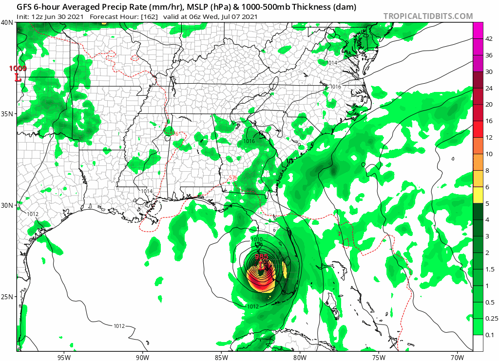
12Z coming in further east.
-
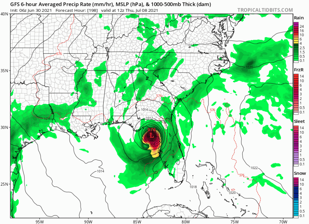
GFS with a cat 2 landfalling into northern Florida
-
2021 Atlantic Hurricane season
cptcatz replied to StormchaserChuck!'s topic in Tropical Headquarters
Models are in pretty good agreement that we'll have a tropical storm within 24 hours... -
2021 Atlantic Hurricane season
cptcatz replied to StormchaserChuck!'s topic in Tropical Headquarters
GFS is locked, loaded, and ready to go on 97L -
2021 Atlantic Hurricane season
cptcatz replied to StormchaserChuck!'s topic in Tropical Headquarters
This morning's HWRF develops 95L into a tiny cat 2 with the next wave hot on its heels... -
2021 Atlantic Hurricane season
cptcatz replied to StormchaserChuck!'s topic in Tropical Headquarters
00z Euro now backed off development altogether. Interesting how development COULD be within 24-48 hours and the models still can't figure it out. -
2021 Atlantic Hurricane season
cptcatz replied to StormchaserChuck!'s topic in Tropical Headquarters
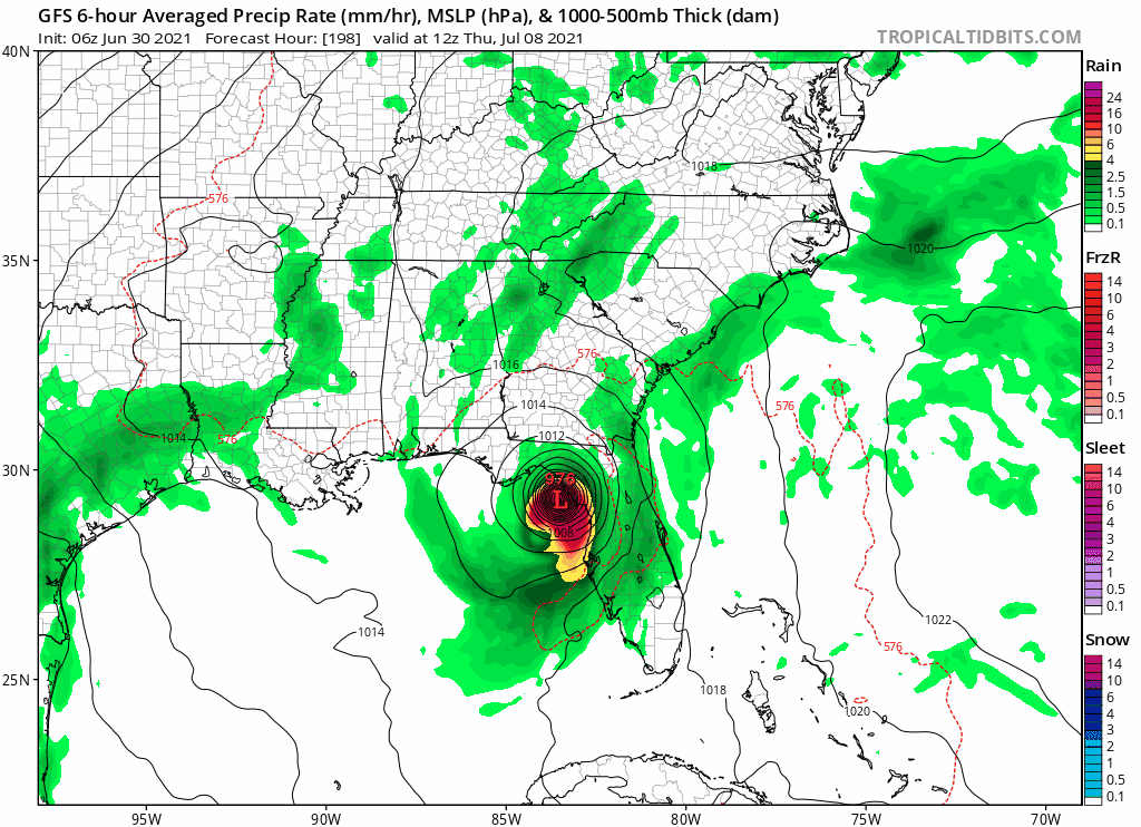
The windshield wiper effect is in full go mode with the 06z GFS back with a major hurricane into Texas. Regardless, we're at like 3 straight days of GFS runs showing this system forming so if doesn't that would be a huge flop. -
2021 Atlantic Hurricane season
cptcatz replied to StormchaserChuck!'s topic in Tropical Headquarters
This run has a 980 mb storm making a left turn into New England lol -
2021 Atlantic Hurricane season
cptcatz replied to StormchaserChuck!'s topic in Tropical Headquarters
Well that's interesting -
2021 Atlantic Hurricane season
cptcatz replied to StormchaserChuck!'s topic in Tropical Headquarters
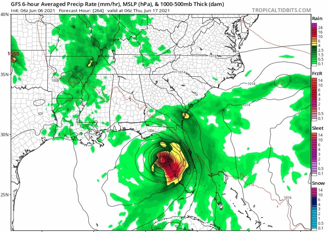
GFS-Euro-CMC all showing signs of our first CV storm developing next weekend with the GFS being most bullish tracking it all the way to the Caribbean... -
Seriously. Last summer a severe thunderstorm, typical of a South Florida summer thunderstorm was packing winds of 65+ mph, it knocked over my basketball hoop in the driveway which fell on my car denting the car and cracked the backboard. That was the worst weather damage I've had to deal with living in south Florida for the past 4 years. I'll always remember that nameless storm.
-
You can clearly see a tight lower level spin on the visible sat at 27.5N, 91.5W. I'd be surprised if NHC doesn't name it at 2pm.
-
2021 Atlantic Hurricane season
cptcatz replied to StormchaserChuck!'s topic in Tropical Headquarters
I don't know but the outflow of it provided a full day of much needed rain for us in south Florida. -
2021 Atlantic Hurricane season
cptcatz replied to StormchaserChuck!'s topic in Tropical Headquarters
If we're having fun with the random 14 day out models, the 18z GEFS shows a signal for another western Caribbean storm possibly heading towards your area... -
2021 Atlantic Hurricane season
cptcatz replied to StormchaserChuck!'s topic in Tropical Headquarters
Interesting GFS run this morning
-
2021 North Atlantic hurricane forecast contest
cptcatz replied to Roger Smith's topic in Tropical Headquarters
17/9/4 -
2021 Atlantic Hurricane season
cptcatz replied to StormchaserChuck!'s topic in Tropical Headquarters
Weird, because that seems to contradict this map -
2021 Atlantic Hurricane season
cptcatz replied to StormchaserChuck!'s topic in Tropical Headquarters
GFS has been pretty consistent with this homegrown system developing around June 10. This run also adds in a twin out in the Atlantic -
GFS dropped it. Looks like King Euro reigns supreme.
-
2021 North Atlantic hurricane forecast contest
cptcatz replied to Roger Smith's topic in Tropical Headquarters
10 majors? Bold. -
Test on whether the Euro will continue the trend of doing a terrible job at cyclogenesis: The GFS has been on this system for a while, shows a 939 mb storm south of Okinawa 240 hours out while Euro has squat. Who will win?
-
I was also looking for the Sally thread a while back and couldn't find it either, only the banter thread.
-
2021 Atlantic Hurricane season
cptcatz replied to StormchaserChuck!'s topic in Tropical Headquarters
The first GFS fantasyland tropical system of the 2021 Atlantic season! -
Katrina would like a word with you, sir.
-
2021 Atlantic Hurricane season
cptcatz replied to StormchaserChuck!'s topic in Tropical Headquarters
I'd love to know where you're getting your data from being that the models are not showing that... https://twitter.com/philklotzbach/status/1384171583023968259