

cptcatz
-
Posts
1,077 -
Joined
-
Last visited
Content Type
Profiles
Blogs
Forums
American Weather
Media Demo
Store
Gallery
Everything posted by cptcatz
-
2021 Atlantic Hurricane season
cptcatz replied to StormchaserChuck!'s topic in Tropical Headquarters
Interesting graphs being tweeted. This one shows the average ENSO for peak season is heading to a weak Nina: While this one shows a weak Nina producing the highest ACE: -
2021 Atlantic Hurricane season
cptcatz replied to StormchaserChuck!'s topic in Tropical Headquarters
TSR and CSU should be coming out with forecasts any day now. Anyone know when we can expect them? -
Lots of models now showing potential for something to spin up off the SE coast early next week...
-
Still looks like a strong La Nina though. Any news on if they think that will change?
-
Andrew was a cat 5 but I can't think of any other A-named cat 5's meaning that's the only season that opened with a cat 5. Has any other season other than 2020 ended with a cat 5?
-
With nothing showing on any global models now, it looks like the season may be a wrap. Quite a crazy season. I think the most impressive stat is out of the 13 hurricanes, 10 made landfall at or near maximum intensity.
-
Iota: "thanks, I'll take my beer back now"
-
Iota: "Hold my beer"
-
There's a pretty decent signal for another TC development next weekend. One ensemble member has a major going into Miami.
-
It would have to get over quite a ridge to make it up to the CONUS
-
January 1, 2021
-
Looking back on some earlier posts, it's pretty amazing that the GFS got the dip and stall near the Keys pretty spot on 10 days in advance, even if it was way too bullish on the intensity.
-
I'm not sure if it's just the westerly shear since we can't see the center but it sure looks like the convection blob is moving northeast and not north like the NHC indicated. I also second the recon question. It's a short flight from Lakeland and we can use some data. Wonder what they're waiting for.
-
You can't declare that until every last legal ACE number is counted. There are still storms to be tallied and the NHC hasn't certified the totals yet. Plus I could see 2020 not conceding until we get the post-season analysis updates. This can be a long drawn out battle...
-
98L classified in the eastern Caribbean. Could have three named storms in the next few days in mid-November.
-
It doesn't help that basically every model has it fizzling out before ever reaching land again. Feel like it's gonna be another Marco from here on out.
-
I just went into my bathroom and noticed water pooling on the floor, coming in from where the wall meets the floor. Ugh. Watching this next band closely on radar. As of now it looks like it may slide to the south of us but hard to tell with the curving movement.
-
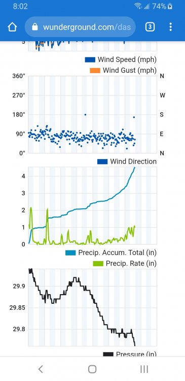
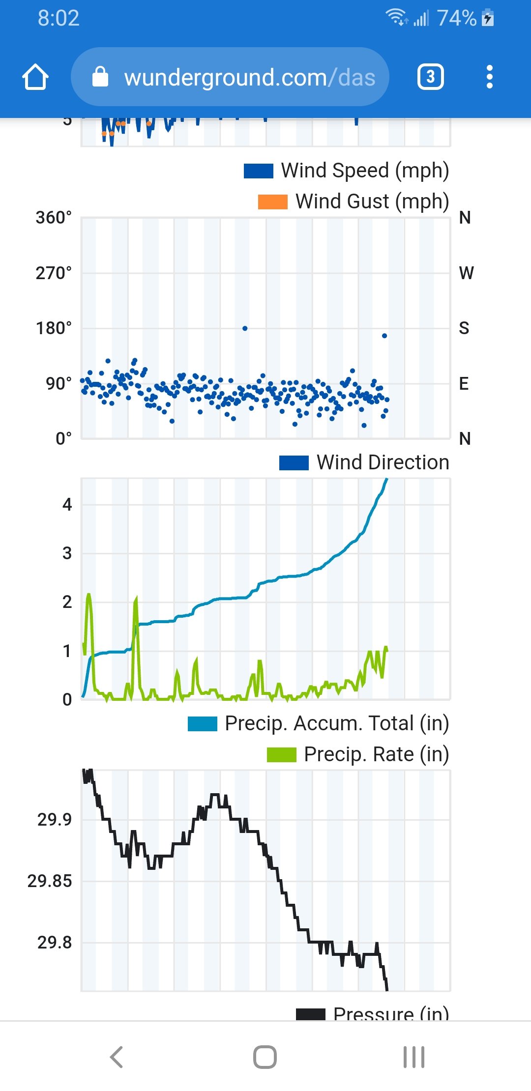
Just had an intense band move through Boca. Up to 4.62 inches of rain for the day and pressure is below 1008 mb.
-
Getting the strongest winds of the day now in Boca Raton (4.5 miles inland)
-
I got 1.56 inches yesterday and am up to 2.81 inches today. Not gonna get the 10-15 like some forecasts were calling but I can see getting another couple inches through midnight and then another one or two tomorrow on the backside, totaling 6-8 inches overall in three days.
-
Looks like some big convection popping up just offshore of Palm Beach County which should roll through my house soon.
-
Just took some video from my backyard in Boca Raton
-
I think we can officially say Cuba has INTENSIFIED every storm that crossed it in 2020. What a year!
-
70 kt wind just measured at flight level east of the eye
.thumb.png.61f3d12ab675df814007925d3fbacd26.png)
-
Recon just arrived into the storm, hopefully they stick around for a while so we can see the rate of intensification.


.png.fde247c7eab3317e9f5e01144c76f5a3.png)