cardinalland
-
Posts
516 -
Joined
-
Last visited
Content Type
Profiles
Blogs
Forums
American Weather
Media Demo
Store
Gallery
Everything posted by cardinalland
-
pouring in new haven with at least one lightning strike
-
on another note, here in dew haven we've finally hit that coveted 72 degree dewpoint.
-
lots of moderate 0.2" per hour rain moving into CT, the heavier stuff is staying over/just off the sound. hopefully this is light enough to not contribute to flooding... at least that was my experience with lighter rain during IDA
-
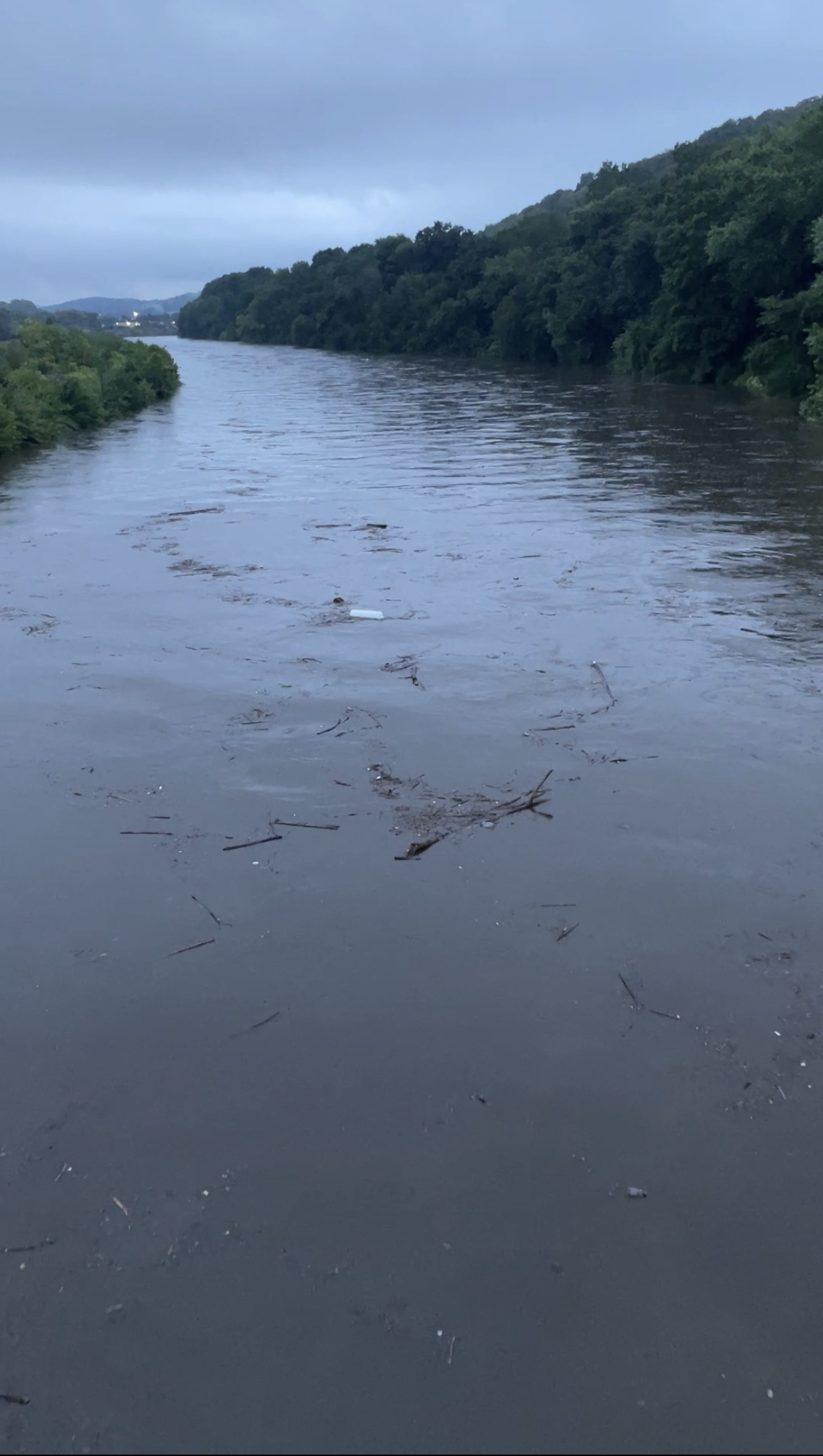
naugatuck river from bridge, derby ct, approx 7:15pm. wishing the best to all affected by this awful disaster.

-
i witnessed the housatonic/naugatuck confluence (derby) a couple hours ago. both rivers were raging and well above normal levels. the naugatuck rose 2-3 feet from 6:15pm to 7:15pm. i saw tires and trees floating, possibly a vehicle, along with other assorted detritus. thankfully derby is on very high ground and safe.
-
First spots are breaking 12" near the Housatonic River at Stevenson CT. Insanity
-
369 Oxford Rd, Oxford CT was the address mentioned
-
Lower Naugatuck Fire and EMS radio - reporting a bridge collapse over a stream in Oxford CT
-
that’s quite a feeder band over PR jeez
-
 the PNW is gonna be “chilly and wet” this winter? what??? unbelievable
 -
80/90 now. doesn’t seem to pose a threat to CONUS but NE Carib and bermuda should watch this one
-
these should be snow totals
-
downpour in the UWS. can’t see the other side of the hudson river due to visibility. lightning bolts going off
-
rumbling in manhattan upper west side. looks like we're in for a light show
-
lots of lightning here in harlem
-
just got out of twisters (the movie) and it’s ripping
-
Long Island Sound is great for swimming because the water is calm and warm. Hammonasset is good and there are a few other state beaches. No big waves though and many of the beaches are kinda small.
-
2024 Short/Medium Range Severe Weather Discussion
cardinalland replied to Chicago Storm's topic in Lakes/Ohio Valley
got a link for it? asking for a friend, thanks -
I wonder if we have higher potential today on a SSW/SW wind due to the drought southwest of here https://droughtmonitor.unl.edu/
-
2024 Atlantic Hurricane Season
cardinalland replied to Stormchaserchuck1's topic in Tropical Headquarters
Wind shear in the Caribbean should persist through most of the remainder of this month -
Looks just about due north to me in my radar imagery for the last 3 hours
-
C5 is possible in this region right now due to high ocean heat content. With that dropsonde it looks like Beryl is almost a C4 already. C5 is not out of the question in the next day or so

-
a useful link for more info on global warming and hurricanes from the GFDL: https://www.gfdl.noaa.gov/global-warming-and-hurricanes/#:~:text=Both the increased warming of,SSTs favor development and intensification.
-
I have my doubts as to if global warming will lead to a linear increase in hurricane count... Increases in upper tropospheric temperature may limit hurricanes just as much as increased ocean temperatures fuel them. There may be some crazy years though as things are thrown out of wack
-
2024 Atlantic Hurricane Season
cardinalland replied to Stormchaserchuck1's topic in Tropical Headquarters
Seeing likely 2-3 storms in one week in the Atlantic in June is impressive. I imagine we'll see a lull after as the current kelvin wave is leaving the area, and once the next kelvin wave comes around it's off to the races...