cardinalland
-
Posts
516 -
Joined
-
Last visited
Content Type
Profiles
Blogs
Forums
American Weather
Media Demo
Store
Gallery
Everything posted by cardinalland
-

December 2024 - Best look to an early December pattern in many a year!
cardinalland replied to FXWX's topic in New England
snow on a southwest wind... winters of yore... it will be 70 by christmas eve -
December 2024 - Best look to an early December pattern in many a year!
cardinalland replied to FXWX's topic in New England
i've had plenty of beer too but i can still recognize a -EPO -AO setup when i see one -
Turkey Day Birch Bender Snow Storm/Observation Thread 11/28/-11/29
cardinalland replied to dryslot's topic in New England
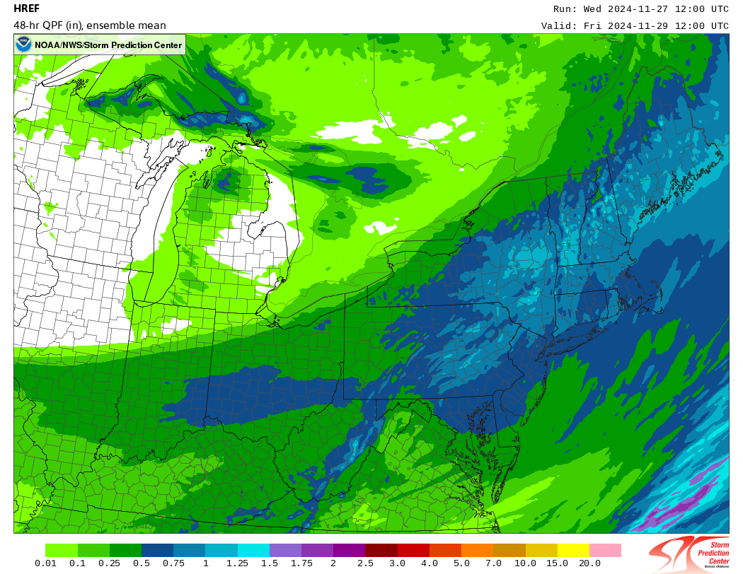
I don't think I've seen the HREF plumes yet. looking good for NNE mountains
-
December 2024 - Best look to an early December pattern in many a year!
cardinalland replied to FXWX's topic in New England
better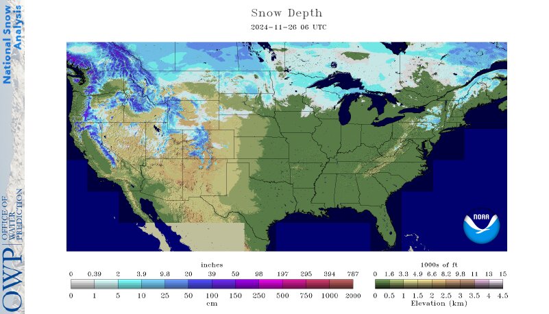
-
the MJO’s also just so far from here compared to other influences like EPO, NAO, pacific, atlantic, even el niño …
-
Blowvember - and not named for wind potential
cardinalland replied to Go Kart Mozart's topic in New England
True but I think we will struggle without at least some Eastern Canadian snow cover -
Blowvember - and not named for wind potential
cardinalland replied to Go Kart Mozart's topic in New England
i would also like to see this big patch of bare ground fill in before we really start talking snow to the coast. it's kinda ridiculous for late Nov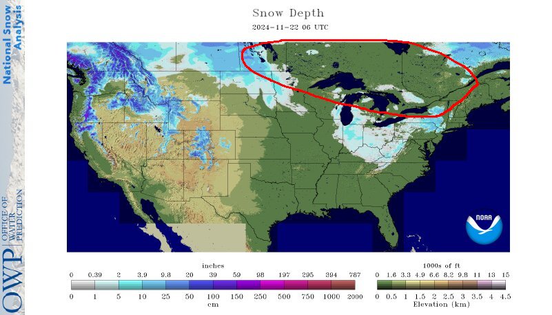
-
Blowvember - and not named for wind potential
cardinalland replied to Go Kart Mozart's topic in New England
the storm of interest around Tday has no antecedent cold airmass, so I don't see a pathway to big snow accums south of 90/495. It's an NNE event. But it looks like depending on how it evolves, it could push plenty of cold air into the area for the week after -
hmm my experience has been a little different... i feel like wrap around precipitation like this one has often panned out, but yep filling in on the back end (especially behind a frontal passage) is much rarer than models indicate
-
Blowvember - and not named for wind potential
cardinalland replied to Go Kart Mozart's topic in New England
just walked on the porch with a cold beer and said “we needed this” -
Does anyone know of a source of data for EPO forecasts that's updated daily? I can't believe it but I can't find anything for it on the web!
-
Blowvember - and not named for wind potential
cardinalland replied to Go Kart Mozart's topic in New England
i will definitely be standing on the porch watching the rain fall and saying "we needed this" -
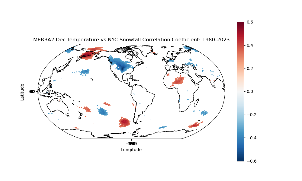
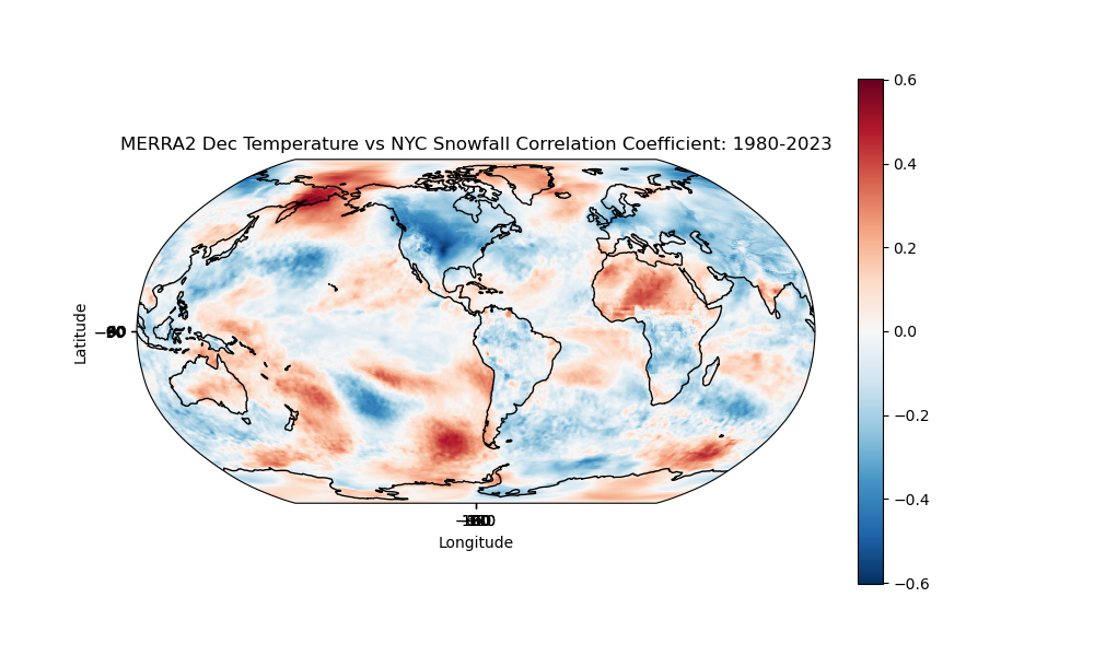
Decided to have some fun with data and correlated NYC snowfalls in December with temperatures around the world for the last 44 years. The first map only has statistically significant correlations and the second shows all. I guess a cold Plains and Midwest corresponds with higher snowfall around here. I probably didn't need to run the numbers to figure that out but here it is anyway. I was surprised by the western Canada correlation...
-
Blowvember - and not named for wind potential
cardinalland replied to Go Kart Mozart's topic in New England
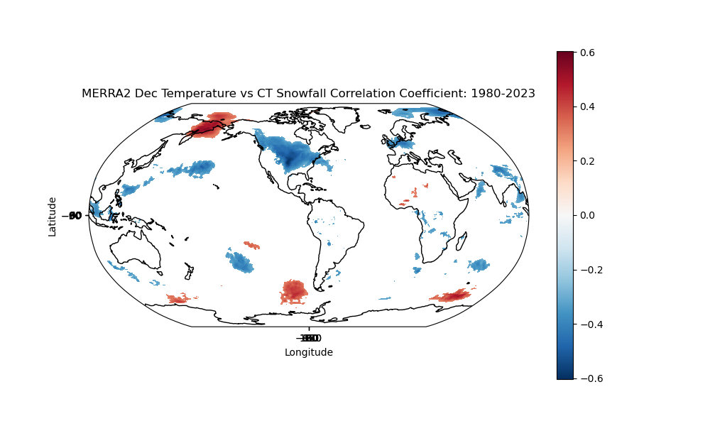
Decided to have some fun with data and correlated CT snowfalls in December with temperatures around the world for the last 44 years. It's CT but that maps well to SNE at least. The first map only has statistically significant correlations and the second shows all. I guess a cold Plains, Midwest, or northern US corresponds with higher snowfall around here. I probably didn't need to run the numbers to figure that out but here it is anyway.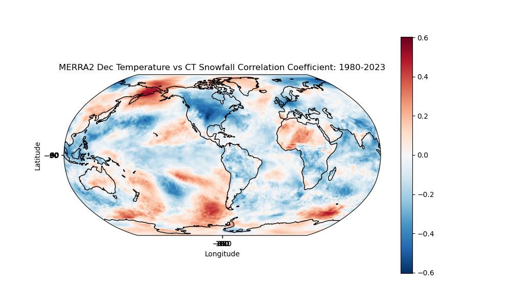
-
nice anticyclone and there’s some developing convection on satellite. i imagine after a TD forms in a day or 2, it’s off to the races unless it moves over land
-
geefus unleashes a monster… high potential here

-
Blowvember - and not named for wind potential
cardinalland replied to Go Kart Mozart's topic in New England
after March 10th we may have a shot of something in seriousness if a big cutter type system does end up developing, i imagine many of us in SNE will see first flakes from some cold pool snow showers -
yeah, these systems are interesting because they are sitting there in the gyre waiting for something to pull them out in some direction. Looks like most models have it going NW and then E right now, but I could also see a Central America landfall
-
2024 Atlantic Hurricane Season
cardinalland replied to Stormchaserchuck1's topic in Tropical Headquarters
If the Carib system becomes a hurricane, it will become the 12th in the Atlantic Hurricane Season. Only four other Atlantic seasons have seen this quantity of hurricanes on record: 2005 (15), 2020 (14), 1969 (12) and 2010 (12). -
2024 Atlantic Hurricane Season
cardinalland replied to Stormchaserchuck1's topic in Tropical Headquarters
This season has the 13th highest ACE since 1950 (so out of 75 seasons) which puts it in the top 20% in that period. To reach the top 10% it would have to attain an ACE of 182, which is unlikely but not impossible given the anticipated slow movement and high strength of this new system. Either way, we've experienced quite an active season. To reach top 10 in this period an ACE of 166 is needed, which is likely. -
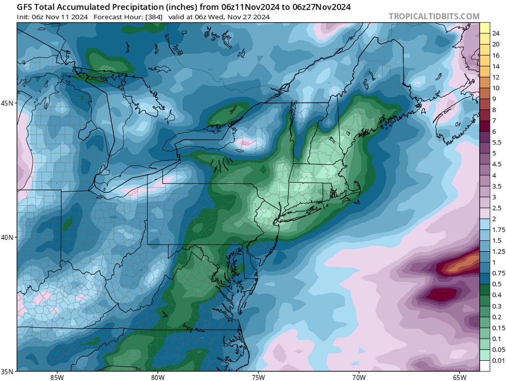
Blowvember - and not named for wind potential
cardinalland replied to Go Kart Mozart's topic in New England
this is getting absurd. and all of these include today’s rain event (except the GFS which includes like half of it)

-
Blowvember - and not named for wind potential
cardinalland replied to Go Kart Mozart's topic in New England
we froze here in new haven. i didn’t expect it this weekend but it happened! let the winter festivities begin -
i'm assuming the week before thanksgiving around 11/21? could see some kind of east coast storm action with a -NAO/-AO/neutral-ish PNA
-
this month, you could say San Diego! It's funny how almost every storm this month seems to be crossing our longitude at 50+N. We've gotten a cutter or two but I wonder when we'll get our first apps runner/coastal/clipper... anyways next couple weeks seem to be continuing with the "cuts so far it's off the map" theme
-
Blowvember - and not named for wind potential
cardinalland replied to Go Kart Mozart's topic in New England
down here in tropical new haven i’m still waiting on a first freeze. latest on record is 11/16 and beating that record looks like a lock