

George BM
-
Posts
2,906 -
Joined
-
Last visited
Content Type
Profiles
Blogs
Forums
American Weather
Media Demo
Store
Gallery
Everything posted by George BM
-
Some CAMs are actually somewhat bullish on some convective showers and, perhaps, a few thunderstorms tomorrow late afternoon/evening with the best thunderstorm chance east of I-95. These look like they may be slightly elevated but soundings look relatively favorable for some hail especially the further east you are. Low-level shear looks decent enough particularly in far eastern areas (near and east of the bay) where a surface low may form. So if the depth of the near-surface stable layer is shallow enough or if it's not very stout, there could be some brief low-level spin with a few of the storms that way.
-
IAD high of 67F.
-
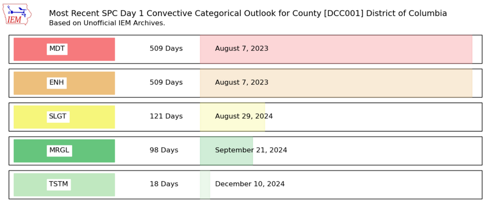
Unrelated- sorry for taking 5,000 years to respond ... the last time DC was under an ENH risk or greater was indeed not this year. It was August 7, 2023.
- 1,696 replies
-
- 3
-

-
- severe
- thunderstorms
- (and 5 more)
-
MBY Snow totals Winter 2024-2025 11/21/2024: T (A brief gusty rain/graupel shower around 6pm.) 11/22/2024: T (Flurries/light wet snow fell between 10am and 11:45am before mixing with and changing to light rain by 12:30pm.) 12/01/2024: T (Flurries off and on during the 4pm and 5pm hour.) 12/05/2024: T (Mixed light rain/snow between 4:30-5am w/ another brief light rain//snow mix between 7:30-7:40am.) 12/15/2024: T (A few ice pellets starting around 11:30am, then mixing with and changing to an off and on drizzle of rain/snow (intensified briefly into a light rain/snow mix during the 1pm hour). This lasted until after 3pm when precip again intensified into a light rain/snow mix before changing to all rain by 3:40pm.) 12/20/2024: T(A drizzle of rain/snow (8:30am-9am). A period of light snow between 10:30-11:15am, briefly approaching moderate intensity between 10:35am and 10:50am. Flurries continuing until midday. A few more flakes in the 6pm hour based on radar returns.) 12/24/2024: 0.1" (Light sleet started around 6:30am occasionally mixing with freezing rain through about 9am or so (more IP than ZR). Precip was very light but below freezing temps and a cold ground allowed for whitening of hard surfaces. Was originally going to call it a trace but with all of the 0.1" reports immediately surrounding me and taking into account sleet pellets piled at least two pellets high in depth... a tenth of an inch is the final measurement I went with making it the first measurable white stuff of the season for me.) Snow totals IMBY as of December 27, 2024: 0.1"
-
I hope all of you peeps had a VERY MERRY CHRISTMAS. …And a very Happy Hanukkah as well to those who celebrate!
-
Hard surfaces whitening with an orange/red southeastern sky.
-
Light IP/ZR here more IP than ZR.
-
Looks like a decent sunset is coming up based on the lack of clouds to the WSW of the clouds over the immediate region.
-
IAD got down to 14F.
-
Yeah. That NW to SE oriented band of clouds kept temps up in northern VA. IAD only bottomed out at 25F.
-
MBY Snow totals Winter 2024-2025 11/21/2024: T (A brief gusty rain/graupel shower around 6pm.) 11/22/2024: T (Flurries/light wet snow fell between 10am and 11:45am before mixing with and changing to light rain by 12:30pm.) 12/01/2024: T (Flurries off and on during the 4pm and 5pm hour.) 12/05/2024: T (Mixed light rain/snow between 4:30-5am w/ another brief light rain//snow mix between 7:30-7:40am.) 12/15/2024: T (A few ice pellets starting around 11:30am, then mixing with and changing to an off and on drizzle of rain/snow (intensified briefly into a light rain/snow mix during the 1pm hour). This lasted until after 3pm when precip again intensified into a light rain/snow mix before changing to all rain by 3:40pm.) 12/20/2024: T(A drizzle of rain/snow (8:30am-9am). A period of light snow between 10:30-11:15am, briefly approaching moderate intensity between 10:35am and 10:50am. Flurries continuing until midday. A few more flakes in the 6pm hour based on radar returns.) Snow totals IMBY as of December 21, 2024: T
-
Briefly moderate snow here. The aggregates were actually over 1/2" in diameter at one point. Still SN- atm. Herndon, VA.
-
MBY Snow totals Winter 2024-2025 11/21/2024: T (A brief gusty rain/graupel shower around 6pm.) 11/22/2024: T (Flurries/light wet snow fell between 10am and 11:45am before mixing with and changing to light rain by 12:30pm.) 12/01/2024: T (Flurries off and on during the 4pm and 5pm hour.) 12/05/2024: T (Mixed light rain/snow between 4:30-5am w/ another brief light rain//snow mix between 7:30-7:40am.) 12/15/2024: T (A few ice pellets starting around 11:30am, then mixing with and changing to an off and on drizzle of rain/snow (intensified briefly into a light rain/snow mix during the 1pm hour). This lasted until after 3pm when precip again intensified into a light rain/snow mix before changing to all rain by 3:40pm.) Snow totals IMBY as of December 16, 2024: T
-
12/15 Possible I81 event. First inch of the season out here?
George BM replied to clskinsfan's topic in Mid Atlantic
Ice pellets in Herndon. At least another trace. -
Five feet in NJ.
-
Lol it feels like a heatwave out there at 63F currently.
-
Looks like a good sunset is incoming.
-
*Nerd Post Alert* : Sunset in Baltimore is at 4:43pm from November 30th through December 13th. That would make Dec 6th and 7th the median dates meaning either the 6th or 7th features the earliest sunset. At Dulles Int'l Airport the earliest that the sun sets is at 4:47pm from December 1st through December 11th. That would make Dec 6th the median date. I'm getting the same median dates for the earliest sunset everywhere I look with the 6th winning over the 7th. Therefore, the absolute earliest sunset occurred today on the 6th. There will be a few more seconds (probably 1-3 seconds) of evening light tomorrow... not that anyone other than a super ultra weenie nerd like me would notice.
-
Todays sunset is the earliest one of the year. Starting tomorrow we gain evening light.
-
MBY Snow totals Winter 2024-2025 11/21/2024: T (A brief gusty rain/graupel shower around 6pm.) 11/22/2024: T (Flurries/light wet snow fell between 10am and 11:45am before mixing with and changing to light rain by 12:30pm.) 12/01/2024: T (Flurries off and on during the 4pm and 5pm hour.) 12/05/2024: T (Mixed light rain/snow between 4:30-5am w/ another brief light rain//snow mix between 7:30-7:40am.) Snow totals IMBY as of December 5, 2024: T
-
A mix of rain and snow here atm with this squall.
-
MBY Snow totals Winter 2024-2025 11/21/2024: T (A brief gusty rain/graupel shower around 6pm.) 11/22/2024: T (Flurries/light wet snow fell between 10am and 11:45am before mixing with and changing to light rain by 12:30pm.) 12/01/2024: T (Flurries off and on during the 4pm and 5pm hour.) Snow totals IMBY as of December 4, 2024: T
-
IAD got down to 19F.
-
Now I got flurries. A trace on the first day of Meteorological winter. Nice.
-
Welcome to Meteorological winter! A nice wintery start!


