

George BM
-
Posts
3,055 -
Joined
-
Last visited
Content Type
Profiles
Blogs
Forums
American Weather
Media Demo
Store
Gallery
Everything posted by George BM
-
MJJ 2025 ONI (rounded to nearest tenth): -0.1C MJJ 2025 RONI: -0.40C
-
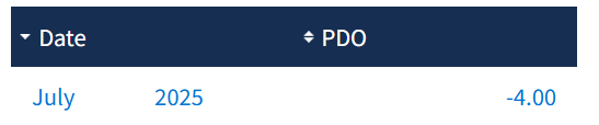
Fresh off the press. A new monthly record low for the PDO.
-
Friday, August 15, 2025 3:28PM EDT Okay. Here we go. Another record-breaking event. Thankfully this time this event will not result in us being thrown back into the stone age for weeks. This time we are looking at record breaking temperatures on the cold side w/ daytime highs well below our average lows for this time of year. A strong cold front moved through the region this morning bringing along a band of heavy gusty showers and embedded thunderstorms. Clear sunny skies have moved in across the region from the northwest on strong cold and dry air advection. As a result, although the sun is back out, temperatures have remained steady or even further fallen by a few degrees F into the upper 60s. Temps will fall more rapidly as we go into the evening hours with mid/upper 50s commonplace by sunset. Temps will plummet into the 40s overnight and bottom out in the lower 40s in the metros by dawn. The northwestern suburbs will likely be into the upper 30s challenging or breaking some all-time record lows for August. Meanwhile temps will fall below freezing in the mountains near the western edge of the forecast area where a Freeze Warning is in effect. With winds still elevated around 10-20 mph or so windchills will be in the mid/upper 30s in the metros and as low as 30F or even the upper 20s at times in the northwestern suburbs. Temperatures during the day on Saturday will only rebound to the upper 50s/ low 60s owing to continued cold-air advection. Those winds will die down Saturday night as the surface high settles in overhead. This will allow Sunday morning to feature the coldest temperatures since April with widespread monthly record lows. Temps will probably bottom out in the lower 40s again in the metros. But with decent radiational cooling conditions in place with the very dry airmass that will be in place, the suburbs may drop into the mid to perhaps low/mid 30s. Frost headlines will likely be needed for the northwestern suburbs on Sunday morning. Temps will rebound into the lower/mid 60s Sunday afternoon. During the week temps will rebound to closer to average with upper 70s/low 80s by midweek with a southerly flow to the east of a trough over the Ohio Valley potentially ushering in tropical trouble out of the south with Erin which some models and ensembles depicting frightening rain and wind scenarios which I’d rather not think about right now. Nope, I’m ending the discussion here.
-
A change of the month. A change in the airmass.
-
Bet the Pwats will be fun.
-
91/77 at IAD.
-
He's a harder case. His luck is very volatile. @EastCoast NPZ whatever you did during the month of May clearly worked out for you. Try that... at least to start.
-
@BlizzardNole If your vehicle has a sunroof, leave it open tomorrow. If you have a mower, leave it outside. And, of course, water everything tomorrow. Combine all that together and that should get you at least 3".
-
At one point overnight IAD was at 78/78! 78F w/ 100% humidity. Lol
-
@RaleighNC Your father was very influential on AmericanWx and had a great community here. I wish you lots of love, especially in this time, and may your father rest in peace.
-
96/73 at IAD.
-
Well guys and gals... it finally happened... I was mowing the lawn this morning when I saw it. My first lantern fly sighting. All red-eyed and looking straight at me while trembling. I tried stomping it but it was on the tall soft grass so it was fine. A minute later I see one again. I don't know whether it was the same one but it flew onto a small tree trunk just out of my reach. About 30-40 minutes later I'm out mowing the front yard (the first sightings were IMBY) when a third lantern flew onto the tree trunk next to me... it zipped out from under my shoe in the nick of time like in an action movie and flew into the grass a few clicks away. ... Yes... I could've just said that I saw three lantern flies today and left it at that but I'm more of a storyteller. ANYWAYS seeing that I'm in obs... currently 81/68 at IAD.
-
IAD got down to 64F.
-
Lol DCA always pissin' in the cheerios.
-
THIS. My body has acclimated to the tropics. Running outside on Tuesday morning is going to feel like eating Heaven's spaghetti.
-
Oof that really might as well be 111 for you. I know you're a cold guru. Dewpoints approaching the mid 70sF seem brutal especially considering your location.
-
Like...literally in your backyard? And yes... very electrical out there.
-
90/76 at IAD.
-
0.35" from yesterday evening
-
Yesterday mornings, yesterday evenings AND this mornings IAD soundings all showed 2.14" Pwats.
-
Currently 88/77 at IAD. Sauna.
-
Check out the July 8th update... lol
-
Since the daily index hit -2.00 nearly 3 weeks ago I've been waiting for a bounce up that, thus far, refuses to commence. It OBVIOUSLY will bounce back up a bit sooner rather than later but this has been impressive to track.
-
Yes. Definitely different from last summer so far which featured periods of higher temps but, overall, lower dewpoints when we were in the thick of the drought.
-
Cooler temps this morning, but there is a bit of a smoky haze at the surface from last night. Air quality is poor.


