George BM
-
Posts
3,048 -
Joined
-
Last visited
Content Type
Profiles
Blogs
Forums
American Weather
Media Demo
Store
Gallery
Everything posted by George BM
-
DCA: 100F IAD: 99F BWI: 101F RIC: 101F
-
17 years ago.

-
I didn't see this posted but the recent cool period had some cool stats (no pun intended).
-
Lol. I'm out of the summer touch at the moment. 84/62 is kicking my butt for some reason... probably due to the extended cool period. I'm screwed aren't I.
-
Third morning in a row that IAD gets down into the 40s. 47F for the low this AM.
-
IAD got down to 44F and 43F yesterday and today respectively.
-
Slightly older. One year until I enter the fourth decade on this sphere.
-
Welcome to Meteorological Summer and the brightest month of the year! Summer weather lovers rejoice. Cold weather lovers don't fret. Just three weeks until the days start getting shorter!
-
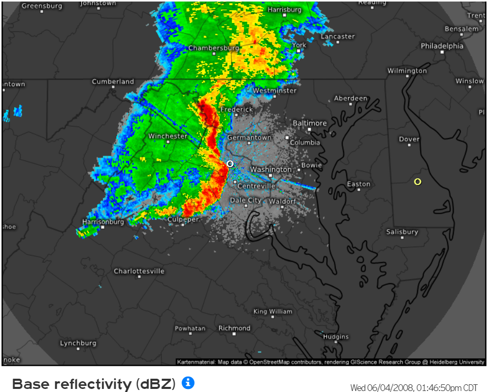
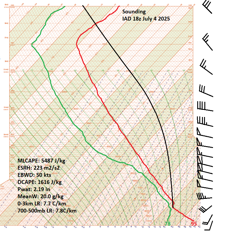
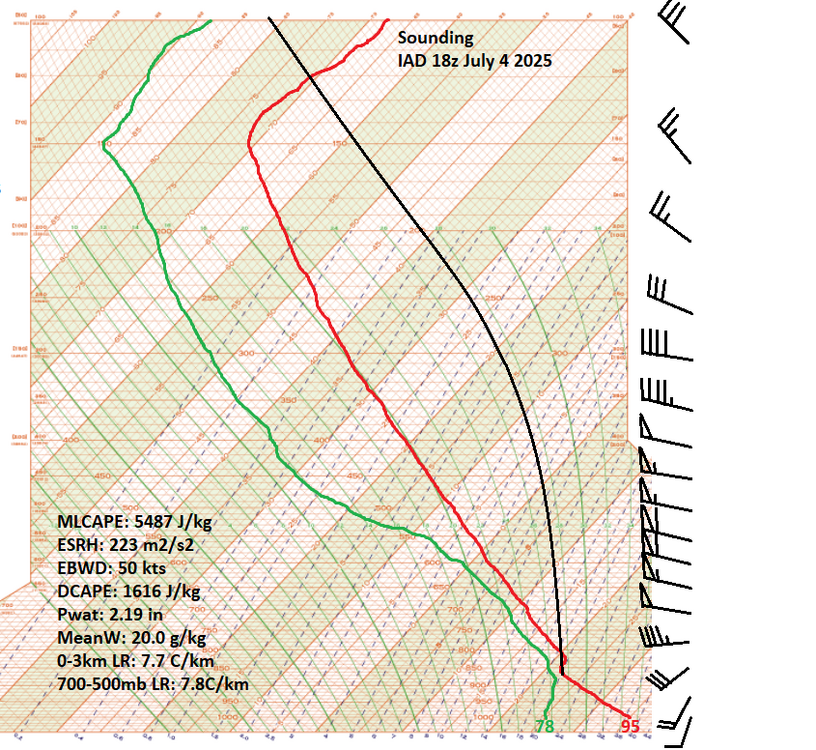
Baby Yoda: I mean it's no surprise when you see the kind of CAPE and shear that the 18z special sounding showed. Also from the latest meso discussion from SPC: "... A well-established cold pool and rear-inflow jet have accelerated the forward speed of the MCS to over 60kts. The extreme instability and moist airmass coupled with the large downdraft CAPE values will further increase the wind threat with corridors of 100+ mph wind gusts associated with embedded microbursts/macrobursts..." SnowingOverHere: Yeah. I better pack it up now. The tornado is probably embedded in that wall of rain that's protruding ahead of the main rain curtain. The greenage is unreal.

-
Correct! And thank you.
-
0.73" for the day. Up to 7.38" for the month of May.
-
I've finally reached the great egg.
-
Ha... I was wondering whether they meant to issue it until 6am TOMORROW morning and NOT Sunday morning as that would make more sense looking at the models. They've been very busy at the office this evening. URGENT - WEATHER MESSAGE National Weather Service Baltimore MD/Washington DC 920 PM EDT Fri May 30 2025 DCZ001-MDZ004>006-008-011-013-014-016>018-503>508-VAZ038>040-051-053- 054-501-502-505-506-526-527-310930- /O.EXT.KLWX.WI.Y.0016.250531T0400Z-250531T1000Z/ District of Columbia-Frederick MD-Carroll-Northern Baltimore- Cecil-Southern Baltimore-Prince Georges-Anne Arundel-Charles-St. Marys-Calvert-Northwest Montgomery-Central and Southeast Montgomery-Northwest Howard-Central and Southeast Howard- Northwest Harford-Southeast Harford-Greene-Madison-Rappahannock- Culpeper-Fairfax-Arlington/Falls Church/Alexandria-Northern Fauquier-Southern Fauquier-Western Loudoun-Eastern Loudoun- Northwest Prince William-Central and Southeast Prince William/Manassas/Manassas Park- 920 PM EDT Fri May 30 2025 ...WIND ADVISORY NOW IN EFFECT UNTIL 6 AM EDT SATURDAY... * WHAT...West winds 15 to 30 mph with gusts up to 50 mph. * WHERE...Portions of DC, central, north central, northeast, northern, and southern Maryland, and central, northern, and northwest Virginia. * WHEN...Until 6 AM EDT Saturday. * IMPACTS...Gusty winds will blow around unsecured objects. Tree limbs could be blown down and a few power outages may result. PRECAUTIONARY/PREPAREDNESS ACTIONS... Winds this strong can make driving difficult, especially for high profile vehicles. Use extra caution. Secure outdoor objects. && $$ DHOF
-
Wind Advisory now up from midnight tonight through early Sunday morning? URGENT - WEATHER MESSAGE National Weather Service Baltimore MD/Washington DC 840 PM EDT Fri May 30 2025 DCZ001-MDZ004>006-008-011-013-014-016>018-503>508-VAZ038>040-051-053- 054-501-502-505-506-526-527-310845- /O.NEW.KLWX.WI.Y.0016.250531T0400Z-250601T1000Z/ District of Columbia-Frederick MD-Carroll-Northern Baltimore- Cecil-Southern Baltimore-Prince Georges-Anne Arundel-Charles-St. Marys-Calvert-Northwest Montgomery-Central and Southeast Montgomery-Northwest Howard-Central and Southeast Howard- Northwest Harford-Southeast Harford-Greene-Madison-Rappahannock- Culpeper-Fairfax-Arlington/Falls Church/Alexandria-Northern Fauquier-Southern Fauquier-Western Loudoun-Eastern Loudoun- Northwest Prince William-Central and Southeast Prince William/Manassas/Manassas Park- 840 PM EDT Fri May 30 2025 ...WIND ADVISORY IN EFFECT FROM MIDNIGHT TONIGHT TO 6 AM EDT SUNDAY... * WHAT...West winds 15 to 30 mph with gusts up to 50 mph. * WHERE...DC, and portions of central, north central, northeast, northern, and southern Maryland, and central, northern, and northwest Virginia. * WHEN...From midnight tonight to 6 AM EDT Sunday. * IMPACTS...Gusty winds will blow around unsecured objects. Tree limbs could be blown down and a few power outages may result. PRECAUTIONARY/PREPAREDNESS ACTIONS... Winds this strong can make driving difficult, especially for high profile vehicles. Use extra caution. Secure outdoor objects. && $$ DHOF
-
Torrential rain I just received from this activity in Herndon.
-
MCD out for the immediate region. Mesoscale Discussion 1044 NWS Storm Prediction Center Norman OK 0249 PM CDT Fri May 30 2025 Areas affected...Parts of eastern VA...MD...DE...northeastern NC...and far southeastern PA Concerning...Severe potential...Watch likely Valid 301949Z - 302145Z Probability of Watch Issuance...80 percent SUMMARY...The risk of damaging wind gusts and a few tornadoes will increase in the 22Z-00Z time frame. A watch will likely be issued for parts of the area within an hour or two. DISCUSSION...Latest surface analysis shows a surface low over northern WV, with a quasi-warm front extending eastward across MD into southern NJ. Along/south of the front, diurnal heating within cloud breaks and lower/middle 60s dewpoints are contributing to around 1500 J/kg MLCAPE. As storms spread/develop eastward into the destabilizing air mass, 40-50 kt of effective shear should favor gradual intensification/organization into semi-discrete clusters and supercells. Enhanced clockwise hodograph curvature (around 150 m2/s2 effective SRH) ahead of the east-northeastward-moving surface low will support the potential for a few tornadoes (along with locally damaging wind gusts) with the more organized supercells that evolve. A watch is likely for parts of the area within an hour or two. ..Weinman/Smith.. 05/30/2025
- 1,378 replies
-
- 1
-

-
- severe
- thunderstorms
- (and 2 more)
-
Oh wow. I wasn't paying enough attention to the overnight wind threat. We'll see what happens. Definitely looks to be a windy system for the end of May. Surface low currently looks to be wrapping up a bit just south of the Kentucky, Ohio, West Virginia intersection.
-
Lol 13z HRRR is loltastically aggressive with a sting-jet feature overnight bringing 50-60mph wind gusts from northern VA through DC and southern MD... No I don't see it getting THAT windy.
-
T
- 1,378 replies
-
- 2
-
-

-
- severe
- thunderstorms
- (and 2 more)
-
Yeah. I know exactly which CAM prompted that reaction from you... just have the MCS track 60-75 miles further north and...........
-
2.21" since the night before last.
-
Yeah seems hard to believe it's been that long when you think about it. Since Jan 2024 there's seemingly been this invisible barrier preventing me from breaking 2" of rain during an event. I got close a couple of times with a couple of 1.8"+ events. I got 1.97" from Debby last year. But finally today the two-inch mark has been fully eclipsed.
-
I'm up to 2.04" here in Herndon, VA. Wettest event here in at least 16 months. 4.04" for the month of May so far.
-
1.30" for this event so far. Not bad.
-
0.67" thus far. 2.67" for May thus far. Strong reflectivities approaching from the southeast. (Herndon, VA)