George BM
-
Posts
3,048 -
Joined
-
Last visited
Content Type
Profiles
Blogs
Forums
American Weather
Media Demo
Store
Gallery
Everything posted by George BM
-
IAD got down to 34F.
-
I remember this day very well. One of a few times during my grade-school years when there was a thunderstorm during school hours (5th grade). The good stuff was to my east but there was heavy rain and occasional lightning and it was really dark blue outside.
-
Schumacher actually has much of the area in 15% for Sunday. https://schumacher.atmos.colostate.edu/hilla/csu_mlp/csu_severe.php?date=20251016&version=2021&day=4&product=severe_ml_day4_gefso&day_str=1020&init=00
- 1,378 replies
-
- 1
-

-
- severe
- thunderstorms
- (and 2 more)
-
@bigtenfan@Scott747 Title update?
-
Friday, October 31, 2025 8:31AM EDT Winter Storm Warning in effect from 3PM EDT this afternoon until midnight Saturday, November 1, 2025. Moderate to heavy rain continues to move through the region this morning with a few elevated thunderstorms towards central VA and southern MD. This activity will taper off to a few showers and drizzle by lunchtime. Temps all the while remaining unseasonably cold with upper 30s/ lower 40s commonplace. By the early afternoon our attention turns to the powerful and sharp shortwave trough approaching from the WSW providing ample lift for showers and elevated thunderstorms to move into and develop over the I-81 corridor. Mid-level temps will also cool as the shortwave moves in resulting in increased elevated instability with MUCAPE in excess of 250 J/kg possible. As we get into the mid-afternoon hours numerous bands of showers and elevated thunderstorms will overspread the region. The strongest storms could have small to medium sized hail (up to penny sized). As heights crash as the shortwave moves in strong dynamic cooling will take place resulting in rain changing over to a very heavy wet snow from west to east (most likely around 2pm along the 1-81 corridor. 3-5pm in the urban corridor and after 5pm east of I-95.) Snowfall rates will be very heavy in excess of 3-4 inches per hour (possibly 5”+/hr in the heaviest convective bands) w/ occasional lightning from convective elements continuing through the evening. Winds will gust upwards of 30 to 40 mph as the surface low rapidly deepens over the Delmarva peninsula resulting in near-zero visibility at times with the snow. Although this will be a quick hitting storm with snowfall tapering off everywhere before midnight the extreme snowfall rates will result in snowfall totals of 14 to 20 inches being commonplace throughout the majority of the forecast area with localized amounts approaching 24 inches possible. Snow drifts could exceed 4 feet. Furthermore, with the wet paste-like consistency of the snow expected, widespread tree damage and power outages are probable. Once snow tapers off skies will clear overnight with temperatures settling in the mid 20s to lower 30s. Temperatures will remain below average with 40s for highs and 20s for lows through the weekend and into next week. This is going to be a very high impact event that the area will feel the effects from for weeks to come. Please make sure you have a way to get electricity and stay up to date with the changing weather conditions.
-
Shorter days. Cooler nights. Increasing festiveness. Lowering humidity. Decreasing mosquitos.
-
Virginia Beach.
-
Joaquin of 2015 is the one for me.
-
1.13" for the event total here. Side note: The evening twenty-two years ago today was a gorgeous 10/10.
-
Happy Climatological Peak of Atlantic Hurricane Season Day!
-
IAD bottoming out at 47F.
-
0.03" here yesterday through early this morning.
-
Tuesday, September 16, 2025 Tornado Emergency remains in effect for northern Baltimore City and central Baltimore county until 5:45PM EDT. At 5:32PM a confirmed large and destructive tornado was located near Pikesville, MD moving northeast at 50 mph. Locations impacted include Pikesville, Stevenson, Brooklandville, Mays Chapel, Cockeysville, Hunt Valley, Ashland, Timonium, Phoenix, Jacksonville. This tornado has a history of producing catastrophic damage across parts of Montgomery and Howard counties in Maryland. This is a life-threatening situation. Everyone in the warned area must be underground in a basement until the storm passes.
-
Crisp unsummer-like weather continues. Happy Meteorological/Climatological Fall.
-
Looking forward to more cool, crisp mornings this week.
-
Not a flurry though.
-
1:51pm on an August 23rd. Thread bump time. Fourteen years ago at this moment was a fun time!
-
Flood Watch National Weather Service Baltimore MD/Washington DC 1157 AM EDT Wed Aug 13 2025 DCZ001-MDZ006-008-011-013-014-504-506>508-VAZ053-054-140000- /O.NEW.KLWX.FA.A.0032.250813T1800Z-250814T0100Z/ /00000.0.ER.000000T0000Z.000000T0000Z.000000T0000Z.OO/ District of Columbia-Northern Baltimore-Cecil-Southern Baltimore- Prince Georges-Anne Arundel-Central and Southeast Montgomery- Central and Southeast Howard-Northwest Harford-Southeast Harford- Fairfax-Arlington/Falls Church/Alexandria- 1157 AM EDT Wed Aug 13 2025 ...FLOOD WATCH IN EFFECT UNTIL 9 PM EDT THIS EVENING... * WHAT...Flash flooding caused by excessive rainfall is possible. * WHERE...Portions of DC, including the following , District of Columbia, Maryland, including the following areas, Anne Arundel, Cecil, Central and Southeast Howard, Central and Southeast Montgomery, Northern Baltimore, Northwest Harford, Prince Georges, Southeast Harford and Southern Baltimore, and northern Virginia, including the following areas, Arlington/Falls Church/Alexandria and Fairfax. * WHEN...Until 9 PM EDT this evening. * IMPACTS...Excessive runoff may result in flooding of rivers, creeks, streams, and other low-lying and flood-prone locations. Flooding may occur in poor drainage and urban areas. * ADDITIONAL DETAILS... - Thunderstorms are likely this afternoon into this evening with heavy rainfall within a short period of time. Localized rainfall amounts around 1 to 2 inches within an hour are likely. Multiple rounds of storms are possible with total rainfall amounts around 2 to 4 inches. This may cause creeks and small streams to rise out of their banks with flash flooding possible. - Please visit www.weather.gov/safety/flood for flood safety and preparedness information PRECAUTIONARY/PREPAREDNESS ACTIONS... You should monitor later forecasts and be prepared to take action should Flash Flood Warnings be issued. && $$ AVS
-
MJJ 2025 ONI (rounded to nearest tenth): -0.1C MJJ 2025 RONI: -0.40C
-
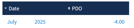
Fresh off the press. A new monthly record low for the PDO.
-
Friday, August 15, 2025 3:28PM EDT Okay. Here we go. Another record-breaking event. Thankfully this time this event will not result in us being thrown back into the stone age for weeks. This time we are looking at record breaking temperatures on the cold side w/ daytime highs well below our average lows for this time of year. A strong cold front moved through the region this morning bringing along a band of heavy gusty showers and embedded thunderstorms. Clear sunny skies have moved in across the region from the northwest on strong cold and dry air advection. As a result, although the sun is back out, temperatures have remained steady or even further fallen by a few degrees F into the upper 60s. Temps will fall more rapidly as we go into the evening hours with mid/upper 50s commonplace by sunset. Temps will plummet into the 40s overnight and bottom out in the lower 40s in the metros by dawn. The northwestern suburbs will likely be into the upper 30s challenging or breaking some all-time record lows for August. Meanwhile temps will fall below freezing in the mountains near the western edge of the forecast area where a Freeze Warning is in effect. With winds still elevated around 10-20 mph or so windchills will be in the mid/upper 30s in the metros and as low as 30F or even the upper 20s at times in the northwestern suburbs. Temperatures during the day on Saturday will only rebound to the upper 50s/ low 60s owing to continued cold-air advection. Those winds will die down Saturday night as the surface high settles in overhead. This will allow Sunday morning to feature the coldest temperatures since April with widespread monthly record lows. Temps will probably bottom out in the lower 40s again in the metros. But with decent radiational cooling conditions in place with the very dry airmass that will be in place, the suburbs may drop into the mid to perhaps low/mid 30s. Frost headlines will likely be needed for the northwestern suburbs on Sunday morning. Temps will rebound into the lower/mid 60s Sunday afternoon. During the week temps will rebound to closer to average with upper 70s/low 80s by midweek with a southerly flow to the east of a trough over the Ohio Valley potentially ushering in tropical trouble out of the south with Erin which some models and ensembles depicting frightening rain and wind scenarios which I’d rather not think about right now. Nope, I’m ending the discussion here.
-
A change of the month. A change in the airmass.
-
Bet the Pwats will be fun.
-
91/77 at IAD.
-
He's a harder case. His luck is very volatile. @EastCoast NPZ whatever you did during the month of May clearly worked out for you. Try that... at least to start.