George BM
-
Posts
3,048 -
Joined
-
Last visited
Content Type
Profiles
Blogs
Forums
American Weather
Media Demo
Store
Gallery
Everything posted by George BM
-
MBY Snow totals Winter 2024-2025 11/21/2024: T (A brief gusty rain/graupel shower around 6pm.) 11/22/2024: T (Flurries/light wet snow fell between 10am and 11:45am before mixing with and changing to light rain by 12:30pm.) 12/01/2024: T (Flurries off and on during the 4pm and 5pm hour.) 12/05/2024: T (Mixed light rain/snow between 4:30-5am w/ another brief light rain//snow mix between 7:30-7:40am.) 12/15/2024: T (A few ice pellets starting around 11:30am, then mixing with and changing to an off and on drizzle of rain/snow (intensified briefly into a light rain/snow mix during the 1pm hour). This lasted until after 3pm when precip again intensified into a light rain/snow mix before changing to all rain by 3:40pm.) 12/20/2024: T(A drizzle of rain/snow (8:30am-9am). A period of light snow between 10:30-11:15am, briefly approaching moderate intensity between 10:35am and 10:50am. Flurries continuing until midday. A few more flakes in the 6pm hour based on radar returns.) 12/24/2024: 0.1" (Light sleet started around 6:30am occasionally mixing with freezing rain through about 9am or so (more IP than ZR). Precip was very light but below freezing temps and a cold ground allowed for whitening of hard surfaces. Was originally going to call it a trace but with all of the 0.1" reports immediately surrounding me and taking into account sleet pellets piled at least two pellets high in depth... a tenth of an inch is the final measurement I went with making it the first measurable white stuff of the season for me.) 1/03/2025: 0.2" (Brief light rain/snow/graupel shower around 2pm. Heavy snow associated with a developing snow squall between 2:50pm-3:15pm with a brief brake in intensity to light snow between 3:00pm and 3:05pm. A second snow squall from 4:13pm to 4:25pm. Snow was light to moderate with the second squall until 4:22pm when rates briefly became as heavy as during first squall. Peak snowfall rates from both squalls in the 1-2"/hr range.) 1/06/2025: 6.2" (First flakes around or shortly after midnight on the 6th. Light snow becoming moderate at times by 2:00am lasting through 7am before becoming intermittent and tapering off to a few small flakes/crystals by 9:45am. A brief moderate snow shower around 1:40pm tapering off to a light snow then flurries by 2:20pm and holding near that intensity until the 4pm hour when it became a very light snowfall again. Light snow, approaching moderate intensity at times from the 5pm hour through 8:30pm, then very light snow/flurries until 10:15pm when snow tapered off.) 1/10-11/2025: 1.7" (Flurries/light snow starting in the 10pm hour intensifying to light/moderate snow 10:50-10:55pm. Snow became moderate to even mod/heavy at times with peak snowfall rates of 1"+/hr at times between 11pm and 12:45am. Snow then became occasional and light until the mid-overnight hours when it ended.) Snow totals IMBY as of January 11, 2025: 8.2"
-
Got down to 22F this morning at IAD post-storm.
-
MBY Snow totals Winter 2024-2025 11/21/2024: T (A brief gusty rain/graupel shower around 6pm.) 11/22/2024: T (Flurries/light wet snow fell between 10am and 11:45am before mixing with and changing to light rain by 12:30pm.) 12/01/2024: T (Flurries off and on during the 4pm and 5pm hour.) 12/05/2024: T (Mixed light rain/snow between 4:30-5am w/ another brief light rain//snow mix between 7:30-7:40am.) 12/15/2024: T (A few ice pellets starting around 11:30am, then mixing with and changing to an off and on drizzle of rain/snow (intensified briefly into a light rain/snow mix during the 1pm hour). This lasted until after 3pm when precip again intensified into a light rain/snow mix before changing to all rain by 3:40pm.) 12/20/2024: T(A drizzle of rain/snow (8:30am-9am). A period of light snow between 10:30-11:15am, briefly approaching moderate intensity between 10:35am and 10:50am. Flurries continuing until midday. A few more flakes in the 6pm hour based on radar returns.) 12/24/2024: 0.1" (Light sleet started around 6:30am occasionally mixing with freezing rain through about 9am or so (more IP than ZR). Precip was very light but below freezing temps and a cold ground allowed for whitening of hard surfaces. Was originally going to call it a trace but with all of the 0.1" reports immediately surrounding me and taking into account sleet pellets piled at least two pellets high in depth... a tenth of an inch is the final measurement I went with making it the first measurable white stuff of the season for me.) 1/03/2025: 0.2" (Brief light rain/snow/graupel shower around 2pm. Heavy snow associated with a developing snow squall between 2:50pm-3:15pm with a brief brake in intensity to light snow between 3:00pm and 3:05pm. A second snow squall from 4:13pm to 4:25pm. Snow was light to moderate with the second squall until 4:22pm when rates briefly became as heavy as during first squall. Peak snowfall rates from both squalls in the 1-2"/hr range.) 1/06/2025: 6.2" (First flakes around or shortly after midnight on the 6th. Light snow becoming moderate at times by 2:00am lasting through 7am before becoming intermittent and tapering off to a few small flakes/crystals by 9:45am. A brief moderate snow shower around 1:40pm tapering off to a light snow then flurries by 2:20pm and holding near that intensity until the 4pm hour when it became a very light snowfall again. Light snow, approaching moderate intensity at times from the 5pm hour through 8:30pm, then very light snow/flurries until 10:15pm when snow tapered off.) Snow totals IMBY as of January 6, 2025: 6.5"
-
MBY Snow totals Winter 2024-2025 11/21/2024: T (A brief gusty rain/graupel shower around 6pm.) 11/22/2024: T (Flurries/light wet snow fell between 10am and 11:45am before mixing with and changing to light rain by 12:30pm.) 12/01/2024: T (Flurries off and on during the 4pm and 5pm hour.) 12/05/2024: T (Mixed light rain/snow between 4:30-5am w/ another brief light rain//snow mix between 7:30-7:40am.) 12/15/2024: T (A few ice pellets starting around 11:30am, then mixing with and changing to an off and on drizzle of rain/snow (intensified briefly into a light rain/snow mix during the 1pm hour). This lasted until after 3pm when precip again intensified into a light rain/snow mix before changing to all rain by 3:40pm.) 12/20/2024: T(A drizzle of rain/snow (8:30am-9am). A period of light snow between 10:30-11:15am, briefly approaching moderate intensity between 10:35am and 10:50am. Flurries continuing until midday. A few more flakes in the 6pm hour based on radar returns.) 12/24/2024: 0.1" (Light sleet started around 6:30am occasionally mixing with freezing rain through about 9am or so (more IP than ZR). Precip was very light but below freezing temps and a cold ground allowed for whitening of hard surfaces. Was originally going to call it a trace but with all of the 0.1" reports immediately surrounding me and taking into account sleet pellets piled at least two pellets high in depth... a tenth of an inch is the final measurement I went with making it the first measurable white stuff of the season for me.) 1/03/2025: 0.2" (Brief light rain/snow/graupel shower around 2pm. Heavy snow associated with a developing snow squall between 2:50pm-3:15pm with a brief brief in intensity to light snow between 3:00pm and 3:05pm. A second snow squall from 4:13pm to 4:25pm. Snow was light to moderate with the second squall until 4:22pm when rates briefly became as heavy as during first squall. Peak snowfall rates from both squalls in the 1-2"/hr range.) Snow totals IMBY as of January 4, 2025: 0.3"
-
Lol! Second time the Monument gets struck this week.
- 616 replies
-
- 15
-

-

-

-

-
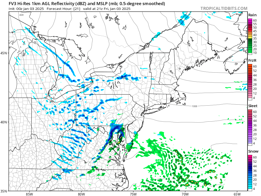
Wondering if those 50+ DBZ reflectivities near Fairfax are all snow or some kind of mix.
-
Rain/snow mix here in Herndon.
-
Some CAMs have >100 J/kg of CAPE with some positive CAPE reaching above 600mb where the temp drops to near -30C. So I wouldn't be surprised if there were a few lightning events with the most intense snow showers/squalls.
-
Gnarly squall on the FV3.

-
I don't hate the steep low/mid-level lapse rates and non-zero CAPE for Friday afternoon on the 12z 3kmNAM and FV3. Good conditions for some locally intense snow showers/squalls.
-
A chilly and windy day to start the year following rain and thunderstorms the prior day.
-
Happy New Year of 2025! Let it be a year full of rewards and taking great care of yourselves. And may we have many exciting weather events to weenie over!
-
Happy New Year!
-
Yeah. Just had a fairly hefty bolt not too far away a few minutes ago. (Herndon, VA)
-
Some CAMs are actually somewhat bullish on some convective showers and, perhaps, a few thunderstorms tomorrow late afternoon/evening with the best thunderstorm chance east of I-95. These look like they may be slightly elevated but soundings look relatively favorable for some hail especially the further east you are. Low-level shear looks decent enough particularly in far eastern areas (near and east of the bay) where a surface low may form. So if the depth of the near-surface stable layer is shallow enough or if it's not very stout, there could be some brief low-level spin with a few of the storms that way.
-
IAD high of 67F.
-
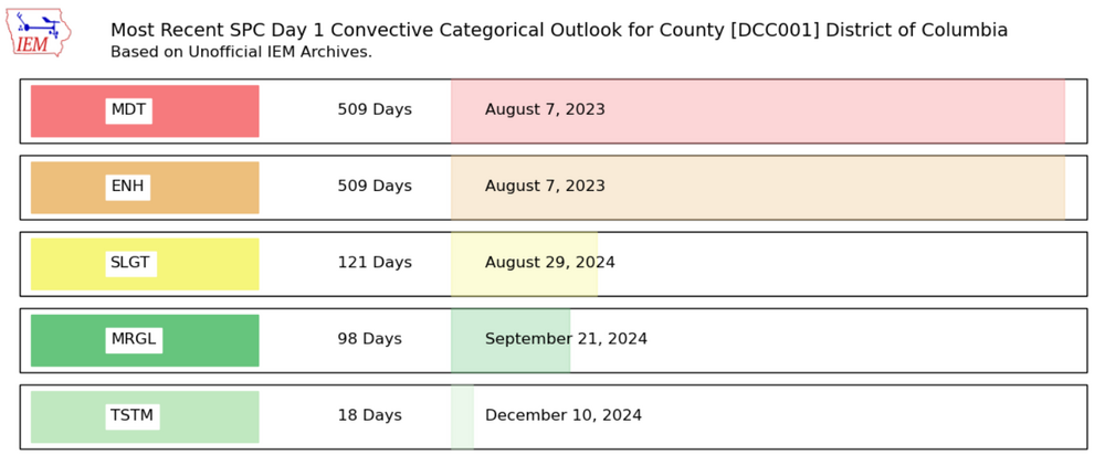
Unrelated- sorry for taking 5,000 years to respond ... the last time DC was under an ENH risk or greater was indeed not this year. It was August 7, 2023.
- 1,696 replies
-
- 3
-
-
- severe
- thunderstorms
- (and 5 more)
-
MBY Snow totals Winter 2024-2025 11/21/2024: T (A brief gusty rain/graupel shower around 6pm.) 11/22/2024: T (Flurries/light wet snow fell between 10am and 11:45am before mixing with and changing to light rain by 12:30pm.) 12/01/2024: T (Flurries off and on during the 4pm and 5pm hour.) 12/05/2024: T (Mixed light rain/snow between 4:30-5am w/ another brief light rain//snow mix between 7:30-7:40am.) 12/15/2024: T (A few ice pellets starting around 11:30am, then mixing with and changing to an off and on drizzle of rain/snow (intensified briefly into a light rain/snow mix during the 1pm hour). This lasted until after 3pm when precip again intensified into a light rain/snow mix before changing to all rain by 3:40pm.) 12/20/2024: T(A drizzle of rain/snow (8:30am-9am). A period of light snow between 10:30-11:15am, briefly approaching moderate intensity between 10:35am and 10:50am. Flurries continuing until midday. A few more flakes in the 6pm hour based on radar returns.) 12/24/2024: 0.1" (Light sleet started around 6:30am occasionally mixing with freezing rain through about 9am or so (more IP than ZR). Precip was very light but below freezing temps and a cold ground allowed for whitening of hard surfaces. Was originally going to call it a trace but with all of the 0.1" reports immediately surrounding me and taking into account sleet pellets piled at least two pellets high in depth... a tenth of an inch is the final measurement I went with making it the first measurable white stuff of the season for me.) Snow totals IMBY as of December 27, 2024: 0.1"
-
I hope all of you peeps had a VERY MERRY CHRISTMAS. …And a very Happy Hanukkah as well to those who celebrate!
-
Hard surfaces whitening with an orange/red southeastern sky.
-
Light IP/ZR here more IP than ZR.
-
Looks like a decent sunset is coming up based on the lack of clouds to the WSW of the clouds over the immediate region.
-
IAD got down to 14F.
-
Yeah. That NW to SE oriented band of clouds kept temps up in northern VA. IAD only bottomed out at 25F.
-
MBY Snow totals Winter 2024-2025 11/21/2024: T (A brief gusty rain/graupel shower around 6pm.) 11/22/2024: T (Flurries/light wet snow fell between 10am and 11:45am before mixing with and changing to light rain by 12:30pm.) 12/01/2024: T (Flurries off and on during the 4pm and 5pm hour.) 12/05/2024: T (Mixed light rain/snow between 4:30-5am w/ another brief light rain//snow mix between 7:30-7:40am.) 12/15/2024: T (A few ice pellets starting around 11:30am, then mixing with and changing to an off and on drizzle of rain/snow (intensified briefly into a light rain/snow mix during the 1pm hour). This lasted until after 3pm when precip again intensified into a light rain/snow mix before changing to all rain by 3:40pm.) 12/20/2024: T(A drizzle of rain/snow (8:30am-9am). A period of light snow between 10:30-11:15am, briefly approaching moderate intensity between 10:35am and 10:50am. Flurries continuing until midday. A few more flakes in the 6pm hour based on radar returns.) Snow totals IMBY as of December 21, 2024: T