George BM
Members-
Posts
3,010 -
Joined
-
Last visited
Content Type
Profiles
Blogs
Forums
American Weather
Media Demo
Store
Gallery
Everything posted by George BM
-
Minus the rain, this has been an epic stretch of weather for you.
-
Random question @Mrs.J. Have you ever thought of or do you plan on opening your own restaurant?
-
What is the difference between a 30-min IPA, a 60-min IPA, a 90-min IPA and a 120-min IPA? Do they each have their own effects/taste?
-
Peanut Butter/Chocolate Protein Bars.
-
2020 Mid-Atlantic Severe Weather - General Thread
George BM replied to Kmlwx's topic in Mid Atlantic
That's what pulled my arm enough for me to make the post about Sundays potential. -
2020 Mid-Atlantic Severe Weather - General Thread
George BM replied to Kmlwx's topic in Mid Atlantic
For the past several days I've been low-key watching the Sunday system for any severe potential and as of right now late Sunday has slight potential to get interesting should we have enough CAPE (which currently looks modest to perhaps locally moderate with LI of -3 to -5). Deep layer flow looks fairly strong (on the order of 50+ kts in the mid-levels). Should we be able to get enough sunshine for more moderate CAPE it could get interesting for some. Timing does look to be leaning a bit on the later side ATM. Then there is also still the question of how far north this 'threat' will extend. #Notanexpertopinion #Justmy2cents -
2020 Mid-Atlantic Severe Weather - General Thread
George BM replied to Kmlwx's topic in Mid Atlantic
While just about all ensembles have this trough staying over the eastern US for the remainder of the month into the beginning May I wonder if we can get into some W/NW flow action sometime early in May (2nd week?) as the trough slowly lifts and/or shifts eastward (as shown in a number of long range ens. ATM). Just speculation at this point of course... and me thinking out loud. -
2020 Mid-Atlantic Severe Weather - General Thread
George BM replied to Kmlwx's topic in Mid Atlantic
A pretty decent gust-front just went through Charles Town looking at the radar. What would you guesstimate the strength of the gusts to be? -
2020 Mid-Atlantic Severe Weather - General Thread
George BM replied to Kmlwx's topic in Mid Atlantic
The DC metro is now within the SLGT risk. 0% Tornado/ 15% Wind/ 0% Hail -
2020 Mid-Atlantic Severe Weather - General Thread
George BM replied to Kmlwx's topic in Mid Atlantic
Don't completely sleep on this Tuesday either. There could be some low-topped convection with limited CAPE along and just ahead of the cold front. Steep low-level lapse rates and fairly fast-flow aloft could translate to some of the convection having strong wind gusts. -
2020 Mid-Atlantic Severe Weather - General Thread
George BM replied to Kmlwx's topic in Mid Atlantic
This shows that we at least have a non-zero severe chance through the end of April. -
2020 Mid-Atlantic Severe Weather - General Thread
George BM replied to Kmlwx's topic in Mid Atlantic
Even the April 6, 2017 had fairly widespread strong winds and seven EF-0 tornadoes in northern VA... this with less than 250J/kg MUCAPE. That June 13, 2013 event could have been a memorable event area-wide if the morning MCS didn't hamper things. It was also the last time we had a moderate risk in the immediate region though it was downgraded to a SLGT at 1630z due to said morning MCS leaving us with AOB 1000 J/Kg MLCAPE. This is my opinion (not an expert): When dealing with a W/NW flow event with a fairly strong low-pressure system within the flow there will very often be a morning/early day MCS. This is because the previous days storms that develop in the Midwest often grow upscale during the evening and are able to survive the whole night due to the better dynamics and CAPE. With the forward speed that these MCSs usually have they very often reach us during the morning hours. An ideal thing with these regimes would be either the timing being a few hours faster so that we can get more midday/solar noon sunshine to destabilize the atmosphere more quickly for any later day activity (easier option) or a heat-dome already being in place so that any morning event would stay to the north while the low-pressure system approaches from the W/NW spawning another MCS (or just decent storms in general) during the afternoon to cruise through the region during the afternoon/evening (harder to pull off option). -
2020 Mid-Atlantic Severe Weather - General Thread
George BM replied to Kmlwx's topic in Mid Atlantic
Thank you both for the replies. -
2020 Mid-Atlantic Severe Weather - General Thread
George BM replied to Kmlwx's topic in Mid Atlantic
Sorry for the novice question but how do I read this? Is this showing the expected surface wind speed and direction at various times? -
2020 Mid-Atlantic Severe Weather - General Thread
George BM replied to Kmlwx's topic in Mid Atlantic
Mesoscale Discussion 0360 NWS Storm Prediction Center Norman OK 0426 PM CDT Sun Apr 12 2020 Areas affected...south-central and southeast Mississippi Concerning...Tornado Watch 106...107... Valid 122126Z - 122200Z The severe weather threat for Tornado Watch 106, 107 continues. SUMMARY...Based on recent radar and environmental data, a violent tornado with potential peak winds of 170 to 205 mph (EF4-EF5) is likely ongoing. THIS IS AN EXCEPTIONALLY RARE EVENT. DISCUSSION...An intense supercell will continue to move through a favorable environment over south-central Mississippi, characterized by 0-1 km SRH around 400 m2/s2 and MLCAPE near 2000 J/kg per latest mesoanalysis data. Recent radar signatures from KLIX as of 2112Z reveal an intense supercell characterized by a 0.4 degree rotational velocity of at least 70 kt. A tornadic debris signature has also been noted on recent radar scans. These signatures are occurring in an environment characterized by STP greater than 7. Previous signatures within similar environments produced tornado-damage-estimated wind speeds from 170 to 205 mph and confidence is high for a likely violent tornado. A long-track tornado is expected to continue based on the rotational velocity duration and the storm moving within a favorable downstream environment. -
2020 Mid-Atlantic Severe Weather - General Thread
George BM replied to Kmlwx's topic in Mid Atlantic
Also RAP'd. -
2020 Mid-Atlantic Severe Weather - General Thread
George BM replied to Kmlwx's topic in Mid Atlantic
I know that the post-frontal winds may be strong but... though we are not expecting much of this atm pre-cold front can you imagine if we somehow got a break in the clouds late tomorrow morning with those kind of low-level winds overhead?... Of course this is more speculative than me predicting it. -
2020 Mid-Atlantic Severe Weather - General Thread
George BM replied to Kmlwx's topic in Mid Atlantic
Even the long-range 6z hrrr (Yes, all caveats apply... end of range) shows 45-50 kt post-frontal gusts across the region. I usually find the hrrr more in line with what happens during synoptic wind events during the daylight hours. All long-range caveats aside... it looks windy tomorrow. -
2020 Mid-Atlantic Severe Weather - General Thread
George BM replied to Kmlwx's topic in Mid Atlantic
A rare Day 3 update. Day 3 Convective Outlook AMEND 1 NWS Storm Prediction Center Norman OK 0211 PM CDT Sat Apr 11 2020 ...Virginia through central and eastern Pennsylvania and New Jersey... Have expanded the SLGT risk farther north into this region. Areas of rain and thunderstorms will likely be ongoing north of a warm front from PA and NJ into southern New England. This activity will shift northeast during the morning allowing modest destabilization to occur in the pre-frontal warm sector with MLCAPE from 400-800 J/kg. Storms are expected to redevelop along cold front and in association with deeper forcing accompanying the northeast-ejecting shortwave trough. Wind profiles with 50+ kt effective bulk shear along with large 0-1 km hodographs will promote a threat for organized storms including supercells capable of damaging wind and a couple of tornadoes. -
2020 Mid-Atlantic Severe Weather - General Thread
George BM replied to Kmlwx's topic in Mid Atlantic
Psssst.... June 23rd is around the block. -
2020 Mid-Atlantic Severe Weather - General Thread
George BM replied to Kmlwx's topic in Mid Atlantic
The "obviously overdone severe-weenie" 6z 3kNAM said we get a supercell through DC tomorrow afternoon. -
2020 Mid-Atlantic Severe Weather - General Thread
George BM replied to Kmlwx's topic in Mid Atlantic
A pre-climo NW flow regime w/ potentially steep mid-level lapse rates... We watch. -
2020 Mid-Atlantic Severe Weather - General Thread
George BM replied to Kmlwx's topic in Mid Atlantic
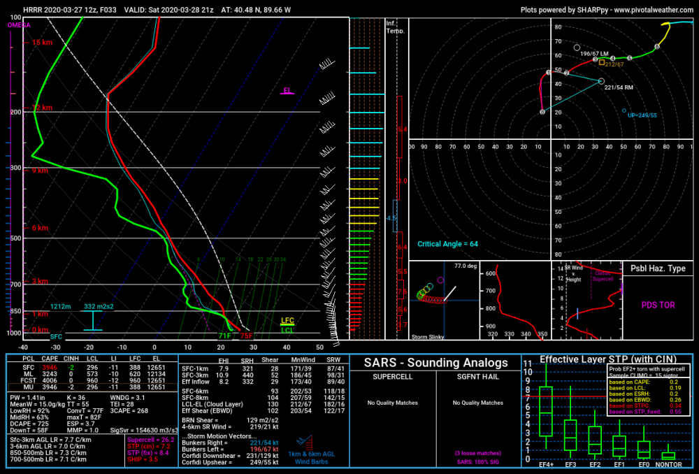
Thank for the reply. Yeah the latest long-range HRRR has some loltastic soundings. I mean check out this uncontaminated sounding below. I mean 3,000+ J/kg MLCAPE, LI near -10 with effective bulk-shear around 100kts. Lol! -
2020 Mid-Atlantic Severe Weather - General Thread
George BM replied to Kmlwx's topic in Mid Atlantic
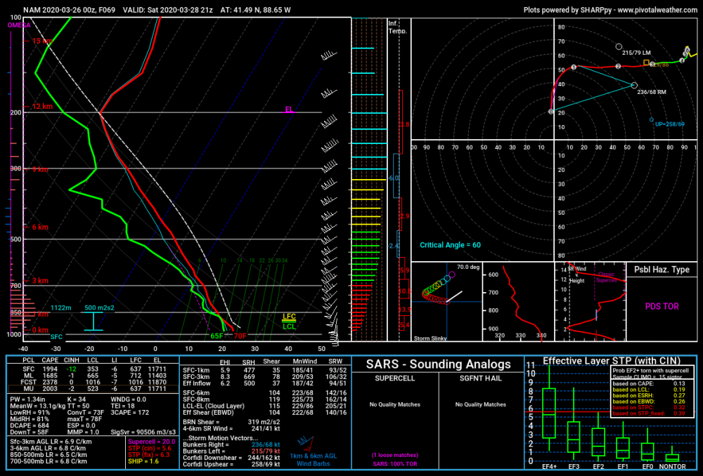
Now this is not for our region (SW of Chicago)... AND it's just one run from last night's 0z NAM at range but... it's not too often that you see 100+ knot EBWD with 1,000+ J/kg MLCAPE. (Also, please ignore the fact that I accidentally called these files as the 3kNAM... the images below are actually from the lower-res NAM) The following is just me thinking out loud. I'm not making assumptions about the severe threat over yonder. I wonder if 1,500+ J/kg mlcape and LIs of -5 to -6 would be enough instability for storms to not get ripped apart by this kind of shear verbatim (Is CAPE fat enough?). Yeah 1,500 J/kg mlcape is not all that weak but... that shear though... Of course I'm not trying to take away from the high-ceiling that storms will have should they take advantage of their environment. @high risk @csnavywx thoughts on this? Also I realize now that I have a problem with using too many ellipses and parentheses.


