

George BM
-
Posts
3,048 -
Joined
-
Last visited
Content Type
Profiles
Blogs
Forums
American Weather
Media Demo
Store
Gallery
Everything posted by George BM
-
2020 Mid-Atlantic Severe Weather - General Thread
George BM replied to Kmlwx's topic in Mid Atlantic
Indeed. Now parts of the upper Ohio Valley into the Great Lakes region are under a moderate risk of severe weather (45% hatched wind)... only the second moderate risk or greater anywhere in the US since April. -
2020 Mid-Atlantic Severe Weather - General Thread
George BM replied to Kmlwx's topic in Mid Atlantic
Lots of models have been hinting at a strong shortwave trough interacting with Cristobal's remnant circulation and becoming negatively-tilted through the Ohio Valley. The GFS has been most aggressive and fastest model when it comes to swinging the cold front associated with the shortwave through the region (late Wednesday). Most other models are slower with the cold front and have weaker shear/dynamics as a result of the shortwave being farther away from us by the time the front passes through (Wednesday night/ early Thursday) as well as poor timing heating-wise anyway. Should the shortwave and front be a bit faster, like the GFS shows, there could be a severe threat come later Wednesday given the warm/moist airmass that should be in place from Cristobal. Just me thinking out loud. It's a bit of a long shot atm given how different the GFS is from other models timing-wise. Well have to see how the interaction takes place between the two main features. #Notanexpertopinion -
2020 Mid-Atlantic Severe Weather - General Thread
George BM replied to Kmlwx's topic in Mid Atlantic
Being in a spot that normally misses out on storms this evenings storm was a decent one my MBY standards. Sheets of rain w/ 40+ mph wind gusts at times. Better than normal for MBY. -
2020 Mid-Atlantic Severe Weather - General Thread
George BM replied to Kmlwx's topic in Mid Atlantic
https://www.earthcam.com/usa/newjersey/seasideheights/?cam=seasideheights Next in line. -
2020 Mid-Atlantic Severe Weather - General Thread
George BM replied to Kmlwx's topic in Mid Atlantic
Yeap. I haven't noticed any lightning though. -
2020 Mid-Atlantic Severe Weather - General Thread
George BM replied to Kmlwx's topic in Mid Atlantic
https://www.earthcam.com/usa/pennsylvania/philadelphia/?cam=philly Enjoy. -
2020 Mid-Atlantic Severe Weather - General Thread
George BM replied to Kmlwx's topic in Mid Atlantic
Verbatim, it would be a nice fast-moving line with good wind potential if CAPE ended up better than modeled... not that I'm implying that it will be. -
2020 Mid-Atlantic Severe Weather - General Thread
George BM replied to Kmlwx's topic in Mid Atlantic
-
Many thanks to you all for the birthday wishes, Weather family!
-
2020 Mid-Atlantic Severe Weather - General Thread
George BM replied to Kmlwx's topic in Mid Atlantic
Congrats intermountain NW?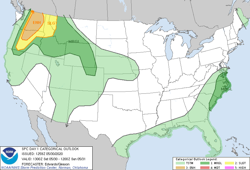
-
2020 Mid-Atlantic Severe Weather - General Thread
George BM replied to Kmlwx's topic in Mid Atlantic
I'm just glad that I was not old enough (4 years old) to remember that debacle of an 'event'. -
2020 Mid-Atlantic Severe Weather - General Thread
George BM replied to Kmlwx's topic in Mid Atlantic
Yeap. URGENT - IMMEDIATE BROADCAST REQUESTED SEVERE THUNDERSTORM WATCH NUMBER 666 STORM PREDICTION CENTER NORMAN OK 1219 PM EDT WED AUG 9 2000 THE STORM PREDICTION CENTER HAS ISSUED A SEVERE THUNDERSTORM WATCH FOR PORTIONS OF DISTRICT OF COLUMBIA MARYLAND SOUTHERN PENNSYLVANIA NORTHERN VIRGINIA CENTRASL AND EASTERN WEST VIRGINIA EFFECTIVE THIS WEDNESDAY AFTERNOON AND EVENING FROM 100 PM UNTIL 700 PM EDT. ...THIS IS A PARTICULARLY DANGEROUS SITUATION... DESTRUCTIVE WINDS. ALSO...HAIL TO 1 INCH IN DIAMETER... THUNDERSTORM WIND GUSTS TO 95 MPH...AND DANGEROUS LIGHTNING ARE POSSIBLE IN THESE AREAS. THE SEVERE THUNDERSTORM WATCH AREA IS ALONG AND 70 STATUTE MILES NORTH AND SOUTH OF A LINE FROM 60 MILES WEST SOUTHWEST OF MORGANTOWN WEST VIRGINIA TO 10 MILES EAST SOUTHEAST OF BALTIMORE MARYLAND. REMEMBER...A SEVERE THUNDERSTORM WATCH MEANS CONDITIONS ARE FAVORABLE FOR SEVERE THUNDERSTORMS IN AND CLOSE TO THE WATCH AREA. PERSONS IN THESE AREAS SHOULD BE ON THE LOOKOUT FOR THREATENING WEATHER CONDITIONS AND LISTEN FOR LATER STATEMENTS AND POSSIBLE WARNINGS. OTHER WATCH INFORMATION... CONTINUE...WW 665... DISCUSSION...INTENSE BOW ECHO OVER SERN OHIO IS EXPECTED TO CONTINUE EWD AT 55 KT ACROSS THE APPALACHIANS WITH WIDESPREAD DAMAGING WINDS LIKELY. ACTIIVTY WILL REACH THE BALTIMORE/WASHINGTON DC AREA AROUND 5 PM. AVIATION...A FEW SEVERE THUNDERSTORMS WITH HAIL SURFACE AND ALOFT TO 1 INCH EXTREME TURBULENCE AND SURFACE WIND GUSTS TO 80 KNOTS. A FEW CUMULONIMBI WITH MAXIMUM TOPS TO 500. MEAN STORM MOTION VECTOR 27055. -
2020 Mid-Atlantic Severe Weather - General Thread
George BM replied to Kmlwx's topic in Mid Atlantic
August. August 9, 2000 to be exact. It was even Severe Thunderstorm Watch 666. Lol. -
2020 Mid-Atlantic Severe Weather - General Thread
George BM replied to Kmlwx's topic in Mid Atlantic
For todays risk look out for how much high level cloud cover we get from the storms currently developing in the Carolinas. -
2020 Mid-Atlantic Severe Weather - General Thread
George BM replied to Kmlwx's topic in Mid Atlantic
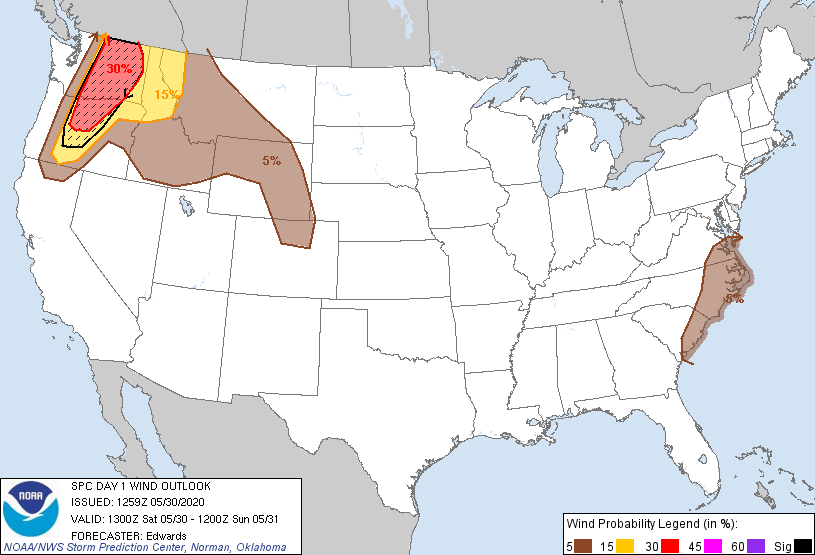
There hasn't been a MOD or HIGH risk issued anywhere in the country this month from SPC. Quiet indeed. One time period that I'll watch is following the cool shot at the beginning of next week. As a ridge tries to build in during the week watch for any potential NW-flow event. Small note: Some of the 0z convective models hint at scattered storms/convection trying to develop tomorrow afternoon from Bertha. There looks like there will be some low-level shear (not super impressive LLshear but some LLshear). If storms can develop tomorrow there might be a risk of gusty winds and perhaps a rotating meso or two. #Notanexpertopinion -
I just got a new Honda HRN216VKA self-propelled push mower (a durable mower) after the Toro that we had since 2003 finally gave up the ghost last month if this adds anything of value for you.
-
@H2O Happy 49ing!...Or is it 50ing? I'm pretty sure it's forty-nining IIRC.
-
Is this a future storm in the GOM this year? Also, do we get some decent remnants from it up here?
-
I should probably start checking myself for ticks from time to time... especially considering that I occasionally walk/hike/run through tall grass and weeds in my local park (I like going through the wilderness off the paved surfaces).
-
But was it good though?
-
I've never drank once in my life before.
-
Minus the rain, this has been an epic stretch of weather for you.
-
Random question @Mrs.J. Have you ever thought of or do you plan on opening your own restaurant?
-
What is the difference between a 30-min IPA, a 60-min IPA, a 90-min IPA and a 120-min IPA? Do they each have their own effects/taste?
-
Peanut Butter/Chocolate Protein Bars.

