George BM
-
Posts
3,048 -
Joined
-
Last visited
Content Type
Profiles
Blogs
Forums
American Weather
Media Demo
Store
Gallery
Everything posted by George BM
-
Tropical Storm Debby: Mid-Atlantic Impacts
George BM replied to WxWatcher007's topic in Mid Atlantic
Exactly 1" here since last night. (Herndon, VA) Up to 2.15" for August. -
I'd say so.
.thumb.gif.971befc80c217862a66630447801e21c.gif)
-
Now IAD was at 101F for one minute just now.
-
IAD was at 100F for one minute a short time ago.
-
IAD has hit 99F thus far.
-
Assuming the smoke aloft over the Ohio Valley west of the Appalachian mountains doesn't block out too much sunlight a fairly decent sunset could be coming up.
-
About 0.13" here (Herndon, VA). Roughly 2.20-2.25" for July so far.
-
Could be a nice looking storm-cloud base over Springfield atm.
-
A thin line of clouds have been over northern VA and generally over my house since before sunrise. https://weather.cod.edu/satrad/?parms=subregional-Virginias-02-96-1-25-1&checked=map&colorbar=undefined
-
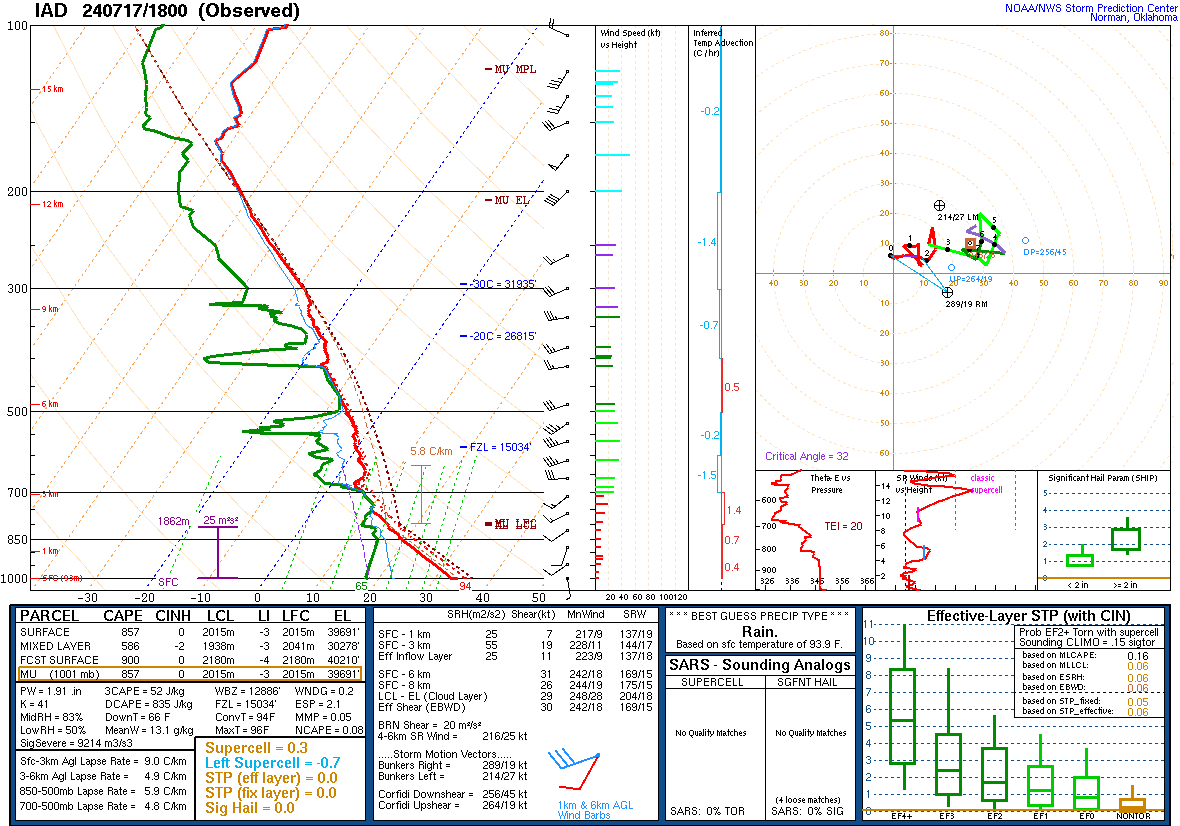
18z IAD sounding. Steep LLLRs and fairly high Pwats... though weak MLLRs. Could be some decent downburst/outflow winds should storms mature locally.
- 1,696 replies
-
- 2
-

-
- severe
- thunderstorms
- (and 5 more)
-
It's an MCV from a storm complex that died over Kentucky pre-dawn this morning. And, yeah, it'll be interesting the see whether it can fire up a batch of storms locally later. Storms are already forming under the vortmax.
-
Yeap. Everything Kmlwx said. That's my go to link for weather obs at IAD.
-
IAD has hit 101F. First time since 2012.
-
3pm obs: DCA: 103F BWI: 103F IAD: 100F
-
Looks like DCA has hit 104F! Wow.
-
IAD finally joins the triple-digit party at 100F.
-
BWI with a one-O-two.
-
1pm obs: DCA: 101F BWI: 100F IAD: 97F
-
Already 100F at BWI.
-
12pm obs: BWI: 99F DCA: 96F IAD: 96F
-
BWI has hit 102F.
-
3pm obs: DCA: 101F (New daily record) BWI: 100F IAD: 97F
-
BWI has also hit 100F.
-
DCA has hit 100F. IAD has hit 99F so far. BWI at least 99F.
-
Got about 0.35" or so here. (Herndon, VA) That's 0.55" for July so far.
.gif.cfc4dfdc29bc15e517eab88b6e104ea2.gif)