George BM
-
Posts
3,048 -
Joined
-
Last visited
Content Type
Profiles
Blogs
Forums
American Weather
Media Demo
Store
Gallery
Everything posted by George BM
-
Unsurprisingly, a heat advisory is now up for tomorrow as well. IAD has hit 96F so far.
-
Also, the record warm daily minimum temp for June at IAD is 74F. It got down to 75F this morning and with storms/convection looking very unlikely...
-
IAD already at 95F with a 67F dewpoint. Here we come.
-
IAD has already hit 90F.
-
IAD only got down to 75F this morning. Time to June 2012 it up in here.
-
IAD has topped out at 97F thus far.
-
IAD at 95/63.
-
Currently 93/65 at IAD. Hottest temp of the year so far.
-
Heat Advisory for the entire area tomorrow. URGENT - WEATHER MESSAGE National Weather Service Baltimore MD/Washington DC 1235 PM EDT Fri Jun 21 2024 DCZ001-MDZ003>006-008-011-013-014-016>018-501>508-VAZ027>031- 037>040-050-051-053>057-501-502-505-506-526-527-WVZ050>053-055- 502>504-220045- /O.CON.KLWX.HT.Y.0002.240622T1500Z-240623T0000Z/ District of Columbia-Washington-Frederick MD-Carroll- Northern Baltimore-Cecil-Southern Baltimore-Prince Georges- Anne Arundel-Charles-St. Marys-Calvert-Extreme Western Allegany- Central and Eastern Allegany-Northwest Montgomery- Central and Southeast Montgomery-Northwest Howard- Central and Southeast Howard-Northwest Harford-Southeast Harford- Shenandoah-Frederick VA-Page-Warren-Clarke-Albemarle-Greene- Madison-Rappahannock-Orange-Culpeper-Fairfax- Arlington/Falls Church/Alexandria-Stafford-Spotsylvania- King George-Northern Fauquier-Southern Fauquier-Western Loudoun- Eastern Loudoun-Northwest Prince William- Central and Southeast Prince William/Manassas/Manassas Park- Hampshire-Morgan-Berkeley-Jefferson-Hardy-Eastern Grant- Western Mineral-Eastern Mineral- Including the cities of Washington, Hagerstown, Frederick, Ballenger Creek, Eldersburg, Westminster, Reisterstown, Cockeysville, Elkton, Baltimore, Bowie, Suitland-Silver Hill, Clinton, College Park, Greenbelt, Laurel, Camp Springs, Glen Burnie, Annapolis, Severn, South Gate, Severna Park, Arnold, Odenton, St. Charles, Waldorf, Lexington Park, California, Chesapeake Beach, Huntingtown, Dunkirk, North Beach, Lusby, Prince Frederick, Frostburg, Cumberland, Germantown, Damascus, Bethesda, Rockville, Gaithersburg, Silver Spring, Lisbon, Columbia, Ellicott City, Jarrettsville, Aberdeen, Strasburg, Woodstock, Mount Jackson, New Market, Winchester, Luray, Shenandoah, Stanley, Front Royal, Berryville, Charlottesville, Stanardsville, Madison, Orange, Gordonsville, Culpeper, Reston, Herndon, Annandale, Centreville, Chantilly, McLean, Franconia, Arlington, Alexandria, Falls Church, Falmouth, Fredericksburg, Dahlgren, Warrenton, Turnbull, Purcellville, Leesburg, Ashburn, Sterling, Haymarket, Dale City, Manassas, Woodbridge, Lake Ridge, Montclair, Romney, Paw Paw, Martinsburg, Charles Town, Shepherdstown, Moorefield, Petersburg, Elk Garden, Antioch, Keyser, New Creek, Ridgeville, Russelldale, Headsville, and Fort Ashby 1235 PM EDT Fri Jun 21 2024 ...HEAT ADVISORY REMAINS IN EFFECT FROM 11 AM TO 8 PM EDT SATURDAY... * WHAT...Heat index values up to around 105 to 107 expected, with heat index values generally between 100 and 104 degrees west of the Blue Ridge Mountains. * WHERE...Portions of central, north central, northeast, northern, southern and western Maryland, The District of Columbia, central, northern and northwest Virginia and eastern and panhandle West Virginia. * WHEN...From 11 AM to 8 PM EDT Saturday. * IMPACTS...Hot temperatures and high humidity may cause heat illnesses to occur. * ADDITIONAL DETAILS...Oppressive heat and humidity will overspread the area Saturday and last into Sunday. Little relief from the heat is expected Saturday night with low temperatures in mid 70s to near 80 for most, which will compound heat stress on those without air conditioning. PRECAUTIONARY/PREPAREDNESS ACTIONS... Drink plenty of fluids, stay in an air-conditioned room, stay out of the sun, and check up on relatives and neighbors. Young children and pets should never be left unattended in vehicles under any circumstances. Take extra precautions if you work or spend time outside. When possible reschedule strenuous activities to early morning or evening. Know the signs and symptoms of heat exhaustion and heat stroke. Wear lightweight and loose fitting clothing when possible. To reduce risk during outdoor work, the Occupational Safety and Health Administration recommends scheduling frequent rest breaks in shaded or air conditioned environments. Anyone overcome by heat should be moved to a cool and shaded location. Heat stroke is an emergency! Call 9 1 1. && $$
-
URGENT - WEATHER MESSAGE National Weather Service Baltimore MD/Washington DC 459 PM EDT Thu Jun 20 2024 DCZ001-MDZ004>006-008-011-013-014-016-503>508-VAZ037>040-050-051- 053>057-501-502-505-506-526-527-210500- /O.NEW.KLWX.EH.A.0003.240622T1600Z-240623T0000Z/ District of Columbia-Frederick MD-Carroll-Northern Baltimore- Cecil-Southern Baltimore-Prince Georges-Anne Arundel-Charles- Northwest Montgomery-Central and Southeast Montgomery-Northwest Howard-Central and Southeast Howard-Northwest Harford-Southeast Harford-Albemarle-Greene-Madison-Rappahannock-Orange-Culpeper- Fairfax-Arlington/Falls Church/Alexandria-Stafford-Spotsylvania- King George-Northern Fauquier-Southern Fauquier-Western Loudoun- Eastern Loudoun-Northwest Prince William-Central and Southeast Prince William/Manassas/Manassas Park- Including the cities of Charlottesville, Falls Church, Baltimore, Glen Burnie, Odenton, Sterling, Dale City, Jarrettsville, Ellicott City, Turnbull, Clinton, College Park, Gaithersburg, Severn, Damascus, Lisbon, Fredericksburg, Eldersburg, Dahlgren, Ballenger Creek, Herndon, Madison, Bowie, Camp Springs, Annapolis, St. Charles, Falmouth, Ashburn, Stanardsville, Washington, Alexandria, Frederick, Haymarket, Chantilly, Severna Park, Suitland-Silver Hill, Columbia, Gordonsville, Rockville, Arnold, Laurel, Bethesda, Arlington, Purcellville, Reisterstown, Cockeysville, Silver Spring, Leesburg, Lake Ridge, Warrenton, Culpeper, Greenbelt, Westminster, Franconia, Aberdeen, Orange, Waldorf, Germantown, Montclair, South Gate, Elkton, Manassas, Reston, McLean, Woodbridge, Annandale, and Centreville 459 PM EDT Thu Jun 20 2024 ...EXCESSIVE HEAT WATCH IN EFFECT FROM SATURDAY AFTERNOON THROUGH SATURDAY EVENING... * WHAT...Dangerously hot conditions with heat index values up to 110 possible. * WHERE...Portions of DC, central, north central, northeast, northern, and southern Maryland, and central, northern, and northwest Virginia. * WHEN...From Saturday afternoon through Saturday evening. * IMPACTS...Heat related illnesses increase significantly during extreme heat and high humidity events. * ADDITIONAL DETAILS...Oppressive heat and humidity will overspread the area Saturday and last into Sunday. Little relief from the heat is expected Saturday night with low temperatures in upper 70s to near 80 for most. PRECAUTIONARY/PREPAREDNESS ACTIONS... Drink plenty of fluids, stay in an air-conditioned room, stay out of the sun, and check up on relatives, neighbors, pets, and livestock. Do not leave young children and pets in unattended vehicles. Car interiors will reach lethal temperatures in a matter of minutes. && $$
-
4:50pm EDT on June 20, 2024. With the sun shining directly above a point in the Pacific Ocean between Hawaii and Mexico, this point has reached the farthest distance north of the equator that it will get this year. It's on its way back south in latitude now. Meaning shortening days in the northern hemisphere from here on out until the winter solstice. Why did I type all of this unsolicited information that everyone was already aware of out?... Anyways... ... Currently it's 89/64 at IAD.
-
Meanwhile, dewpoints have fallen into the upper 50s/low 60s in many spots.
-
Yes! I remember seeing that classic occlusion beautifully at that location on Radarscope as it cycled and the second circulation developed to the old circulations southeast.
-
IAD with a forecast high of 76F on a day without CAD or rainy overcast managed to only get up to 75F. One degree shy of the forecast high. Gorgeous. Already down to 57F there right now.
-
-
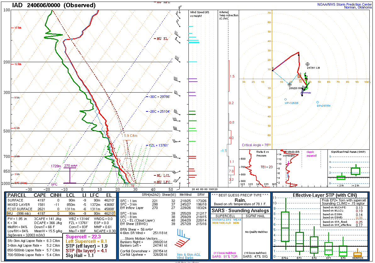
The environment that this evenings storms had. I do wonder if that surface dewpoint is a bit high though.
- 1,696 replies
-
- 1
-

-
- severe
- thunderstorms
- (and 5 more)
-
Confirmed TW now for Montgomery county.
-
Yeah. That near Poolesville couplet is legit.
-
LARGE TW now covering NE Loudoun, SE Frederick and western Montgomery counties.
-
New TW with the Leesburg cell.
-
The best web-based radar by far, that I know, of for sure. Hopefully it's back up soon.
-
Cell north of Remington in southern Fauquier county has some very weak rotation with it. Another area of weak rotation approaching Morrisville... nothing much as of the moment just showing that there is some ll shear in place.
-
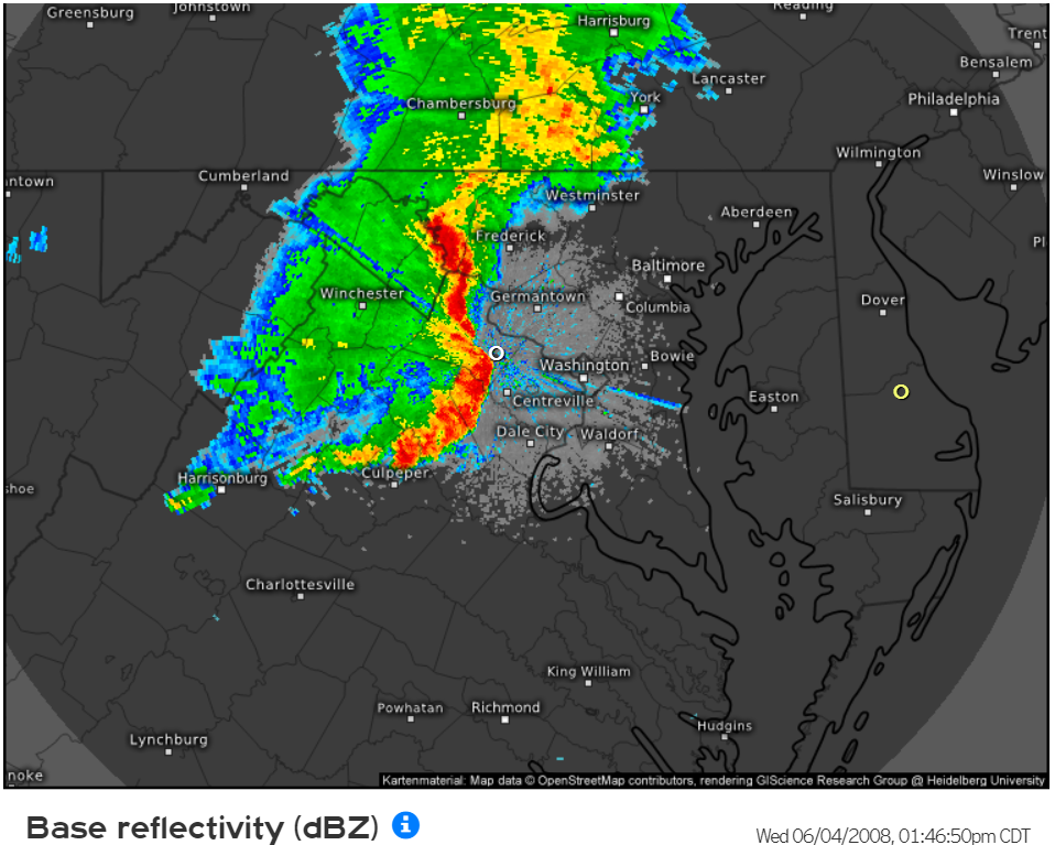
Fun times 16 years ago this moment. Let's do this again soon.

- 1,696 replies
-
- 7
-
-
- severe
- thunderstorms
- (and 5 more)
-
Welcome to meteorological/climatological summer.