
TriPol
-
Posts
1,898 -
Joined
-
Last visited
Content Type
Profiles
Blogs
Forums
American Weather
Media Demo
Store
Gallery
Everything posted by TriPol
-
Are you going to stick around here after this storm is over?
-
 25+? No. 20+? Yes. I'm thinking this storm is more west than east. I think that with how explosive it will be, will give 2-3 inch per hour snowfalls under some really awesome deathbands. I think from 8 pm - 8 am is our window. Say we get a few inches before that and a few inches after that. I think this breaks records.
 -
What are they going to do? Call the police? Driveways need to be clear.
-
It'll be too late by then.
-
What would you update them to now?
-
NYC 29.8 LGA 25 ISP 32 JFK 33 EWR 26
-
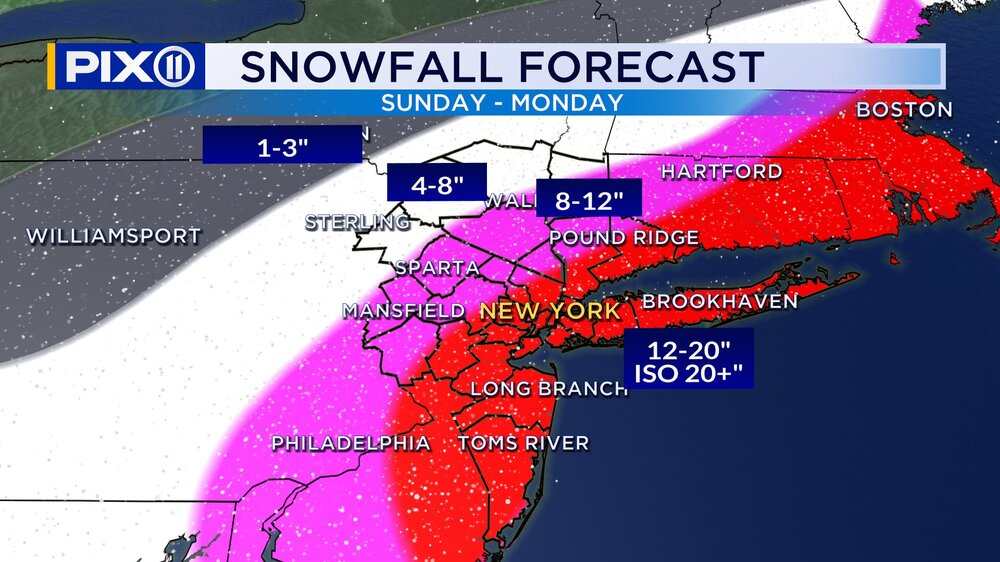
Pix 11 forecast
-
Why do you think the EURO is so far off-base?
-
The Blizzard Warning goes into effect at 1 pm tomorrow.
-
I think what's at issue here is A: How much precip falls B: How much of that preceip is frozen I've seen anywhere from 1 inch to 3.5 inches of precip over NYC.
-
A sub 980 low on or close to the benchmark in mid-late February in NYC always delivers. Once we're talking about 18-24 inch snowstorms, 1888, 1978, 2006, 2016... they're all in the conversation.
-
Congrats, man. You've been wanting this storm for a while. Hope you enjoy it.
-
It's insane that a "realistic" scenario for NYC is two feet of snow. I love it.
-
https://townersweatherpage.blogspot.com/p/weather-model-run-times.html Just so everyone has the ability to see this. It's a bit old and doesn't include the 6z and 18z times of the EURO as well as the run times of the AI versions of the GFS and EURO, but it's still somewhat helpful:
-
That happened for Sandy too. People were in denial. We knew what was going to happen two weeks out.
-
Dude - every model agrees with the NAM.
-
And Tuesday
-
Maybe we get a foot.
-
1996 isn't even in the top 5 snowfalls at Central Park anymore.
-
They've actually been pretty spot on this year with snow measuring at Central Park.
-
I think we break the record. I think we break 2006 and maybe 2016's record.
-
How is it possible for the NAM to outdo itself every run?
-
With the sREFs, the NAM, and the HRRR all on board giving us an absolutely historical blizzard and the NWS telling us 13 - 18 inches, I have no clue why TV meteorologists are still saying "6 - 10 inches." Are they really hugging the EURO this much and think everything is going to come around to support the EURO?
-
-
In a different thread.


