All Activity
- Past hour
-
Definitely living up to its billing as the swamp. I was shocked with widespread 100-110F heat indices, that there is not even a heat advisory. I think most places in the US would melt in those conditions. Yikes.
-
The naming of those two storms probably would not have happened in the past and the further in the past you go the less likely they would have been named. This is why comparing the amount of storms in todays world with past history, is flawed.
-
Its very windy imby
-
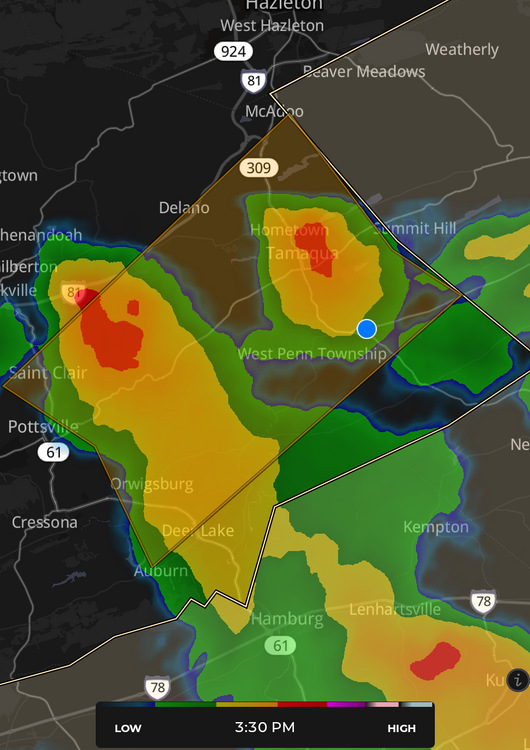
0.31" from whatever got Tamaqua.
-

July 2025 Obs/Disco ... possible historic month for heat
Torch Tiger replied to Typhoon Tip's topic in New England
my o my, this is going to be good -
Three different wind fronts interacted with each other on KDIX radar just south of @FPizz land.
-
91 here today. Does anyone on the forum live near central park? Who cares. It gets wayyyyy too many posts. We all know the issue, move on already. Wrong summer temps and can't measure snow.
-
High of 92 today.
-
88 here in Scranton. Here for the night to view The Office Tour.
-
93 here with heat index of 103 If we can sneak out another 90 tomorrow that will make heatwave #2 for me Heavy t storms look to scrape my area
-
Hopefully tonight we get some action. It looks like NAM brings in the action late evening. My area is getting swampy but the storms are fun lol
-
BUST
-
Where did your tee shot go on the par 3 pictured?
-
I'm in the low 90s. I thought it was supposed to be like 87 today?
-
Delayed but not denied
-
Continue to miss the cells, they develop a mile from me and then move NE and get stronger Some new activity forming just North of Baltimore currently.
-
Those clouds today hurt the usual spots from hitting 93-94. BDL still pulled off 90. There were times when it was almost complete cloudy for 15 minutes
-
92 here
-

E PA/NJ/DE Summer 2025 Obs/Discussion
JTA66 replied to Hurricane Agnes's topic in Philadelphia Region
Plenty of thunder and some wind, but nothing more than passing drizzle. Still, it was enough to knock my temp down to 81F. -
Close here at 88F currently.
-
Just hit 90 here
-

E PA/NJ/DE Summer 2025 Obs/Discussion
pl0k00n111 replied to Hurricane Agnes's topic in Philadelphia Region
Northeast philadelphia at my work. The gusts were very strong! Some hail and heavy sideways rain. It lasted a good 10 minutes before it passed. -

Central PA Summer 2025
Mount Joy Snowman replied to Voyager's topic in Upstate New York/Pennsylvania
A couple brief downpours here over the past couple of hours helped to temporarily knock back the heat. -
Finally got one in Tamaqua, but I'm sitting in the eye doctor's chair where the blue dot is...
-

E PA/NJ/DE Summer 2025 Obs/Discussion
Hurricane Agnes replied to Hurricane Agnes's topic in Philadelphia Region
Rain tapering now. Was up to 1.63"/hr at one point and currently have 0.44" in the bucket. Temp got knocked down almost 20 degrees from my high of 94 today and it's currently raining lightly with temp of 73 and dp 73. With the dribs and drabs for June, I ended up with 3.62" for the month (so far).