All Activity
- Past hour
-

July 2025 Obs/Disco ... possible historic month for heat
dendrite replied to Typhoon Tip's topic in New England
Nice evening. Dews are way down.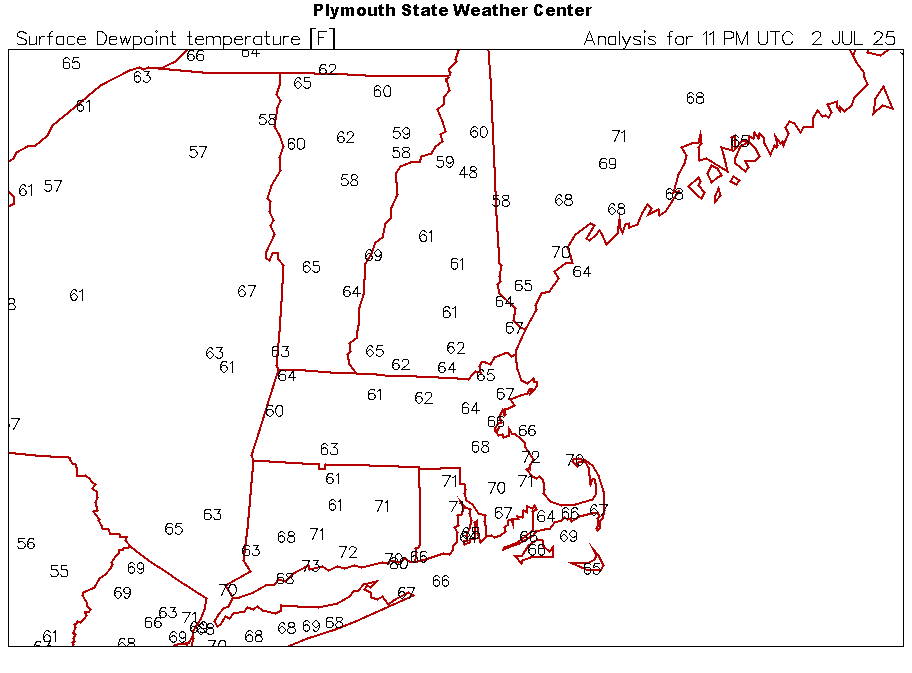
-
.thumb.png.4150b06c63a21f61052e47a612bf1818.png)
July 2025 Obs/Disco ... possible historic month for heat
HIPPYVALLEY replied to Typhoon Tip's topic in New England
80/66 pretty much perfect summer evening. -

July 2025 Obs/Disco ... possible historic month for heat
DavisStraight replied to Typhoon Tip's topic in New England
I used to like golfing and playing softball in this weather, other than that, I hate it. -
0.48" in north Wilson
-

July 2025 Obs/Disco ... possible historic month for heat
powderfreak replied to Typhoon Tip's topic in New England
Ha true, I was just thinking that trough could’ve been wet and cloudy… which turns 80/50 into 65/61 pretty quickly with wet-bulbing. Any day with full sun will be nice this time of year… even lower heights it’ll mix out nicely. -

July 2025 Obs/Disco ... possible historic month for heat
Sn0waddict replied to Typhoon Tip's topic in New England
That would be my guess. All I know is that it’s still raining heavily here. What a nuisance lol -

July 2025 Obs/Disco ... possible historic month for heat
Torch Tiger replied to Typhoon Tip's topic in New England
"much worse" that made me laugh. It's been an 85/50-55? ish day around here for a while....COC Maybe some storms up your way Saturday pm, NW flow. Need to see if there's anything available upstream. then Monday? You'll be closer to the front, better forcing, remnant boundaries etc. -

July 2025 Discussion-OBS - seasonable summer variability
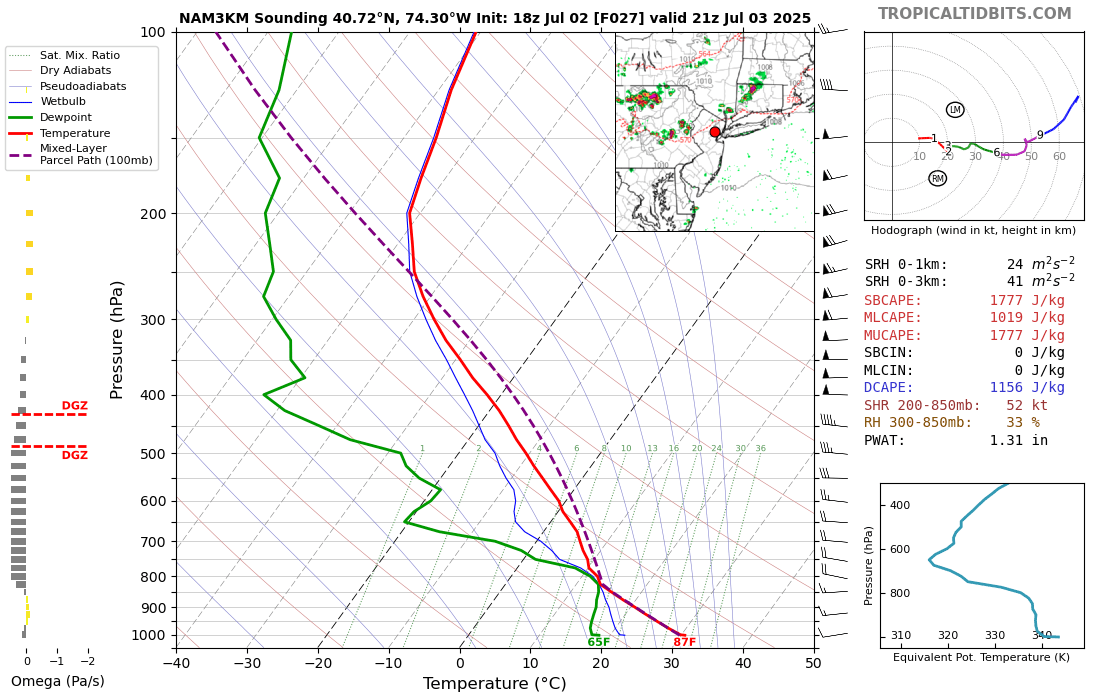
LongBeachSurfFreak replied to wdrag's topic in New York City Metro
That’s a pretty good sounding for around here. Someone is going to pull off damaging winds. I like the setups where storms come down from CT for the island. Some of the best wind events historically have been in that setup. -
July 2025 Obs/Disco ... possible historic month for heat
powderfreak replied to Typhoon Tip's topic in New England
Yeah it heats right back up and it’s not like a cloudy/wet cool pool anyway. Sun fixes things this time of year. That trough depth could’ve led to much worse weather on Friday. -
@WxUSAFjust wanted to say sorry for ending Elkridge 11U season at Clash of the Titan beach tournament.
-
July 2025 Obs/Disco ... possible historic month for heat
Torch Tiger replied to Typhoon Tip's topic in New England
This could be one of the better 4th of July weekends in recent memory. Despite the poorly-timed cool shot. Something worth considering - Today
-
It hit 121 F in Lytton, British Columbia on June 29th, 2021. Prior to the 2021 heat wave the previous high temperature in Canada was 112 F. It is interesting to note that the extreme heat and drought that day caused Lytton to burn to the ground...literally. A wildfire developed and consumed the entire town including the weather station before it could record the daily high on the following day.
-
I think there was one more of us up there who posted but I cant find it.
-
The family is down in Philly for the Phillies doubleheader today. The refreshing dew points are slowly moving in this direction.
-

July 2025 Obs/Disco ... possible historic month for heat
Snowedin replied to Typhoon Tip's topic in New England
Maybe it’ll give us a nice moisture laden storm to add to that beautiful tropical feel by the second half of the season. Headlines will read dews higher and stickier, the likes of which we’ve never seen before..Stay inside for the tropics of Belize are heading to a neighborhood near you! -

July 2025 Discussion-OBS - seasonable summer variability
forkyfork replied to wdrag's topic in New York City Metro
shear could be better but this is a good wind sounding
-

July 2025 Discussion-OBS - seasonable summer variability
Roger Smith replied to wdrag's topic in New York City Metro
Alligators falling from the sky in thunderstorms ... I wonder how that would look in a METAR? KCHS __ 29/27 3125G38 TRW+ Alligators all quads -

July 2025 Obs/Disco ... possible historic month for heat
FXWX replied to Typhoon Tip's topic in New England
Agree... -

July 2025 Discussion-OBS - seasonable summer variability
SACRUS replied to wdrag's topic in New York City Metro
trough/cold front moving through thu evenig focuses storms, rain showers north. The next 5 - 6 days look very dry /warm-hot (outside the 4th) . Next rain chances 7/8. -
July 2025 Discussion-OBS - seasonable summer variability
SACRUS replied to wdrag's topic in New York City Metro
Yeah outside of JFK/NYC which is the area he's referring to (i think) . 2010 - 2024(5) summer years have featured heat / strong heat as much as 48, 49, 53, 63, 66, 80,83,88, 91,93, 99 etc. -
July 2025 Obs/Disco ... possible historic month for heat
dendrite replied to Typhoon Tip's topic in New England
He’s out enjoying all of your water
-

July 2025 Discussion-OBS - seasonable summer variability
winterwarlock replied to wdrag's topic in New York City Metro
reached a muggy high of 88 today -
July 2025 Obs/Disco ... possible historic month for heat
Sn0waddict replied to Typhoon Tip's topic in New England
Definitely going to see some flooding if this doesn’t start moving soon. -

July 2025 Obs/Disco ... possible historic month for heat
Hoth replied to Typhoon Tip's topic in New England
Kinda fascinating. Only cell in SNE and it’s just sitting there. Maybe on a seabreeze boundary?