All Activity
- Past hour
-

Mountain West Discussion- cool season '23-24
Roger Smith replied to mayjawintastawm's topic in Central/Western States
On vacation in Las Vegas and s Utah since Tuesday, gradual cooling trend ended with rain and gusty winds today, hot to warm to very cool, now just 40F at Kanab, UT (was 90F on Tues in Vegas). Both LAS and SLC set daily rainfall records, at 0.23" Vegas to 0.82" SLC. I think gradient of rainfall in between was fairly linear so about 0.4" fell in parts of s Utah. It is the first significant rain in Vegas and s UT since winter ended but the wet winter resulted in very good desert blooming, saw lots of flowering cactus on display at Desert National Wildlife Refuge located about ten miles north of Vegas outer suburbs on US95, if you get a chance it's a very interesting area, as is nearby Red Rock Canyon and Fire Valley State Park. Going to various national parks in UT now but in most cases have visited before so we know what to expect (life elevated). -

Severe Weather 4-25 through 4-28-24
WxSynopsisDavid replied to cheese007's topic in Central/Western States
I absolutely agree with your analysis so far. If storm mode is not messy later today, this environment has the hallmark and look of a classic tornado outbreak. Hard to imagine it surpassing what we seen yesterday. However, the parameter space is more significant. Very possible if things come together this could be a Friday repeat but over a much larger areal capacity. - Today
-

E PA/NJ/DE Spring 2024 OBS/Discussion
PhiEaglesfan712 replied to Hurricane Agnes's topic in Philadelphia Region
Here is the analysis for PHL during the same period. The 2010s, on the strength of the first 3 years (2010-2012) broke the record by over one degree from the previous decade. The 2020s are on pace to break that record. 1890s - 51.84 1900s - 52.51 1910s - 52.98 1920s - 53.23 1930s - 53.18 1940s - 52.81 1950s - 52.83 1960s - 51.31 1970s - 53.16 1980s - 52.89 1990s - 53.85 2000s - 54.17 2010s - 55.38 2020s - 55.34 (this will likely increase after 2024) Long term average: 53.16 -
Thank you all for the great images and coverage. Will tune in tmr. Stay safe everyone
-
-
Yeah. Tomorrow looks ugly. If for nothing else, you could see a Moderate Risk, simply for the fact that the storms are likely, regardless of storm mode, supercell longevity, etc. Whether they are numerous or more isolated/intense, it seems like the overall probability of severe across central into eastern Oklahoma is quite high and may warrant higher severe probabilities. Really the only things that could dampen the threat a bit would be a mass of early day storms and outflow, along with messy storm modes. Even in this “best” case, it seems probable that a storm or two threads the needle. Buckle up.
-
Uh oh.
-
one of the latest tornadoes tonight
-
Definitely a day to remember. One of the larger Plains April tornado outbreaks in several years. Tomorrow is a really complex day. I’m not even going to pretend to look at it in detail, outside of Oklahoma. Since I live right in the middle of the threat zone. Guidance is in strong agreement with early storm initiation, we’re talking scattered to numerous thunderstorms in Oklahoma by late morning. 00z HRRR and to some extent the 00z 3km NAM show most of the ML CIN eroded by 18-19z over much of the state. There really are several scenarios for Oklahoma… 1. Early day convection is widespread and largely sub-severe. It would overturn the environment and limit the potential for isolated supercells. Still, this scenario would likely produce some large hail and damaging winds, along with at least a threat for a few brief tornadoes. 2. Early convection is somewhat isolated, but still occurs. Some of the storms are severe, but the main story is redevelopment south/east of the early day storms in the afternoon. You could see at least a couple of supercells evolve, with a severe/tornado risk. Outflow boundaries would be key to watch, especially as the low level jet cranks up late day. 3. There is little early day convection, but given expected thermodynamics, supercells erupt relatively in the afternoon. Even if there are numerous storms, mergers and interactions, the parameter space will support significant severe, in the form of very large hail and strong tornadoes. Based on what I’m looking at, virtually all of the high res guidance shows a volatile parameter space by midday, at least on an isolated basis across Oklahoma. I’m also seeing some kinks in the forecast hodographs between 2-4km, at least through much of the day. This may dampen the longevity of supercells, particularly with early day into afternoon storms. No matter what scenario happens, I’d expect a fairly messy storm mode with at least a few supercells. This may mitigate the risk for long track tornadoes (like what Nebraska/Iowa saw today). However, it may be hard to get advance warning lead time if you have a complex, clustered storm mode with embedded supercells spinning off tornadoes. If the atmosphere isn’t completely overturned, there’s the potential for some very large hodograph curvature by 00z, as the low level jet kicks in. Look at any high res model and you can see daily (cherry) pick PDS Tor soundings around the area. It’s going to be a long Saturday…
-
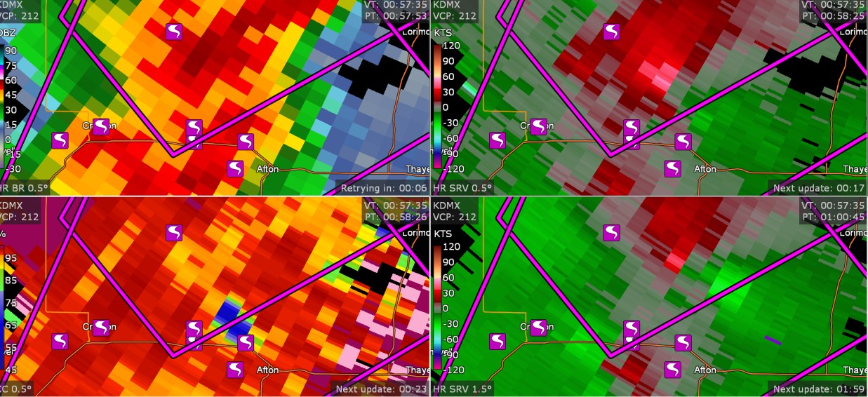
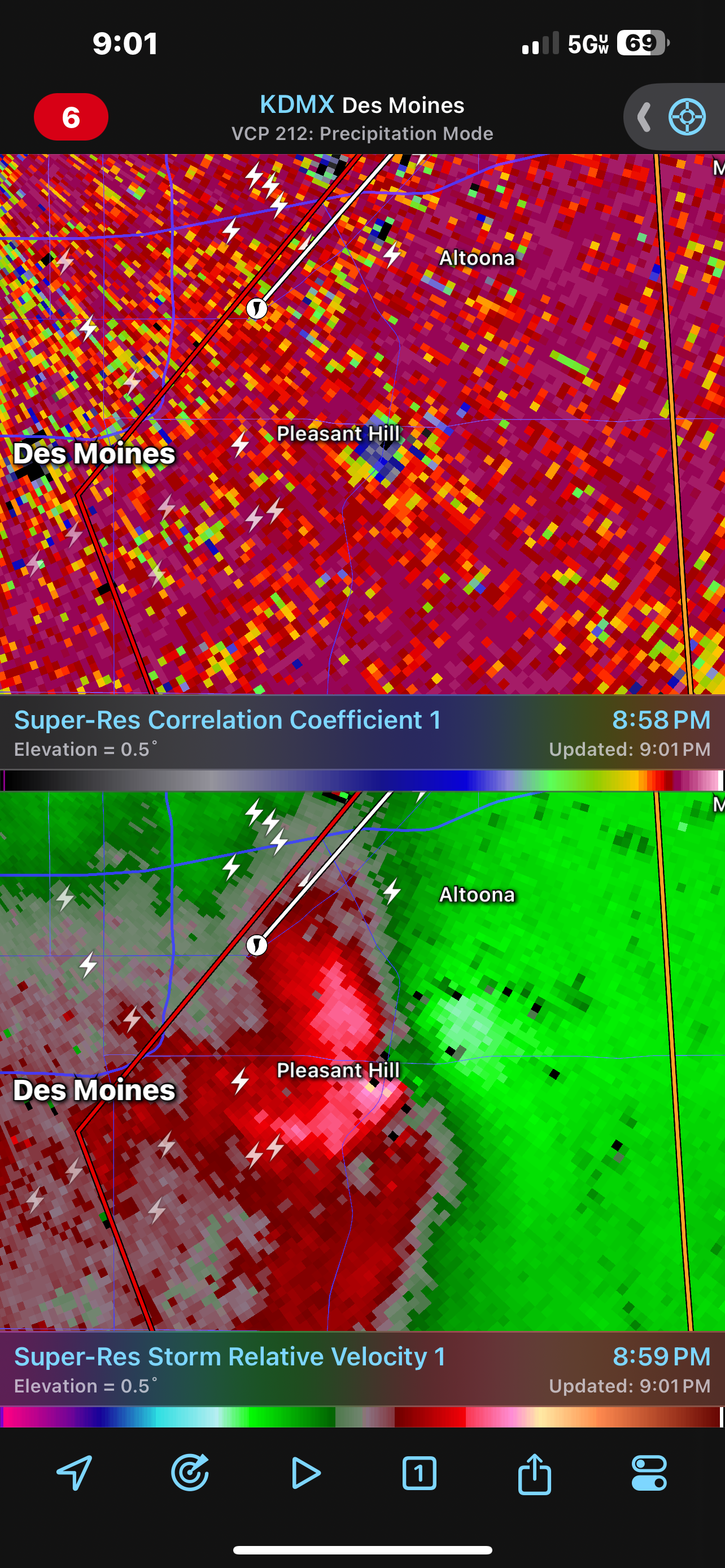
I went out tonight and I didn't look at my computer since 8:15. But I left my GRLevel3 on, and it saved data. I discovered this cluster of 7 tornadoes. (8:57PMEDT) I have no idea how 7 tornadoes happened here near Afton Iowa. And, by the way, there are 95 tornadoes on SPC storm reports.

-
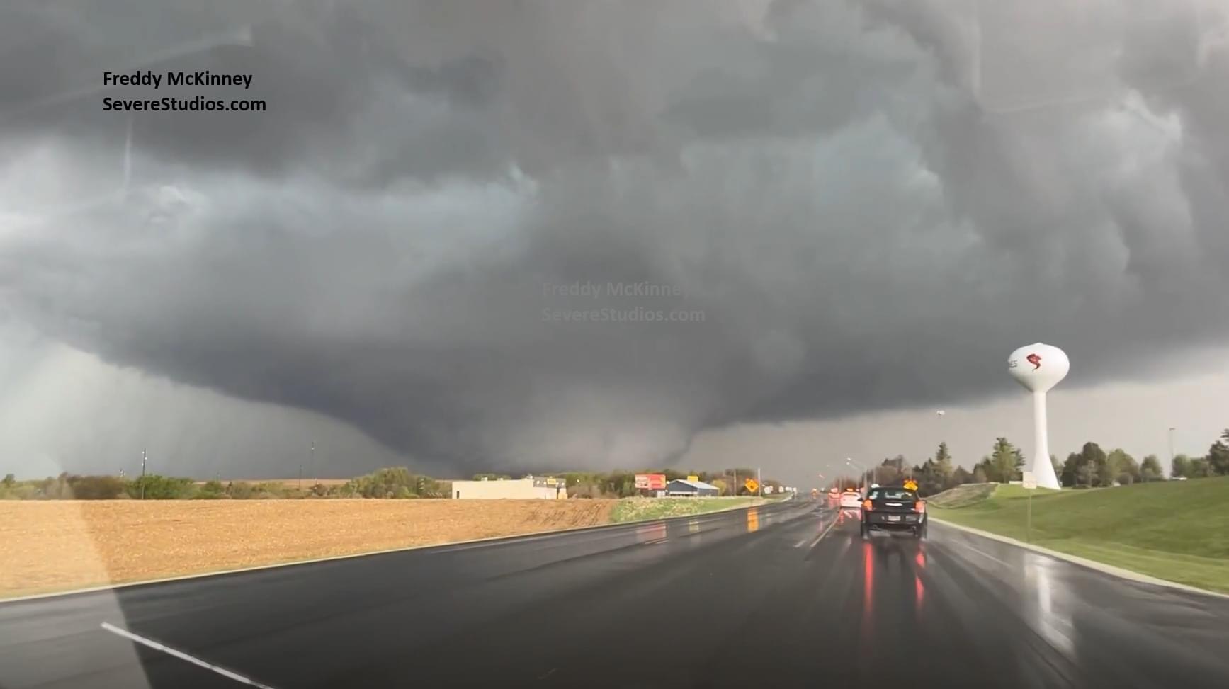
Severe Weather 4-25 through 4-28-24
WxSynopsisDavid replied to cheese007's topic in Central/Western States
This shot from Storm Chaser Freddy McKinney, mark my words, will be in the history books. What a monstrous, powerful, and truly violent tornado. Photographed right as it peaked in width and intensity. This shot has Rochelle, Illinois vibes.
-
That game sucked.
-

4/25-4/28 Severe and Heavy Rain Threat
SchaumburgStormer replied to Geoboy645's topic in Lakes/Ohio Valley
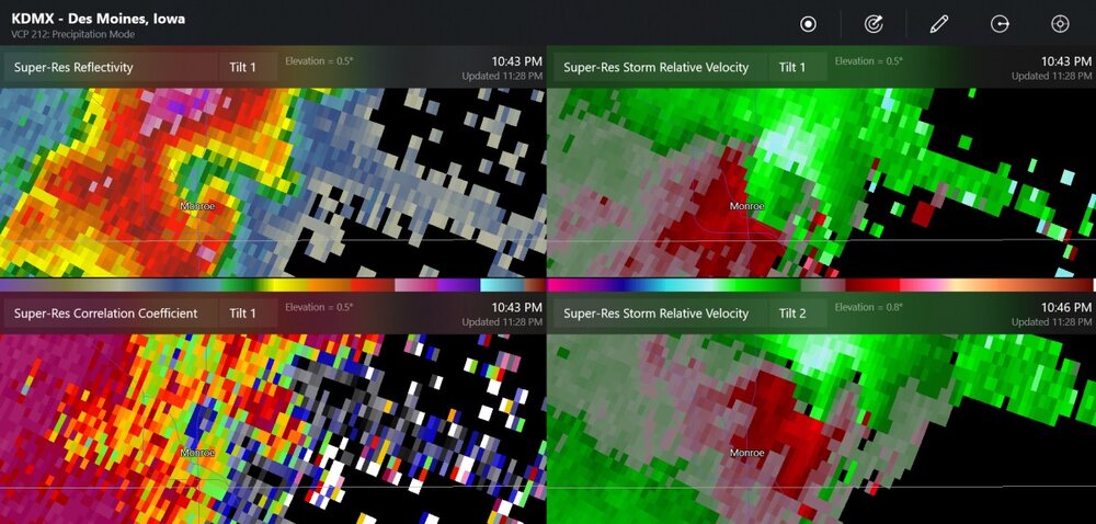
Another TDS east of Des Moines -
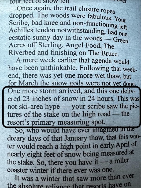
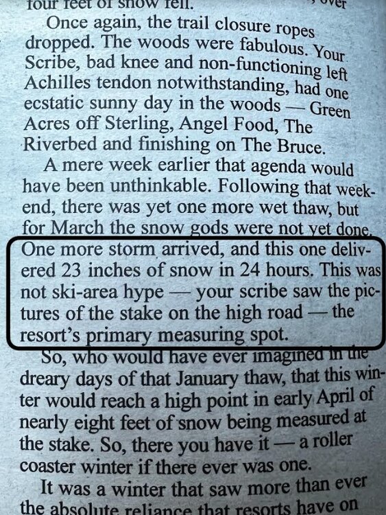
Ha, thanks, it's just a passion for mountain weather and being in the right spot at the right time over a decade ago. People did not believe ski area snow reports, and they still don't most of the time. Since the start of the ski industry in the northeast back in the 1950s, there was optimistic embellishment to sell a product that was very weather dependent. Even if it snowed, or the weather sucked, there's an economic reason to sugarcoat it. And resorts/ski areas did, Stowe included, if not leading the charge back in the day. The 1980s to the 2000s seemed to be prime time for snow reporting in the northeast to lose trust among skiers/riders. The advent of the internet. No longer was it just print, TV, or radio snowfall. In the 2000s, Snow Reporting had a wake up call once folks started getting on social media and information traveled rapidly among users. To me, I had always liked western ski area snow reports. They were always matter of fact, snowfall from a designated plot, and were consistent due to avalanche dangers; there's no time to mess around out west with snow and weather observations. But at the same time, its part of the culture on eastern snow reports to be a bit less rigid, so to speak. Alta's Collins Plot is my favorite out west by far. Automated snowfall readings by sensors every hour that are very accurate, I'd do anything for that technology. It is where Alta records their snowfall every season. It is at 9,500ft, not 11K or 8.5K. Just a representative mid-mountain snowfall. They definitely get more snow up high, but their numbers provide skiers with a consistent value they can develop a familiarity with. You know what the number means for the mountain. These days with the cheap season pass market and the advent of the Epic, Ikon, etc, even Indy passes, the reason for ski areas to embellish has declined. People are going to come/visit, they already paid for it. The money is gathered up front before the season, you do not need to convince people to come on any given day. You can let them know what they need to know, when deciding if to come or not. Rain, snow, wind, freezing rain, powder or frozen granular. You just report it as fact these days. It's a great trend for eastern skiers and riders. Even high level marketers in the big ski conglomerates know that being honest and transparent is a positive marketing strategy these days (and the past decade really). Those who write the content are allowed to tell the story as truthfully as they can, which wasn't always the case at many ski areas in the past. I loved the High Road getting some play in the local newspaper, by the long-time Scribe. Kim Brown's column has been around for a very long time. He started writing as a ski bum way back over a couple decades ago… writing about the ski area news in the local paper and being a skeptic to the old school snow reports. He's got his weekly ski column documenting the last week of skiing at Stowe going on 20+ years? This was in his season recap this week.
-
Severe Weather 4-25 through 4-28-24
WxSynopsisDavid replied to cheese007's topic in Central/Western States
Depends on the construction of the house. A poorly constructed house can be leveled by an EF2/EF3. -

Severe Weather 4-25 through 4-28-24
Witness Protection Program replied to cheese007's topic in Central/Western States
Houses blown down to their foundations, is that common for EF3 or does that likely move it to a 4? -

Extended summer stormlover74 future snow hole banter thread 23
SRRTA22 replied to BxEngine's topic in New York City Metro
Definitely some impressive large tornadoes out there in the plains today -
Thought a home game against the As would be a sure fire win... Ugh. Well still had some fun with the kids at the ballpark.
-

Severe Weather 4-25 through 4-28-24
WxWatcher007 replied to cheese007's topic in Central/Western States
-

Pittsburgh/Western PA Spring 2024
TheClimateChanger replied to Ahoff's topic in Upstate New York/Pennsylvania
If the forecast for the rest of the month is correct, we will finish with a mean temperature for the month of about 56.2F, which would be good for 7th warmest of record. Since 1955, only 2017 (57.3F) saw a warmer April. Also still a good chance at the #1 wettest April on record. -
Just a wild day out there
-
4/25-4/28 Severe and Heavy Rain Threat
SchaumburgStormer replied to Geoboy645's topic in Lakes/Ohio Valley
Rain wrapped too. -

May 2024 temperature forecast contest
rainsucks replied to Roger Smith's topic in Weather Forecasting and Discussion
DCA: +1.7 NYC: +1.5 BOS: +1.0 ORD: +2.0 ATL: +1.5 IAH: +1.3 DEN: +1.5 PHX: 0.0 SEA: +1.0 -
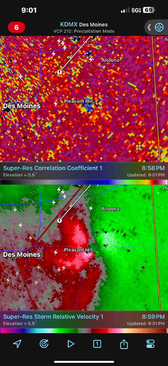
Severe Weather Statement National Weather Service Des Moines IA 857 PM CDT Fri Apr 26 2024 IAC099-153-270230- /O.CON.KDMX.TO.W.0023.000000T0000Z-240427T0230Z/ Polk IA-Jasper IA- 857 PM CDT Fri Apr 26 2024 ...A TORNADO WARNING REMAINS IN EFFECT UNTIL 930 PM CDT FOR SOUTHEASTERN POLK AND WESTERN JASPER COUNTIES... At 857 PM CDT, a confirmed large and extremely dangerous tornado was located over Pleasant Hill, moving northeast at 35 mph. This is a PARTICULARLY DANGEROUS SITUATION. TAKE COVER NOW! HAZARD...Damaging tornado. SOURCE...Radar confirmed tornado. IMPACT...You are in a life-threatening situation. Flying debris may be deadly to those caught without shelter. Mobile homes will be destroyed. Considerable damage to homes, businesses, and vehicles is likely and complete destruction is possible. The tornado will be near... Des Moines, Altoona, Pleasant Hill, Bondurant, Adventureland Amusement Park, and Prairie Meadows around 900 PM CDT. Mitchellville around 905 PM CDT. Valeria around 915 PM CDT. Colfax around 920 PM CDT. Mingo around 925 PM CDT. Other locations impacted by this tornadic thunderstorm include Mingo, Valeria, and Runnells. This includes the following highways... Interstate 80 between mile markers 140 and 155. Interstate 235 between mile markers 10 and 12. PRECAUTIONARY/PREPAREDNESS ACTIONS... To repeat, a large, extremely dangerous and potentially deadly tornado is on the ground. To protect your life, TAKE COVER NOW! Move to a basement or an interior room on the lowest floor of a sturdy building. Avoid windows. If you are outdoors, in a mobile home, or in a vehicle, move to the closest substantial shelter and protect yourself from flying debris. Heavy rainfall may hide this tornado. Do not wait to see or hear the tornado. TAKE COVER NOW! Tornadoes are extremely difficult to see and confirm at night. Do not wait to see or hear the tornado. TAKE COVER NOW!
-
4/25-4/28 Severe and Heavy Rain Threat
SchaumburgStormer replied to Geoboy645's topic in Lakes/Ohio Valley
Yikes, she’s chewing.