All Activity
- Past hour
-

The “I bring the mojo” Jan 30-Feb 1 potential winter storm
KrummWx replied to lilj4425's topic in Southeastern States
Damn FAY! Can't remember the last Fayetteville jackpot -

The “I bring the mojo” Jan 30-Feb 1 potential winter storm
burgertime replied to lilj4425's topic in Southeastern States
It should be enough -

Richmond Metro/Hampton Roads Area Discussion
RVASnowLover replied to RIC Airport's topic in Mid Atlantic
It's close but yet so far -
18Z NAM is a beaut!
-
Beautiful Sent from my SM-G998U using Tapatalk
-

The Jan 31 Potential: Stormtracker Failure or 'Tracker Trouncing
stormtracker replied to stormtracker's topic in Mid Atlantic
It's better. But not good enough -
precip a bit more robust on the NW Side of the NAM-still 2 lows though
-
The “I bring the mojo” Jan 30-Feb 1 potential winter storm
burgertime replied to lilj4425's topic in Southeastern States
Out 78. CLT and eastern NC are big winners -
 Does that precip going through north Georgia reach the ground?
 -
Looks like we are getting NAM'd.
-

Richmond Metro/Hampton Roads Area Discussion
overcautionisbad replied to RIC Airport's topic in Mid Atlantic
NAM is running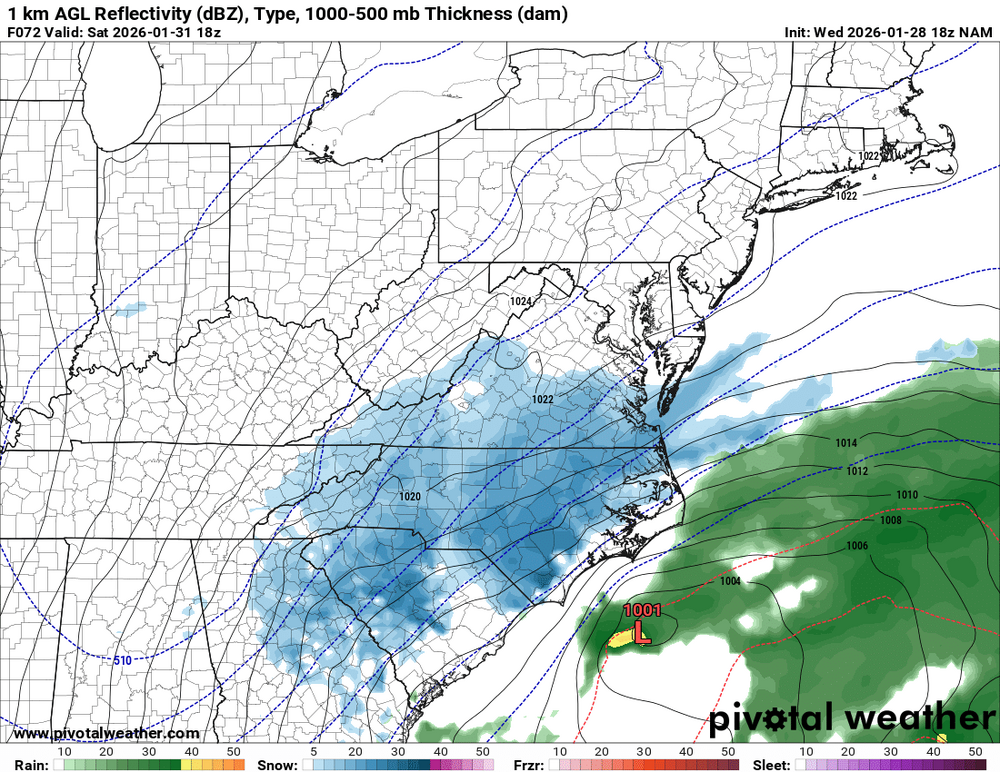
.thumb.png.56b1bac5b7105914ab6e9a9ca558dd03.png)
-
NAM pretty different .
-
 My stance on this storm hasn't much changed. Despite the amazing H5 pattern this particular storm has been a long shot. The best run of the Euro ens runs never got DC above 30% chance for an inch of snow! While the storm isn't set in stone yet we need to see some H5 changes by tomorrow at this time or else its probably over. Still hoping that personally I get the non-coastal to form far enough north to get some light snow.
 -

The Jan 31 Potential: Stormtracker Failure or 'Tracker Trouncing
Paleocene replied to stormtracker's topic in Mid Atlantic
max hopium copium the nam is more neutral than 12z run lol.thumb.jpg.927fc46fa0aea7d48ed97c872324769f.jpg)
-
how do we get more precipitation in the southern valley? Need that pivot to me further south? or southwest?
-

Possible coastal storm centered on Feb 1 2026.
dendrite replied to Typhoon Tip's topic in New England
Ditty knows what I mean -

The Jan 31 Potential: Stormtracker Failure or 'Tracker Trouncing
Buddy1987 replied to stormtracker's topic in Mid Atlantic
Honestly i'd be totally fine with this. Beggers can't be choosers. -

1-30/2-1-26 Arctic Blast, ULL Snow Event
fountainguy97 replied to John1122's topic in Tennessee Valley
the NAM is a beauty. just gorgeous pivot over ETN -
The “I bring the mojo” Jan 30-Feb 1 potential winter storm
burgertime replied to lilj4425's topic in Southeastern States
The NAM out to 66 -

Richmond Metro/Hampton Roads Area Discussion
Ephesians2 replied to RIC Airport's topic in Mid Atlantic
So I know the main thread gave up after seeing the Euro... but it really isn't that much worse than 06z and is similar to 00z, while being much better than some of yesterday's runs. I have a feeling that this can bump north a bit and that Central VA at least has a shot at a warning level event or at least a 1-3"/2-4" snow from the ULL like last february. What would kill it is a progressive/east trend. Being south of the bullseye is one thing, but it needs to go negative and amplify fast. It is a volatile setup, way more than last storm. Still a lot of disagreement at 60-84 hours.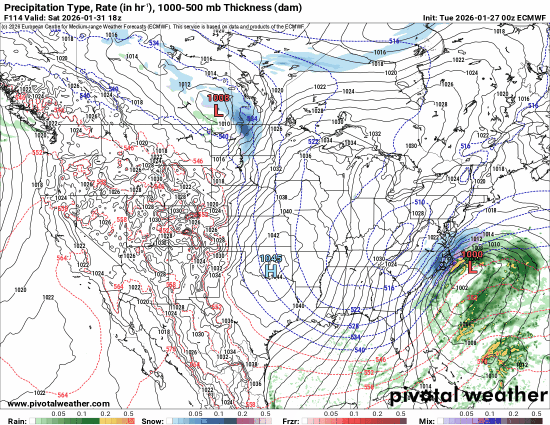
-
BCPS going virtual learning remainder of the week. Thank goodness, my kid needs some routine in her life haha
-

Possible coastal storm centered on Feb 1 2026.
WinterWolf replied to Typhoon Tip's topic in New England
He’s just being a clown..f’n around is all. -

1/30-1/31 Lake Effect Snow Threat - SE WI, NE IL, and NW IN
Chicago916 replied to A-L-E-K's topic in Lakes/Ohio Valley
We're all owed at least one run with a peak of 30in somewhere despite not being possible. -
WE will all be done after another 4 weeks of this cold
-
The “I bring the mojo” Jan 30-Feb 1 potential winter storm
KrummWx replied to lilj4425's topic in Southeastern States


.png.0dde9b656f9ee613c22865a2d1a19301.png)

.jpg.2c9f5931a36c06dcfda042442a8ae9fb.jpg)


