All Activity
- Past hour
-
Foot deep piles of insects that have destroyed the vegetation, does sound like a DIT dream. Destruction and not boring.
-
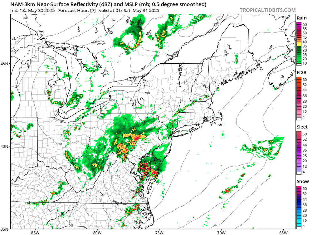
GFS with its usual genesis bias but the overall signal for a window remains.
-
My chickens would love that. Some cicadas too.
-
Also—we pray for GFS with June tropical but it’s just eye candy
-
My God. Kev would have a field day with that until they swarmed his AC vents.
-
-
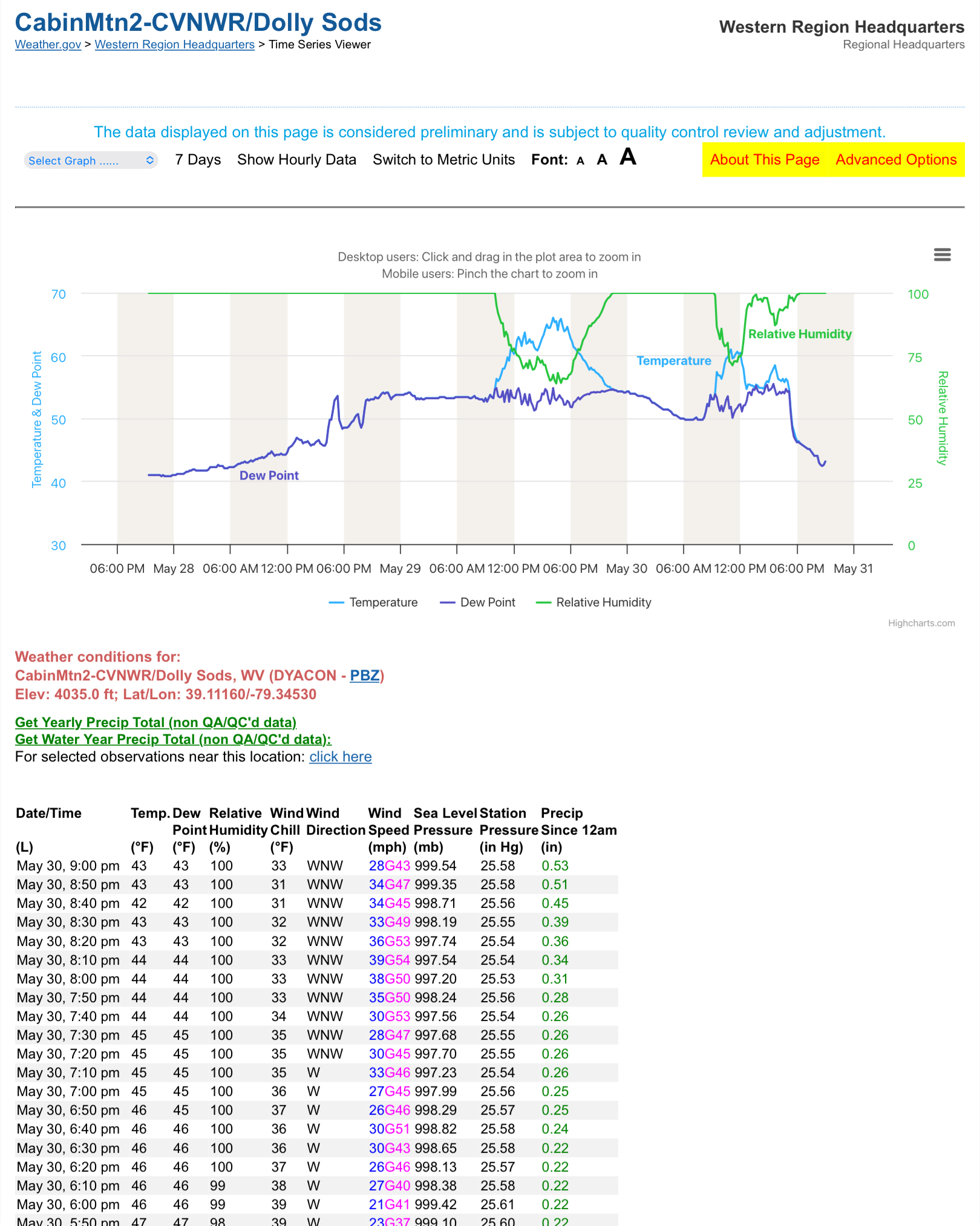
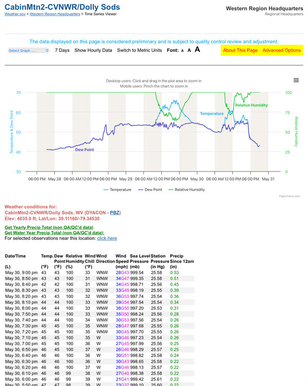
They fixed the wind advisory to tomorrow morning instead of Sunday
-
All but one flight delayed or canceled here at DCA
-
Locusts might be fun. "Compared to previous infestations in the region, the 1874 plague was significantly more damaging. The invasion coincided with a record drought in the Midwest and Great Plains, which induced the grasshoppers (estimated at 120 billion to 12.5 trillion) to not only thrive but also to swarm when local vegetation was decimated. The arriving locusts would pile up to over a foot high and ate crops, trees, leaves, grass, wool off sheep, harnesses on horses, paint from wagons, and pitchfork handles.
-
Everything is moving out quick. Going to be a bust here in 21057
-

E PA/NJ/DE Spring 2025 Obs/Discussion
RedSky replied to PhiEaglesfan712's topic in Philadelphia Region
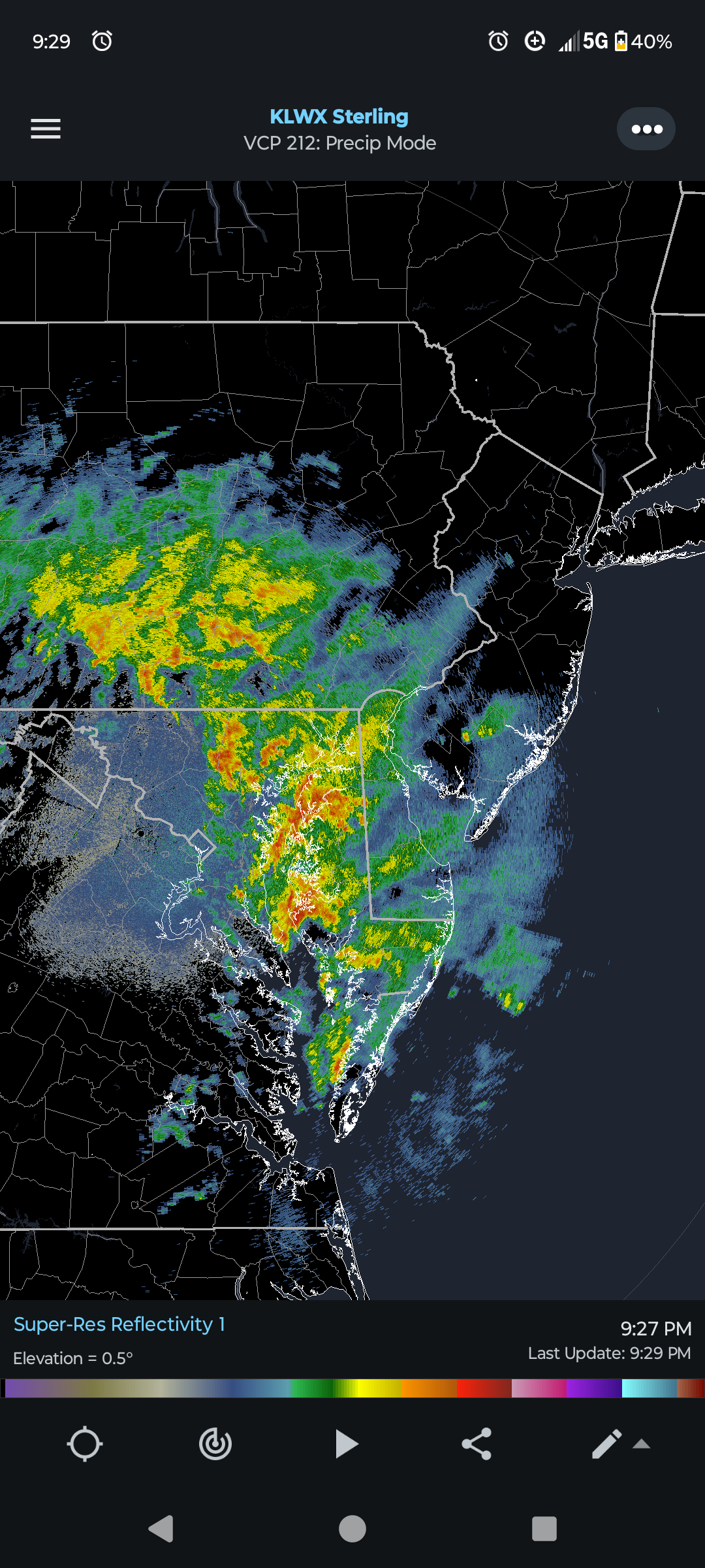
Looks like trouble this is the time for flood guy -
Wind. We haven't had that at all lately lol
-
Not sure how far N that watch goes but they are getting far more rain in say State Collage than here it seems
-
Back to steady rain and no lightning or thunder. Yeah I was questioning the 30 hour wind advisory too.
-
Ha... I was wondering whether they meant to issue it until 6am TOMMORROW morning and NOT Sunday morning as that would make more sense looking at the models. They've been very busy at the office this evening. URGENT - WEATHER MESSAGE National Weather Service Baltimore MD/Washington DC 920 PM EDT Fri May 30 2025 DCZ001-MDZ004>006-008-011-013-014-016>018-503>508-VAZ038>040-051-053- 054-501-502-505-506-526-527-310930- /O.EXT.KLWX.WI.Y.0016.250531T0400Z-250531T1000Z/ District of Columbia-Frederick MD-Carroll-Northern Baltimore- Cecil-Southern Baltimore-Prince Georges-Anne Arundel-Charles-St. Marys-Calvert-Northwest Montgomery-Central and Southeast Montgomery-Northwest Howard-Central and Southeast Howard- Northwest Harford-Southeast Harford-Greene-Madison-Rappahannock- Culpeper-Fairfax-Arlington/Falls Church/Alexandria-Northern Fauquier-Southern Fauquier-Western Loudoun-Eastern Loudoun- Northwest Prince William-Central and Southeast Prince William/Manassas/Manassas Park- 920 PM EDT Fri May 30 2025 ...WIND ADVISORY NOW IN EFFECT UNTIL 6 AM EDT SATURDAY... * WHAT...West winds 15 to 30 mph with gusts up to 50 mph. * WHERE...Portions of DC, central, north central, northeast, northern, and southern Maryland, and central, northern, and northwest Virginia. * WHEN...Until 6 AM EDT Saturday. * IMPACTS...Gusty winds will blow around unsecured objects. Tree limbs could be blown down and a few power outages may result. PRECAUTIONARY/PREPAREDNESS ACTIONS... Winds this strong can make driving difficult, especially for high profile vehicles. Use extra caution. Secure outdoor objects. && $$ DHOF
-
oops
-
I’m not into warm anything really so appreciate the second cooler month than average in a row
-
-
Correct me if I'm wrong, but on the current and future radar loop, it looks like the heaviest rain will fall north of the flood watch zone.
-
Not thrilled about this given how saturated the ground is and the significant damage the Alexandria area endured two Friday’s ago.
-
Woot woot. It's the second run in a row with a tropical system in this range. I'm sure it'll be rock solid for the next 30+ runs.
-
Pleasant.
-
Wtf?
-
Final squally/gusty line was intense IMBY after 830. gonna find branches down in the nhood tomorrow. Power didn't flicker though
-
Widespread hundies