All Activity
- Past hour
-

2025 Atlantic Hurricane Season
WxWatcher007 replied to BarryStantonGBP's topic in Tropical Headquarters
I can see where the numbers come from, but I'm guessing that with an active back half of September that projection will change. I don't see sub 140 ACE, but I also don't think we're rocketing toward hyperactive ACE either. I'd probably lean around 150. Kind of agree on the 3+ H strikes, considering that I think this is an EC, not Gulf favored year. That in it of itself suggests fewer than 3 strikes. With us being where we are and my peak season forecast at 10/6/3, I'm thinking we're probably around 15/7/4 to end the season. All I care about is my peak season forecast though. -
I lost my no 90's streak. 91 at 3:55pm yesterday, will probably see it again today. Currently 88 at 1:35pm.
-
I'll also add that these landfalls you mention also highlight just how difficult it is to get an east coast hurricane strike. Much like New England, but obviously to a lesser degree, it takes a statistically unlikely alignment of steering forces to bring a major hurricane to the EC, even with homebrew nearby.
-

2025 Atlantic Hurricane Season
LongBeachSurfFreak replied to BarryStantonGBP's topic in Tropical Headquarters
There’s no way 190 ace is happening with a lull right during peak season. A strong backend is still likely based on increased vertical instability but it’s going to be hard to make up for lost time. Erin also cooled a large portion of the typical recurve track which will limit future storm intensity in that region. -
Thanks for the question. I think it's too specific to look at a place like FL vs the Carolina coast. Part of the analysis is pretty basic. The more active a season is the more likely there is a landfall generally, just because more storms equal more opportunities. In my analysis though, it goes a little beyond that. First, look at the thermodynamic environment in the genesis and "final track" (locations that a TC would need to cross to make landfall) areas. In spite of Erin's impressive wake, there is still an enormous amount of untapped potential in the Gulf, Caribbean, and in the southwest Atlantic. Second, I think the ENSO and wet Sahel analysis is compelling. I think the wet Sahel in particular is interesting because track density is consistent with what looks like a hostile tropical Atlantic that suppresses waves until you approach the Antilles and SW Atlantic. I also think that the anomalous troughing that we're seeing now in the east, while certainly a pattern for recurves, would quickly become a pattern for pulling Caribbean or SW Atlantic homebrew systems north if you look at it, especially if that pattern retrogrades as we head deeper into September (where I doubt we produce consecutive negative departure months in the eastern part of the country. I also think climatology plays a role here. @GaWx had a very interesting post looking at east coast landfalls later in the peak season. Storm genesis location matters here, and I am thinking with a slightly less robust wave train from past years, we see vigorous, but weaker waves that can get further west into the Caribbean or SW Atlantic. This could have implications for the eastern Gulf, but I do think troughing will be more of a feature that would lead to earlier turns than the western Caribbean unless something obviously develops there. I do think homebrew is the most likely way the east coast sees a hurricane strike. I actually think it probably means less of a chance, unless there is meaningful activity in the eastern Gulf (which has also been a hot spot of late so that can't be ruled out).
-
 would be wild if some states went to permanent DST and others went to permanent ST
 -
I find them funny.
-
Lake Michigan can produce dumps well into February, though more synoptic forcing becomes necessary the later you go it seems. Lake Eerie OTOH typically shuts down after any prolonged cold.
-
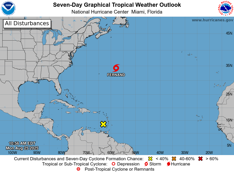
Gotta love TPC showing us that disturbance by the Windwards....then telling us it has a 0% chance of development.
-

Mid to long range discussion- 2025
WinstonSalemArlington replied to wncsnow's topic in Southeastern States
Fire pit and fireplace potential ahead from CWG -

2025 Lawns & Gardens Thread. Making Lawns Great Again
wxeyeNH replied to Damage In Tolland's topic in New England
I have a question about grass dormancy. I have never had the SW part of my lawn burn out like this. Just crunchy brown grass. Large areas of 0% green. If we don't get any substantial rain soon with little time for green up this season, will my lawn come back next year? If it is 100% brown? I guess I can have it overseeded, it's a large area. -
.36" yesterday. Hot spot in Augusta was Weyers Cave with .75". A 5 location blend at Charlottesville was .47".
-
 Ten endless battle of locking the clock at ST or DST continues and from the looks of it, we will inevitably remain on the DST Mar - Nov and ST Nov - Mar change. https://www.politico.com/live-updates/2025/04/30/congress/congress-daylight-saving-time-trump-00318033
 -

E PA/NJ/DE Summer 2025 Obs/Discussion
The Iceman replied to Hurricane Agnes's topic in Philadelphia Region
I’m having flashbacks from last fall, endless sunny days with clear skies and no rain in sight. I have a feeling we are going to need a tropical system to break up the upcoming dryness. -
Very sad it ends soon.
-
I saw the Stein. And it opened up my eyes I saw the Stein.
-
 Our sunsets in summer are late enough IMO. It's winter that sucks the life out of you, when you could see darkness approaching at like 3PM
 -
Into the holes? Man WTF?
-
86 / 50 , breeze - so allergies a bit up
-
Watch the period Sep 4 - 11th per the european for next shot at 90s outside the hot spots today, there is also the chance for a wetter / cut off like the gfs / ensembles show to update this map.
-

2025 Atlantic Hurricane Season
BarryStantonGBP replied to BarryStantonGBP's topic in Tropical Headquarters
139 ACE in a 9-year with a 9/16 Gulf major window and a mid-Oct SE echo? That’s peak weenie. I’m on 19/8/6, ~190 ACE... come at me outside Tesco's in Manny innit -
In the contest post (that you weenied lmao), I predicted 14/9/3 and 139 ACE. So, I expect another weenie here.
-
2025 Atlantic Hurricane Season
BarryStantonGBP replied to BarryStantonGBP's topic in Tropical Headquarters
Be careful what you wish for, innit. The only setup that could drown Chazza that weekend is a Gulf storm that shoots up the M85 (I meant the I-85), and the LRC + guidance put that corridor a full week later (mid-October). One storm I have is an Azores fish, the one following that isn't on deck till 10-12 Oct, and anything Caribbean-born needs time to clear Cuba. Translation: odds of a soggy CLT soakdown and a trampoline on 4 Oct are near zero. Looks like you’ll have to earn that 50 K the old-fashioned way: suffering upright, not floating. -
Enjoy the summer because it’ll be gone real soon. I’ve been getting over to Ogunquit Beach once every week or 10 days early in the morning to just enjoy the walk and soak in some morning sun. The good life.
-

E PA/NJ/DE Summer 2025 Obs/Discussion
LVblizzard replied to Hurricane Agnes's topic in Philadelphia Region
This weather is nice but the weenie in me wants more chances for storms. Or at least a good soaking rainstorm. I like a few days of beautiful weather like this but it gets boring when it goes on for too long.


